The Gaia art exhibit in Trinity College’s Long Room Library.
I can’t believe how much Russ and I meandered around Dublin on this day! We certainly felt grateful for our good fitness and working legs. Also, we learned that the buses in Dublin require exact change. You can put extra in, but you won’t get change back.
Taxi Driver Wisdom
The times we took cabs in Dublin, most of the drivers were talkative and friendly, but some weren’t, and that was okay, too. From them, we learned such gems as:
Although Guiness is seen as Irish, it’s actually an English-owned company. But that’s okay because the beer is so good!
Although the Irish band U2 is seen as lead singer Bono’s band, it’s actually the drummer’s band. The drummer is who hired Bono.
Dublin is synonymous with Las Vegas for the British. What happens in Dublin stays in Dublin.
One way to relieve arthritis knee pain is to soak a rag in whiskey and wrap it around your knee.
I have not fact-checked these claims, so take them as you will. We truly enjoyed our conversations with cab drivers both here and later in Scotland.
Molly Malone
The Molly Malone statue, Dublin
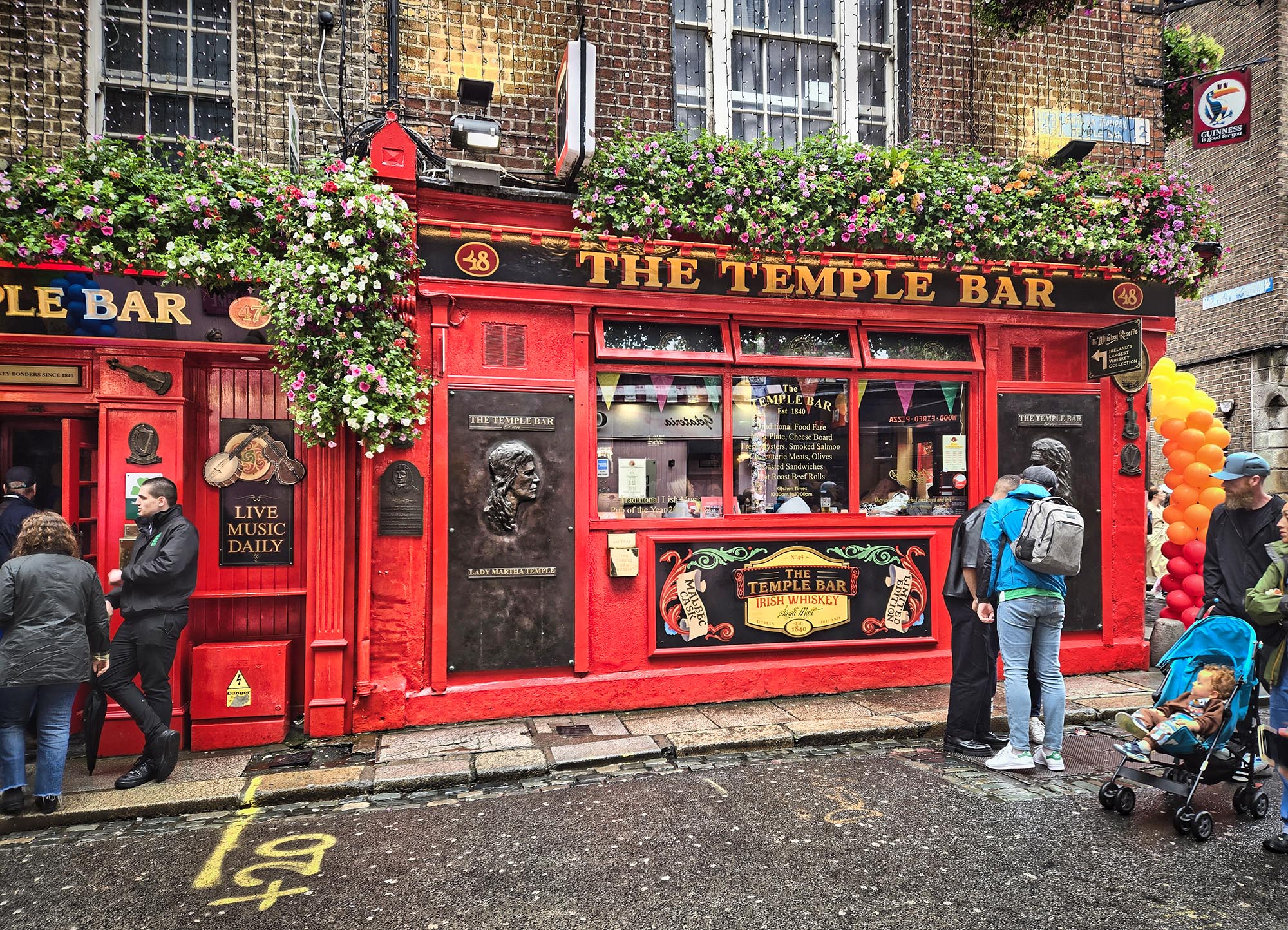
In my previous post, Russ and I had just finished visiting the Temple Bar. From there, we walked to Trinity College to fulfill our reservation to enter its famous Long Room and view The Book of Kells. We had plenty of time before we needed to be there, so we took a short side trip through the ever-present drizzle to see the Molly Malone statue.
Molly is a semi-historical, semi-mythical lady commemorated in the song “Cockles and Mussels,” which has become an unofficial Dublin anthem. Molly worked as a fishmonger but also as a working girl. She died in one of the outbreaks of Cholera that regularly used to sweep the city. The statue of Molly and her cart is affectionately nicknamed “The Tart with the Cart” by Dubliners, no doubt due to her highly visible cleavage. About ten years ago, someone got the bright idea that rubbing her aforementioned cleavage would lead to good luck. Now the patina on that part of the statue has been rubbed off and brightened by the hands of hundreds, if not thousands, of people. Currently, there’s been some talk of trying to protect the statue from this practice.
Trinity College
Shelves that still contain books in the Long Room. It also features busts of many great historical minds — mainly men, but a few token women have recently been included.
In the heart of Dublin, Trinity College is home to the legendary Book of Kells – a 9th-century gospel manuscript famous for its illustrations. We reserved the Book of Kells and Old Library experience, but there are also other tour options that interpret the Book of Kells more. We were more interested in seeing the library based on amazing images I’ve seen online and in other’s blogs.
I have to admit the Book of Kells was rather underwhelming, since it’s in a glass case and you can only view a few pages. I guess that’s why they’ve developed the additional tour experiences that offer digital views of more of it.
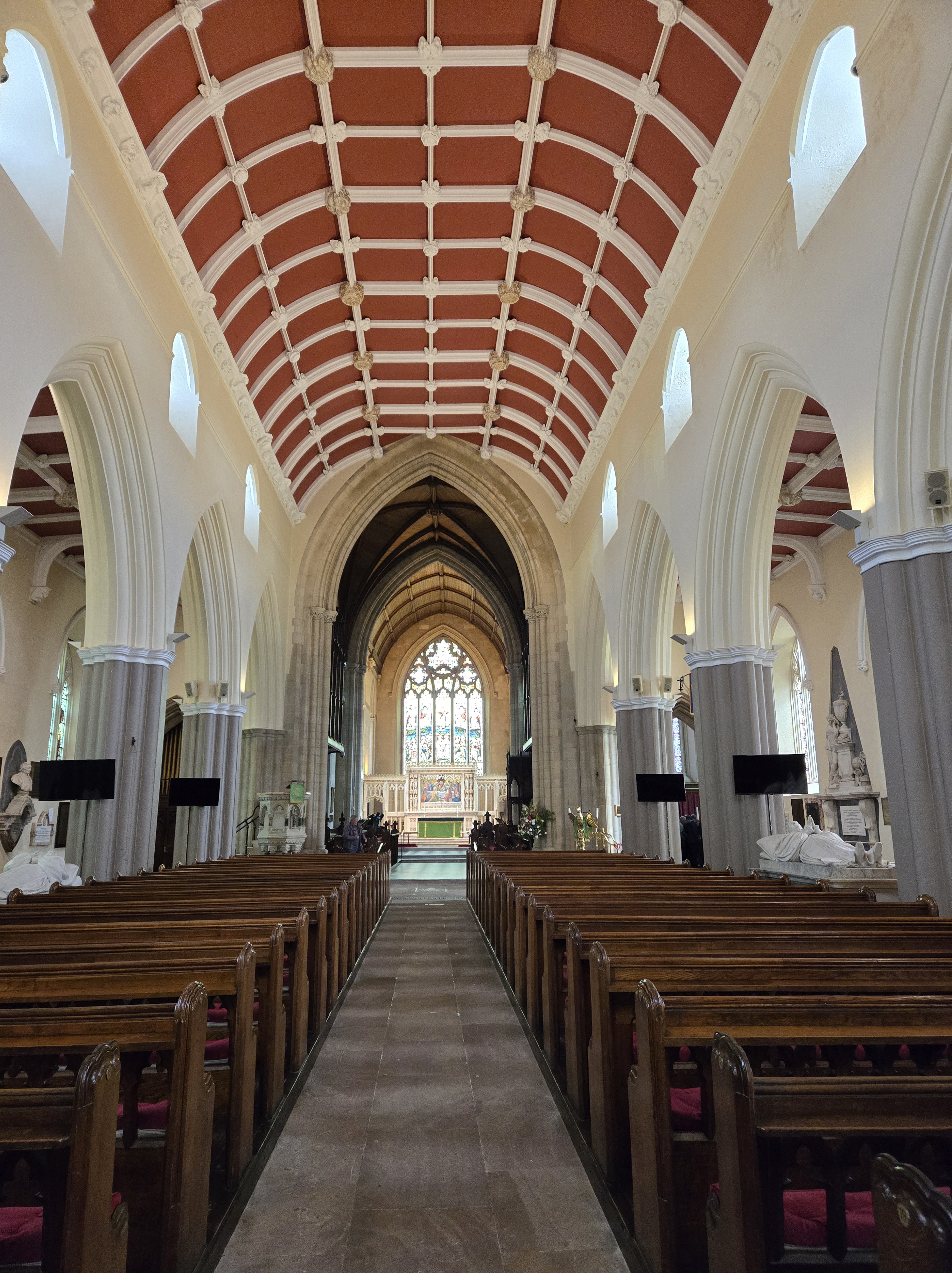
The long view of the Long Room, Trinity College.
The Long Room in the library, however, lived up to the hype! Currently, an art exhibit called “Gaia” is featured in it: a floating illuminated globe of the Earth that looks like it’s in outer space. Ironically, many of the books in the library are off the shelves. They’re being restored (and dusted, I suppose !)
We spent a lot of time in the Long Room, just soaking up the literary silence and beauty of it.
Day 5 found us still in Dublin. Next up: the famine statues, the emigration museum, and Cobblestone Pub.
We explored Dublin, feeling more connected to this land after our previous day’s adventure seeing where Russ’s ancestors lived. Our first stop was the National Museum of Archaeology. We saw golden artifacts and a huge dugout canoe crafted over 4,000 years ago (the Lurgan canoe). But the things I most wanted to see were the bog bodies.
Gallagh Man
If you’re not familiar, bog bodies are the corpses of unfortunate people who were either murdered or ritually sacrificed and buried in the boglands of Ireland and other countries. There are five bodies (or parts of bodies) on tasteful display in the (free to enter) museum. I’d only seen photos of them in magazines before. I wanted to see the bodies in person because I wrote a short story about a bog body, which will be featured in my book that’s slated for publication this fall. I’m in the middle of editing the manuscript and wanted to see if this museum experience would give me any new ideas.
I only took photos of two of the bodies: Gallagh Man and Clonycavan Man. Gallagh Man was a six-foot-tall, healthy man with reddish hair who lived sometime between 470-120 BC. He was found in County Galway, Ireland, in 1821 by laborers digging peat for fuel. The twenty-five-year-old was most likely strangled before being buried in the bog.
Clonycavan Man
Clonycavan Man was found in County Meath in 2003, also by peat harvesters. Alas, they were using a machine that cut the body in half, and only the upper torso and head remain. He was between 20 and 40 years old when he died sometime between 392-201 BC. At five-foot-two, he was shorter than Gallagh Man. One of Clonycavan Man’s most distinguishing characteristics was his hair. He had what may have been the first man bun! Perhaps it made him look taller. Scientists even discovered an ancient form of hair gel in his hair, made of plant oil and pine resin. The presence of this gel indicates he was fairly wealthy during his lifetime; it was made from materials found in France and Spain. His injuries suggest a grisly death, which may have been the result of torture. I’m not going to go into them here!
One theory proposed is that these men were failed kings or failed candidates for kingship who were killed and placed in bogs along tribal boundary lines. Their bodies served as offering to the goddess of the land to whom the actual king was “wed” in his inauguration ceremony.
I was particularly excited to see Clonycavan Man’s hair bun, since I gave the bog body in my short story a similar attribute. Seeing the bodies did not give me new ideas; rather the experience enforced what I’d already written. But it was very interesting to see them up close.
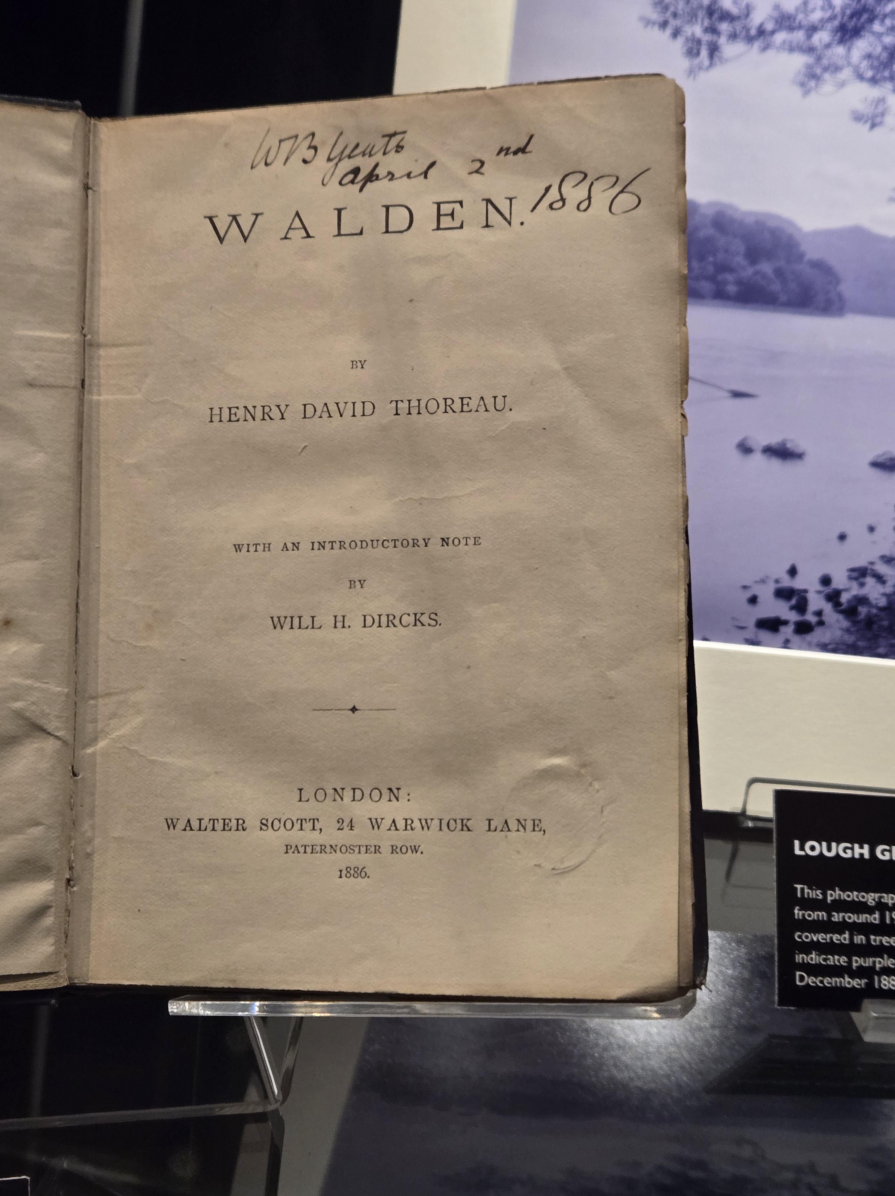
Next door to the museum is the National Library, which offered a free exhibit on William Butler Yeats, one of my favorite writers. We saw his copy of “Walden” and learned more about Maud Gonne, his muse who refused to marry him several times. I also learned that Yeats was heavily into spiritualism (think seances). I had not known that before.
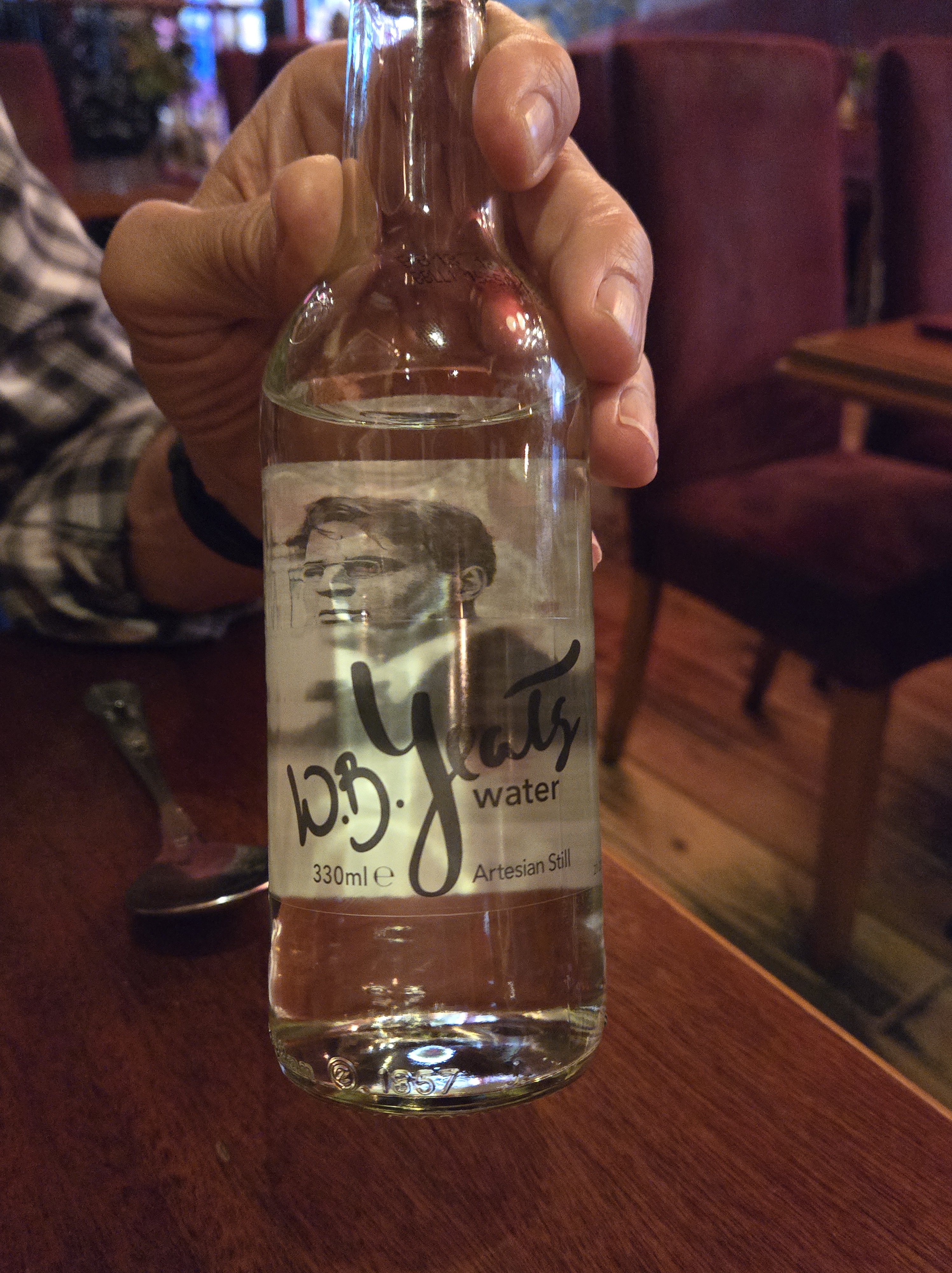
In an interesting coincidence, later that day, I ordered water at a restaurant. It came in a bottle sporting Yeats’s photo. The brand name was W.B. Yeats water. Imagine, naming a commercial brand after a writer! We don’t do that enough in the U.S. I will happily sell my name and likeness to anyone who wants to use it for commercial purposes. 😊
After touring the library, we walked through a drizzle to the famous Temple Bar. It’s known for its live music, ambiance, and large whiskey collection. It was too crowded and noisy, so we satisfied our curiosity with a mere stroll through it.
We had more Dublin adventures that day, but I’ll save them for the next post.
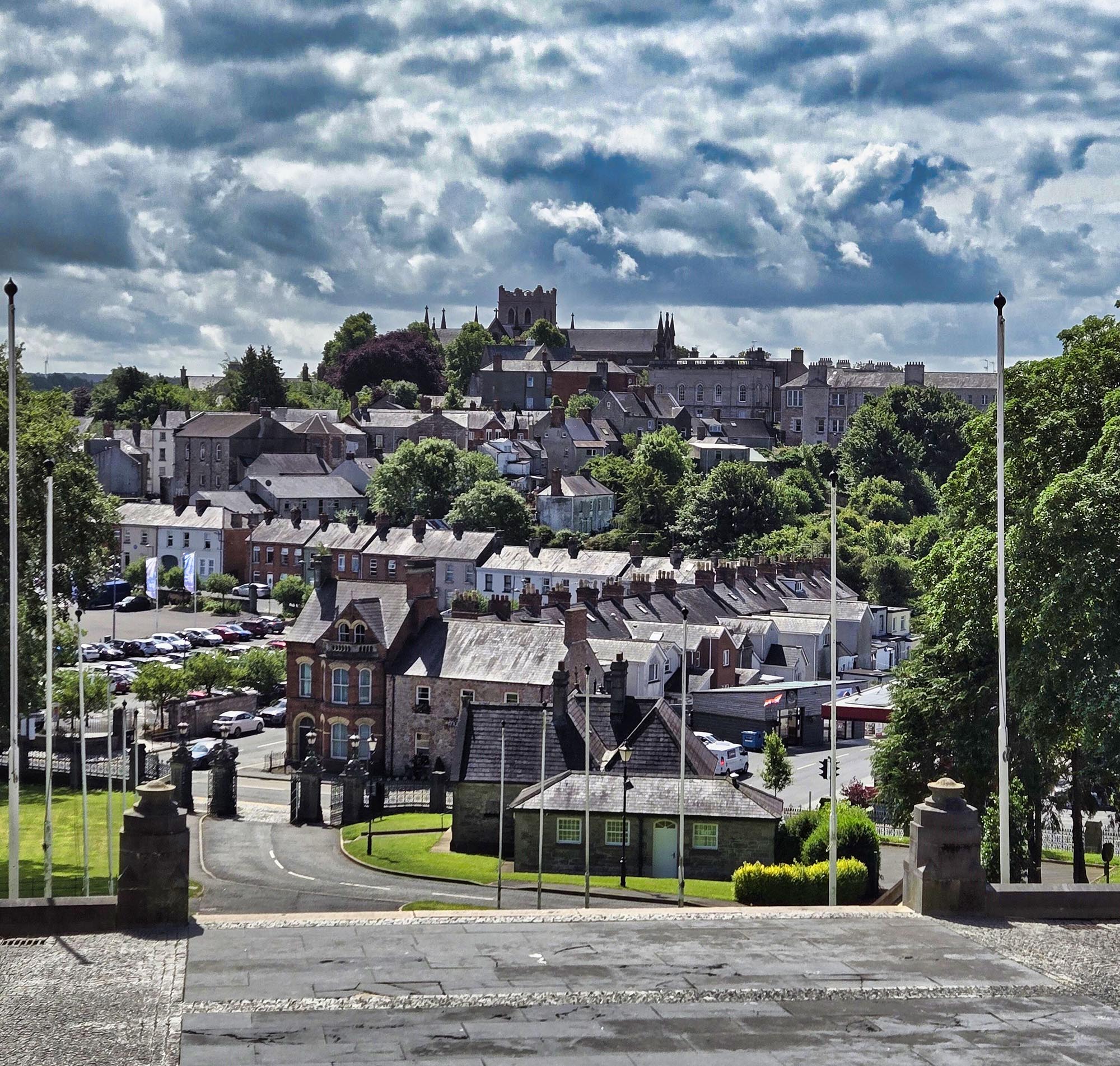
The town of Armagh and St. Patrick’s Church of Ireland Cathedral as seen from the steps of St. Patrick’s Roman Catholic Cathedral.
This day was a big deal for us. We’d been working for six months with My Ireland Family Heritage, a small, family-owned company that does genealogy research and tours. This was the day for our tour of the lands of Russ’s ancestors!
Our guide, Ian, picked us up from our hotel in Belfast. Our first stop was the small town of Armagh near where Russ’s ancestors lived. We had requested a visit to St. Patrick’s Cathedral there, but once we reached the town, we were surprised to learn that there are two of them! The oldest one (year 445) is Protestant and the more recent one (1840) is Catholic.
Armagh owes its association with St. Patrick to the old church, which is named St. Patrick’s Church of Ireland Cathedral. It stands on a hill overlooking the town. The hill (Ard Mhacha or Height of Macha) is where the city (Armagh) got its name. Before the church was built, it was a major ritual site and an ancient royal center. The Book of Armagh states that St. Patrick decreed that the Armagh church should have pre-eminence over all other churches and monasteries in Ireland, a position it holds to this day. The present structure was built in 1268 but it has been restored several times due to fires and worship needs.
Inside St. Patrick’s Church of Ireland Cathedral, Armagh.
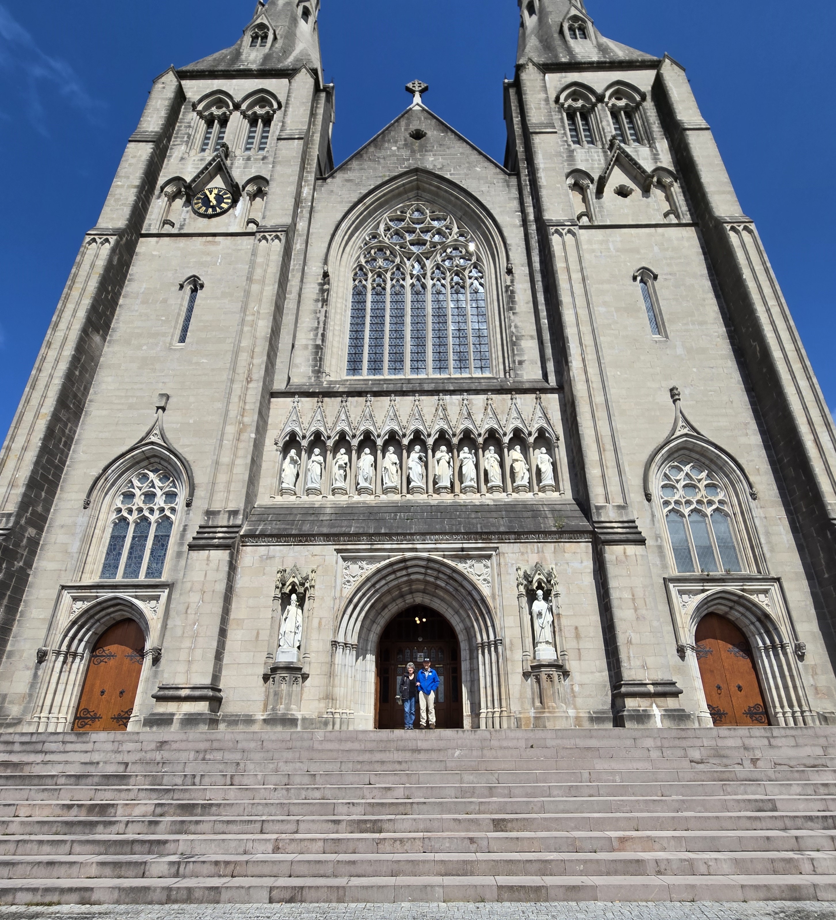
Across the way atop another hill is the other church, St. Patrick’s Roman Catholic Cathedral. It’s the seat of the Catholic Archbishop of Armagh. We could easily see it from the steps of the Protestant church. Of the two, the Catholic one is the fanciest, probably owing to its more modern construction.
Us at St. Patrick’s Roman Catholic Cathedral, Armagh.
Russ’s great-great-great grandfather James Henry Thornton lived just outside of Armagh in the small township of Foybeg. He came to Ireland from England with the unenviable job as a tax collector for Lord Lurgan (Charles Brownlow or Baron Lurgan), an Anglo-Irish politician who represented Armagh in the U.K. Parliament.
James Henry was married twice, but we didn’t know the names of either of his wives. James Henry had two sons, James and John, one with each wife. Besides being a tax collector, his occupation is recorded in church records as a farmer. Ian told us that Foybeg is known for the growth and weaving of flax into linen. It was the “cash crop” of the time, much like coffee is for Brazil today. So, he could have been a flax farmer.
His son James eventually moved to Australia. Russ is related to John, who was his great-great grandfather. He is described in family records as at least six feet tall. He loved horses, hunting and good whiskey, but hated work. He always carried a cane and had at least two dogs following him at all times. He was educated to teach school in Northern Ireland.
John married Jane Berry and they had eleven children. One of them was Russ’s great-grandfather, William John Thornton, who went by the name John Jr. After he emigrated to America, he married an Irish woman, Sarah J. Fox. She grew up near Foybeg.
Ian, our tour guide, outside St. Paul’s Church.
After lunch, Ian took us to St. Paul’s Church, which was where Sarah’s family worshipped and were buried. We saw lots of graves with familiar family surnames (Fox, Johnston, Berry) but did not come across anything significant. Inside, there was a “new” baptismal font on display. The old one was shoved underneath a spiral staircase. Could that have been used for Sarah Fox or her family?
The old baptismal font in St. Paul’s Church.
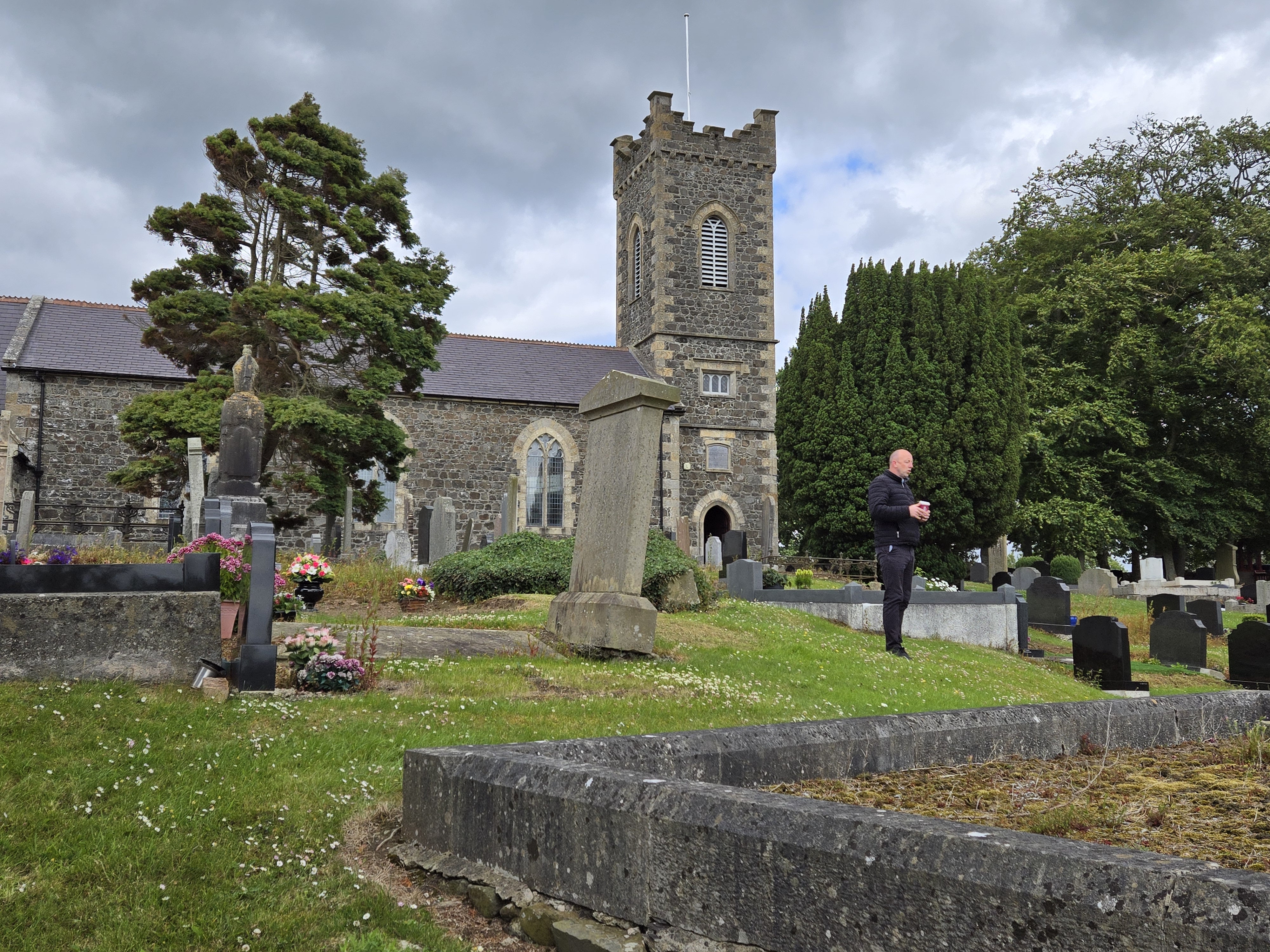
Our next stop was the Drumcree Church of the Ascension, where we hit the jackpot! This was the church (Church of Ireland denomination) where the Thorntons worshipped and were married/buried. The church is surrounded by cow pastures and apple orchards and even has an apple tree depicted in a stained-glass window.
The apple tree stained-glass window in Drumcree Church.
Besides the ancestral connection, Drumcree Church was significant during Ireland’s “troubles.” For several years in the 1990s, this Protestant church drew international attention as the scene of the Drumcree standoffs. Each year, the Protestant Orange Order marched to-and-from a service at the church on the Sunday before the 12th of July. Residents in the nearby Catholic district prevented the march from continuing through their neighborhood. Thousands of Orangemen and British loyalists gathered at Drumcree and violently tried to force their way through, but were held back by security forces, who built large steel and barbed wire barricades. These yearly “sieges” of Drumcree ended in the early 2000s.
Drumcree Church and graveyard
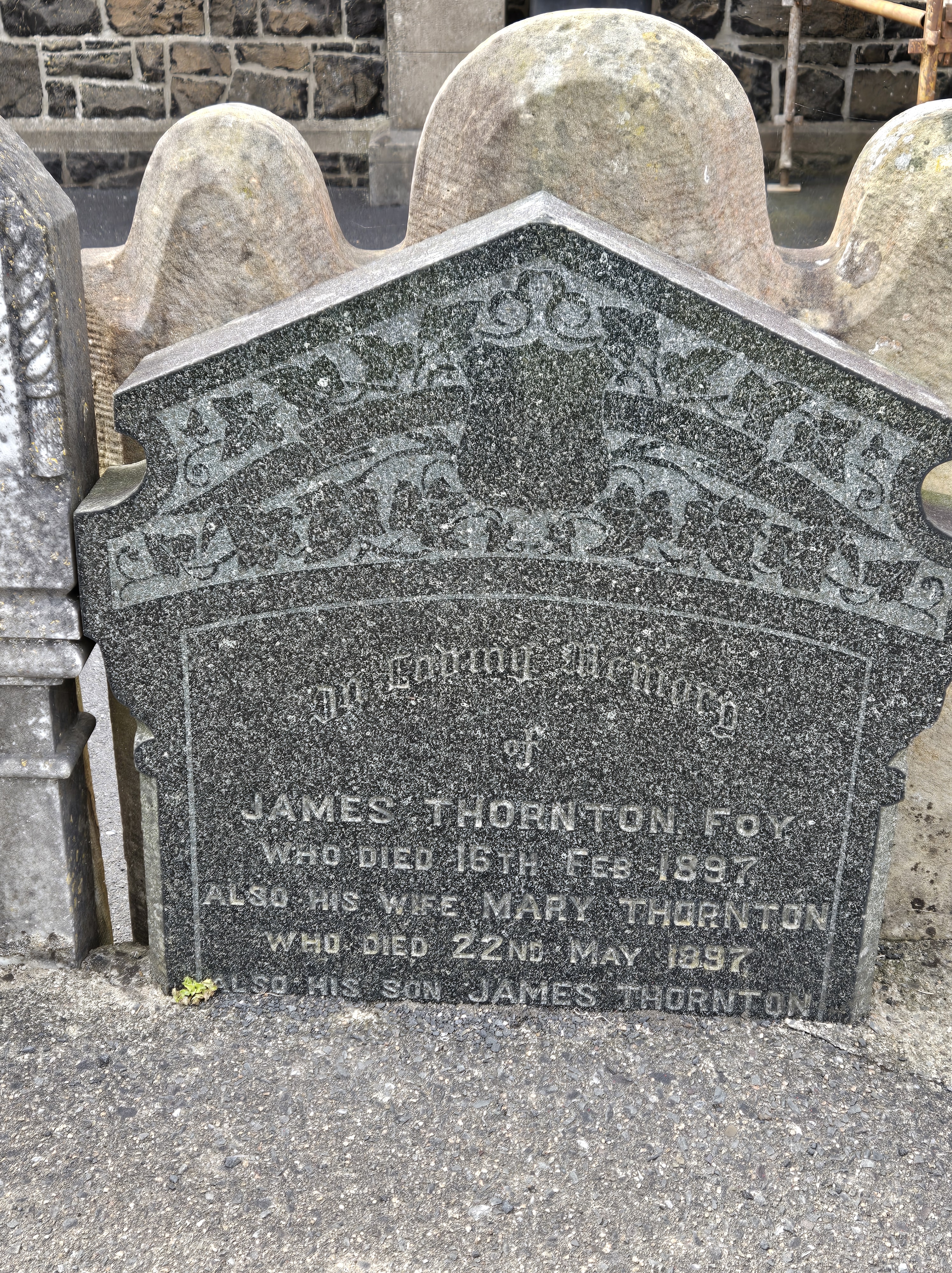
As we strolled around the graveyard, which smelled of manure from the cows nearby, we noticed a broken headstone propped up against the low stone wall that borders the yard. It was the headstone for JamesHenry Thornton and Mary. Mary must have been James Henry’s second wife! The last line on the tombstone says something about their son James Thornton, who was thought to have lived in Australia. Maybe he returned home to Ireland, eventually? The church member who let us into the building for a tour said that the stone must have been broken in the past, so that’s why it was leaning up against the wall and not over their gravesite. He said they do that instead of just getting rid of the broken ones.
Our exciting graveyard find!
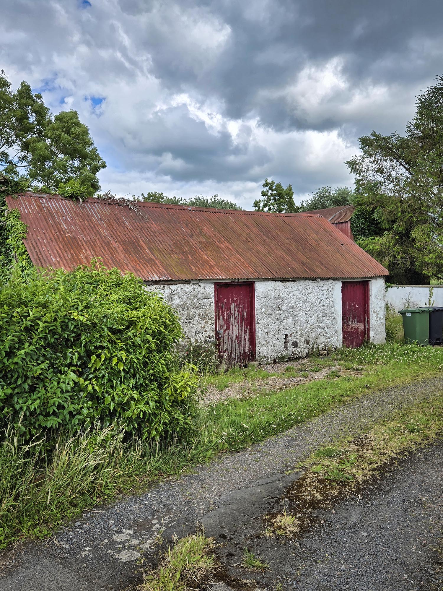
As if discovering this significant gravestone wasn’t enough, our talkative guide Ian next took us to the homesites of Russ’s ancestors. Two out of three weren’t accessible or there was nothing to see but an orchard, but the Thornton homesite was different! We peered down a driveway that led to a modern house. Between the driveway and the house was an old white building with red doors and a rusting metal roof. This was where Russ’s Thornton ancestors lived! It looked more like a shed or a barn now than a home.
The Thornton Family home in Foybeg Township, Ireland.
We only had time to take a few photos before Ian wanted to leave. You see, he is a Catholic from the Republic of Ireland to the south. We were in Northern Ireland, which is mostly Protestant. He did not feel comfortable hanging out in rural areas for fear of a confrontation. (People can tell where he’s from by the license plate on the van.)
Once we were back in the van driving away, Russ said a lady had been out in the yard. I would have loved to have had the chance to speak with her to see if she knew anything about the past inhabitants of her place, but I did not see her when I was taking pictures of it. Russ took the geographic coordinates of the location, so perhaps, if we ever return, we will have more time to explore and chat. Russ said that this was his favorite part of the tour.
As the ancestry book that the tour company put together for us says,
What was once a home where children played a hive of activities stands quiet now, a home for spiders and field mice. In the corner of the eves an owl hoots every evening . . . People lived and died in this cottage. Its walls could tell you stories, happy and sad. Children grew up here, some stayed near, and some traveled far and wide to the other side of the world. They packed their memories to start a new life, new beginnings, and new memories, leaving this little cottage to nature.
Russ’s great grandfather, William John Thornton emigrated to the U.S. He settled in Manchester Connecticut and married Sarah. They had four children. At the time of his marriage, William John was employed as a “velvet finisher.” He also worked as a coachman and a laborer later. Unfortunately, William John was an alcoholic. He died in 1917 from freezing to death in a drunken state in a roadside ditch. Sarah lived until a ripe old age, dying in 1964.
Tour over, Ian drove us to Dublin, the site of our next adventures!
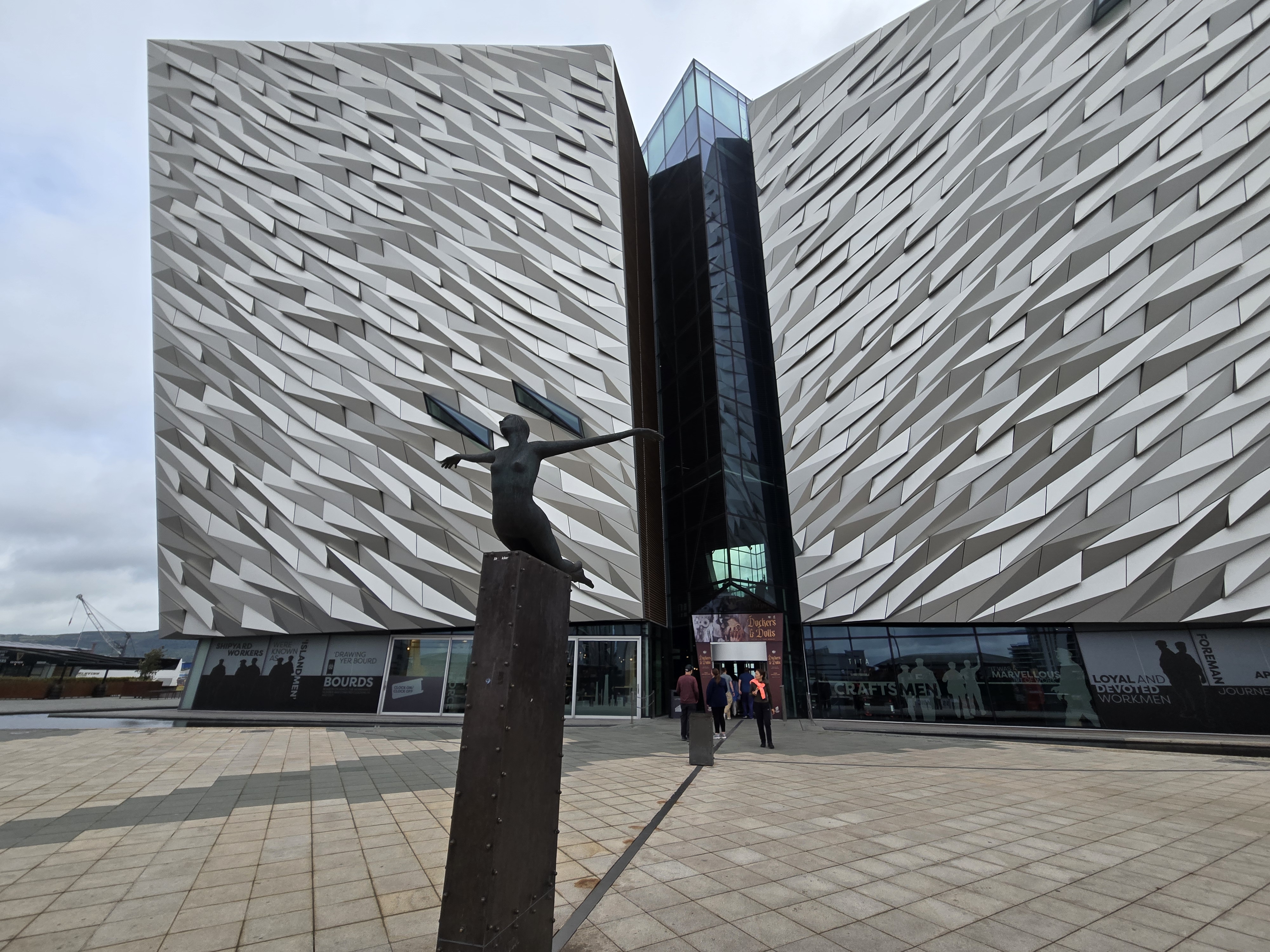
Belfast was where the Titanic and its sister ships, the Olympic and Britannic, were built. We’d heard that because of this, the Titanic Museum was mainly about how the ship was built and not so much about the sinking, but we found this not to be true.
I was thankful for that because, of course, the sinking is what the Titanic is known for. Although I don’t care to watch the movie version of the sinking ever again (all that death made me ill!) I was interested in seeing the museum version of the tragedy.
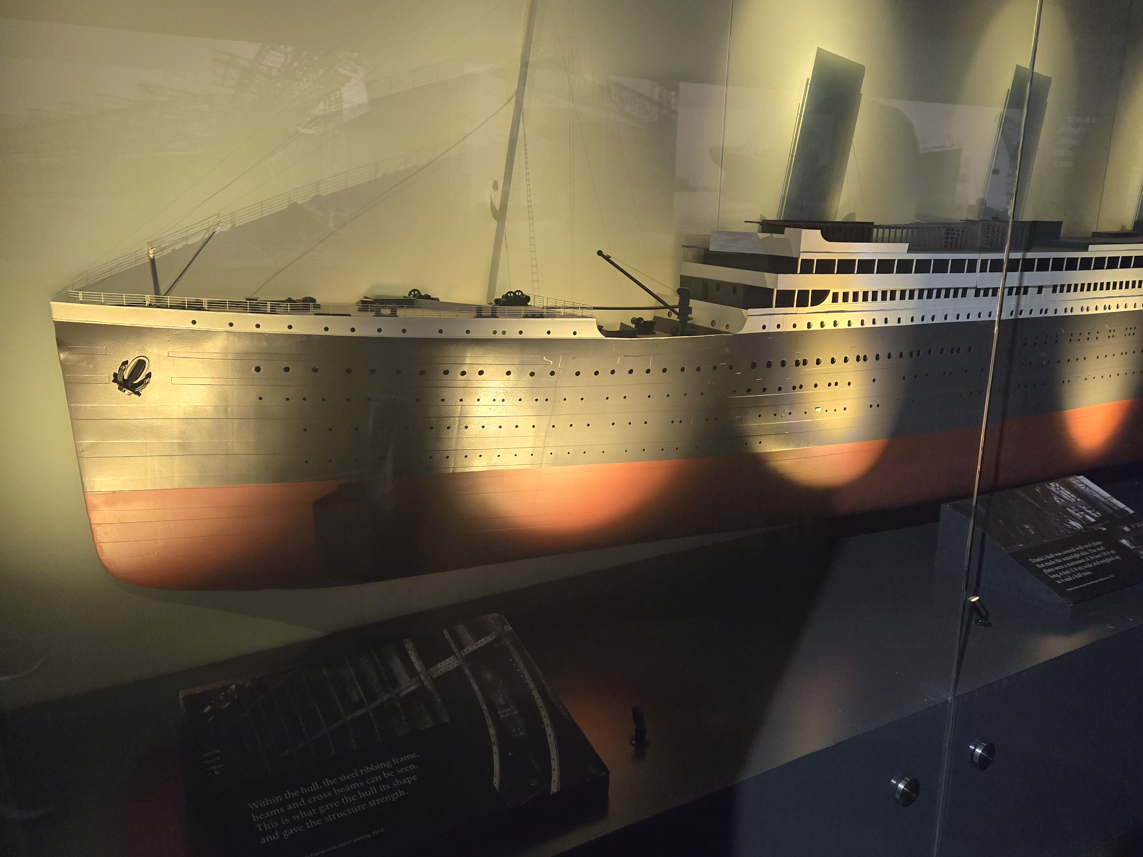
A model of the Titanic in the Titanic Museum
The museum was well worth the entry price. Pre-booking of tickets is required. The displays were built in various ways that appeal to all types of learning: audio, visual, reading, entertainment, experiential, and probably a few others I don’t know about. Talking holograms of passengers and crewmembers offered interpretation along the way. There were models of the Titanic, and even a ride in these funky, boxy cars that took visitors through the experience of building the ship. Outdoors, the yard where the Titanic and other ships were built is visible from the museum.
A replica of a first-class state room on the Titanic, complete with hologram passenger and staff member.
My favorite part were the displays that dealt with discovering the ship’s resting place at the bottom of the North Atlantic. Visitors can walk over a glass floor that simulates walking above the wreckage on the ocean’s bottom. That was so cool!
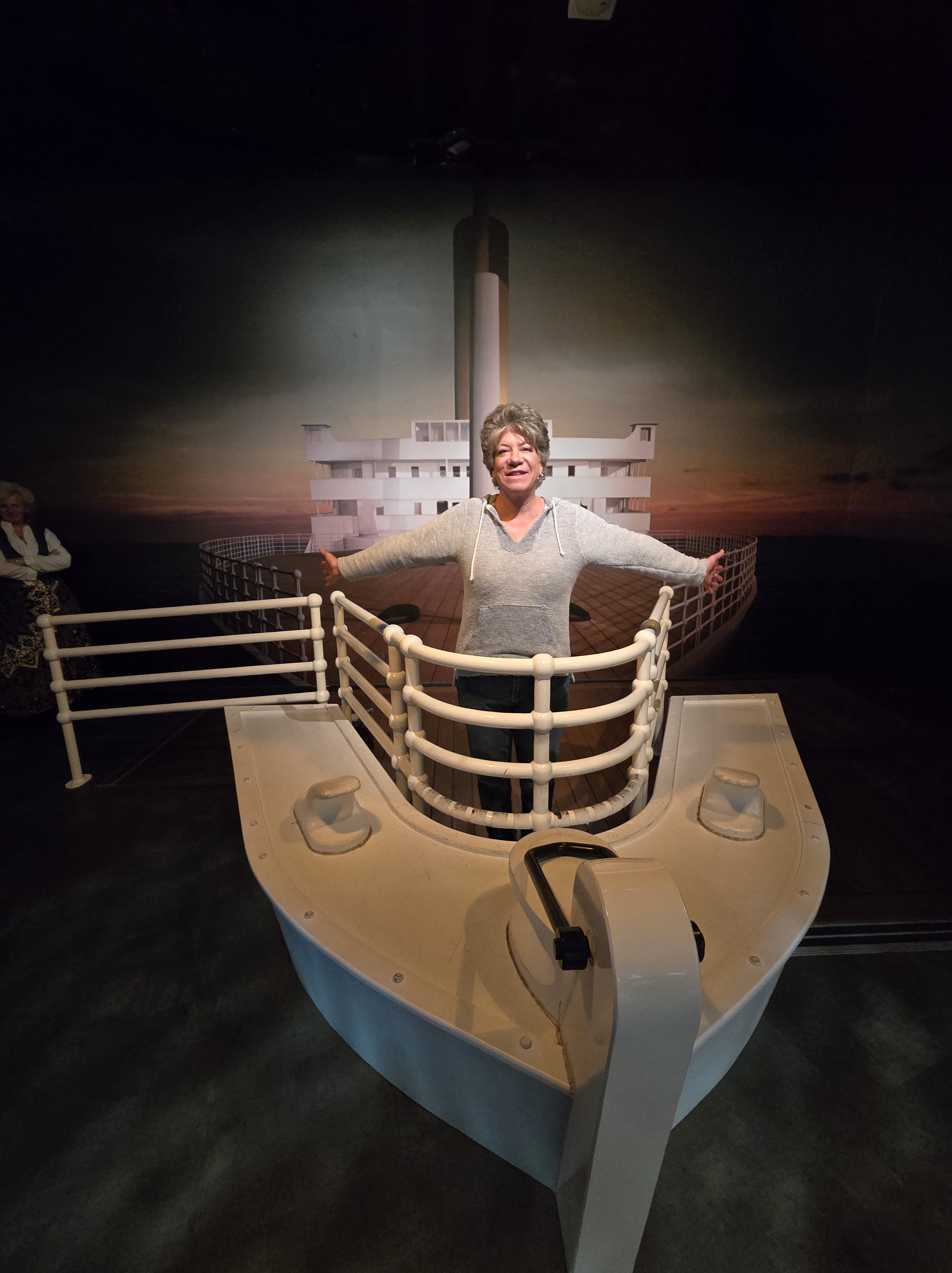
Marie, striking a typical Titanic pose.
After our tour, we popped into the museum’s Galley Café, which had food just about a delectable as a first-class passenger’s on the Titanic. I ate a wonderful chowder and topped it off with trifle for dessert. Trifle is a parfait made with cake cubes, vanilla pudding combined with whipped cream, and interspersed with berries and peaches. The café’s trifle was not as good as the one I make, but I wasn’t going to complain. I was impressed that they even offered it as I’d never seen it on a menu before (especially in the U.S.).
Afterward, we meandered outside and toured a ship in dry dock called the Nomadic. Like the Titanic, it was built by the White Star Line and was the tender ship for the Titanic. This means it ferried passengers and supplies to it. The Nomadic is the only surviving White Star Line ship left. Entry onto it was included in our ticket price for the museum. That was fascinating to see, especially a few pieces of original oak paneling that are left in the women’s bathroom sitting room, and how the various classes of passengers were kept separated.
The Nomadic, Titanic’s tender ship.
After that, we hopped onto the Maritime Trail in a light drizzle. It goes right past the museum, so a stroll along it was a no-brainer. In addition to interpretive signs about the city’s maritime history, there were “Game of Thrones” stained glass displays. The TV series was filmed in Ireland.
A cute seal that was on the Maritime Trail.Look at those eyes!
As the drizzle increased and our feet got sore, we tried to order a cab to take us back to our hotel but had no luck. The problem was Shania Twain. The singer was in town and all the cabs were booked by her fans. We trudged back to the Titanic Museum and were able to nab a cab that was waiting in front for passengers. Our driver said that Shania is of Irish descent, along with Taylor Swift and Mariah Carey, so they’re all big deals in Ireland.
The main reason we decided to visit Ireland was to explore Russ’s heritage. Like the famous singers, Russ is of Irish descent (as well as French and German). His great-great-great and great-great grandfathers and grandmothers lived there, and the female line goes back even farther. In the next post, I’ll describe what happened on Day 3, which involved a genealogical tour to his ancestral homelands outside of Belfast.
Also, one of the main reasons we were visiting Scotland later on our trip was to investigate my ancestral heritage. Since the last time I was in Scotland eight years ago, I discovered (thanks to my cousins) that we’re related to Robert the Bruce, first king of Scotland. (He is my great-grandfather to the 21st power.) While we were backtracking to the museum in the rain, one of our plans on that account came to fruition. I’d been trying for months to book a tour of Broomhall House outside of Edinburgh, which is the family home of the Bruces, and it was only recently opened for public tours.
We got news that those plans were a “go!” That lightened the misery of walking with tired feet in the rain. We only hoped that our luggage would finally arrive so that we’d have something nicer to wear than blue jeans and stinky underwear to Broomhall.
We capped off our evening with supper at Ryan’s Pub. This was a second visit for us because it was within walking distance of our hotel and the food and drinks were grand! I was introduced to a whisky sour there (topped with a sprig of mint), and it has quickly become one of my favorites. As if that weren’t good enough, when we arrived back at our hotel, our luggage was waiting for us!
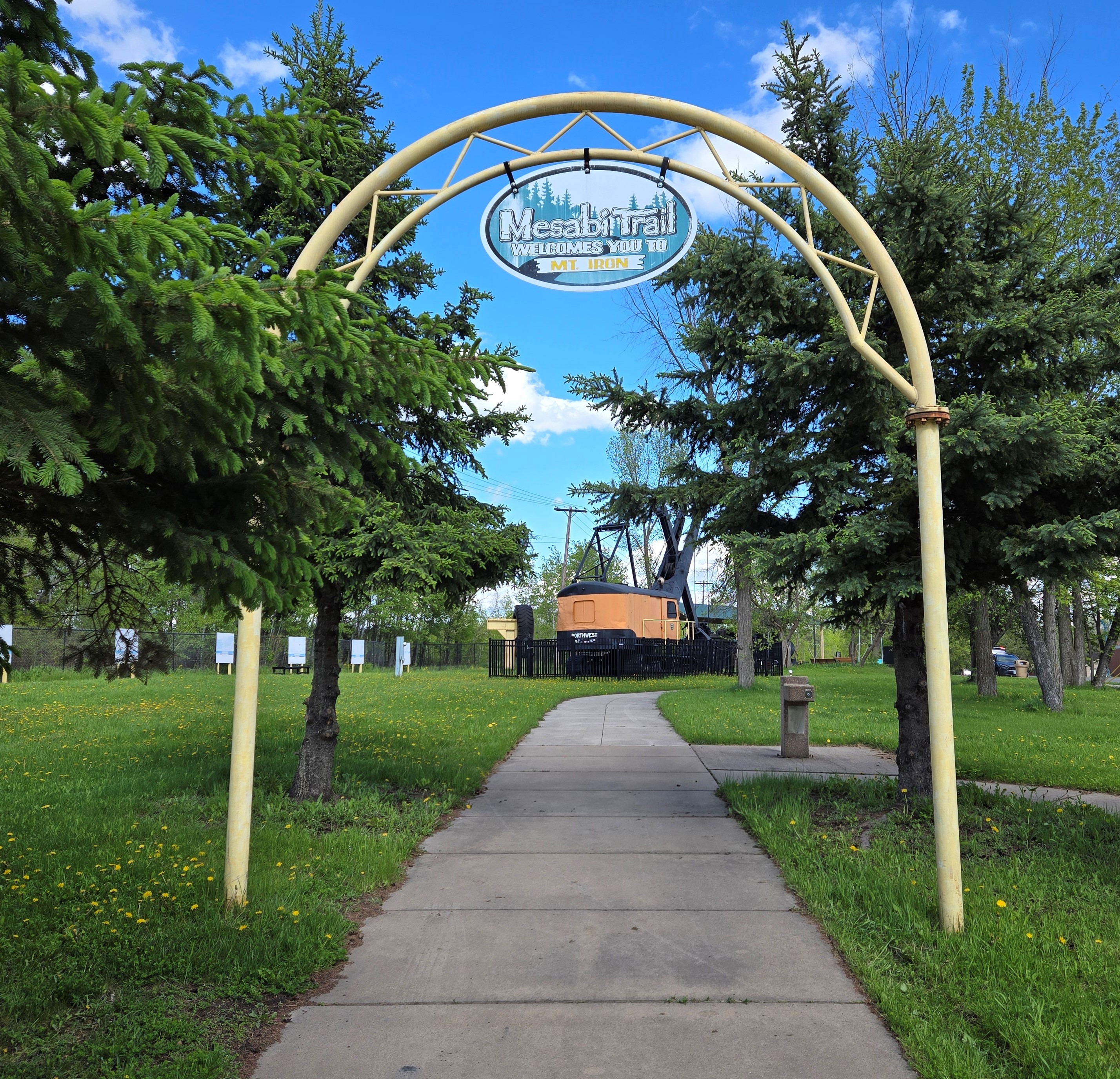
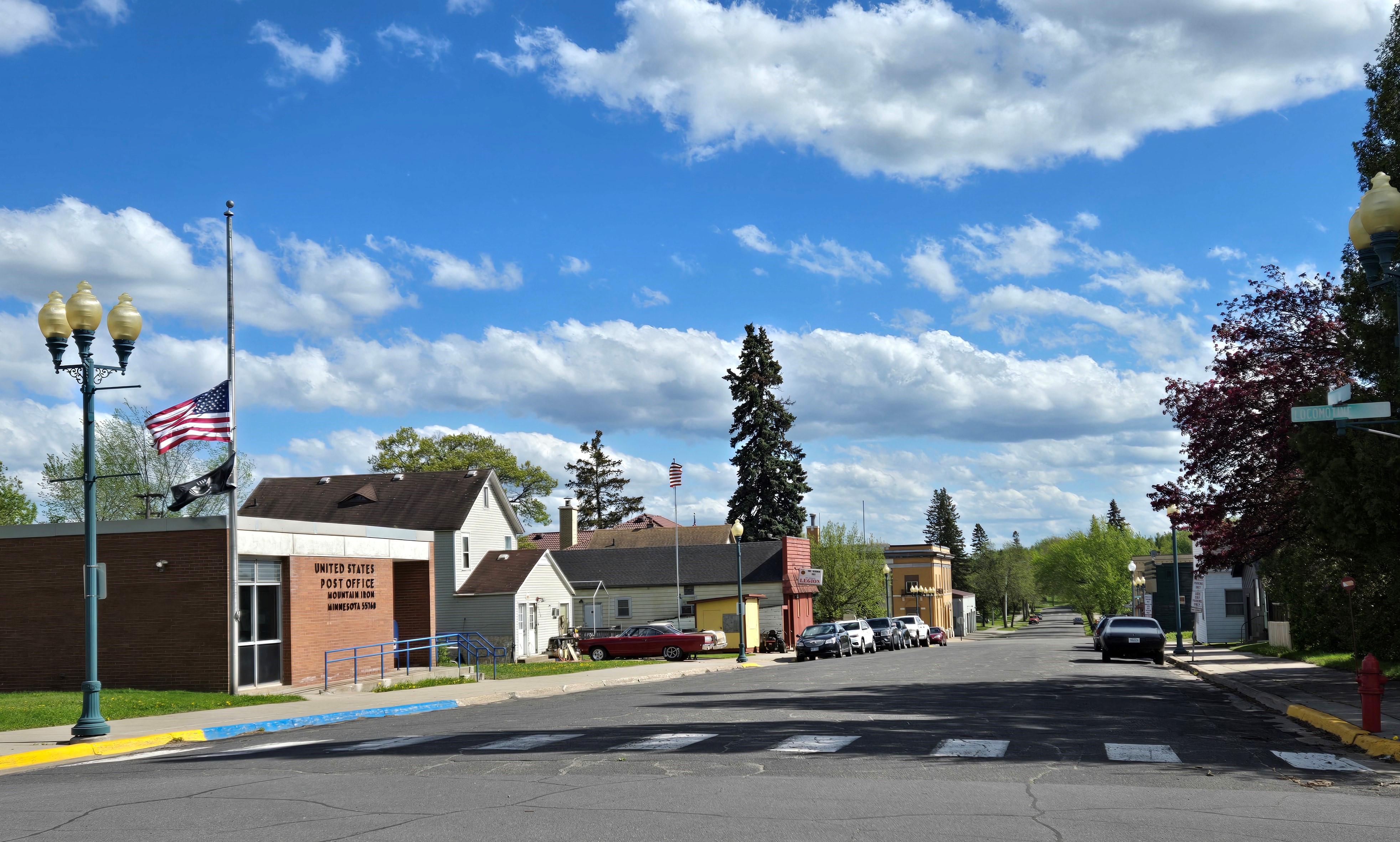
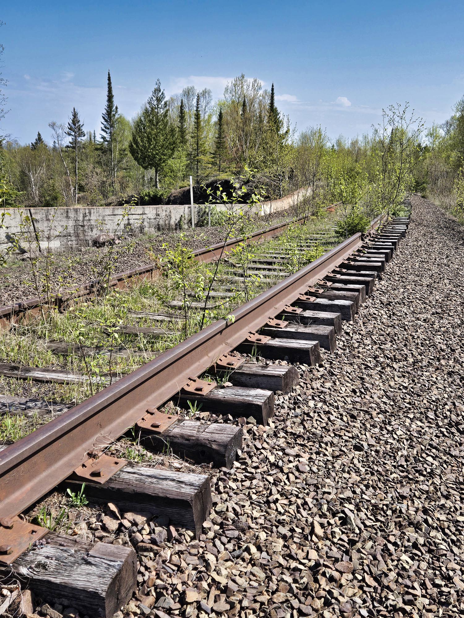
The beginning of the Mesabi Trail in Mountain Iron.
In our continuing quest to bike different sections of the Mesabi Trail in northern Minnesota, Russ and I meandered over to the small mining town of Mountain Iron last weekend. We planned to pedal a 6.5-mile stretch between there and the neighboring town of Kinney. (Round-trip, the distance is a little over 13 miles.)
Mountain Iron is known as “The Taconite Capitol of the World.” It’s the site where iron ore was first discovered on Minnesota’s Iron Range. The mine is no longer in operation, but during the 30 years it was open, 52 million tons of iron ore were shipped to various steel mills in places like Michigan and Illinois.
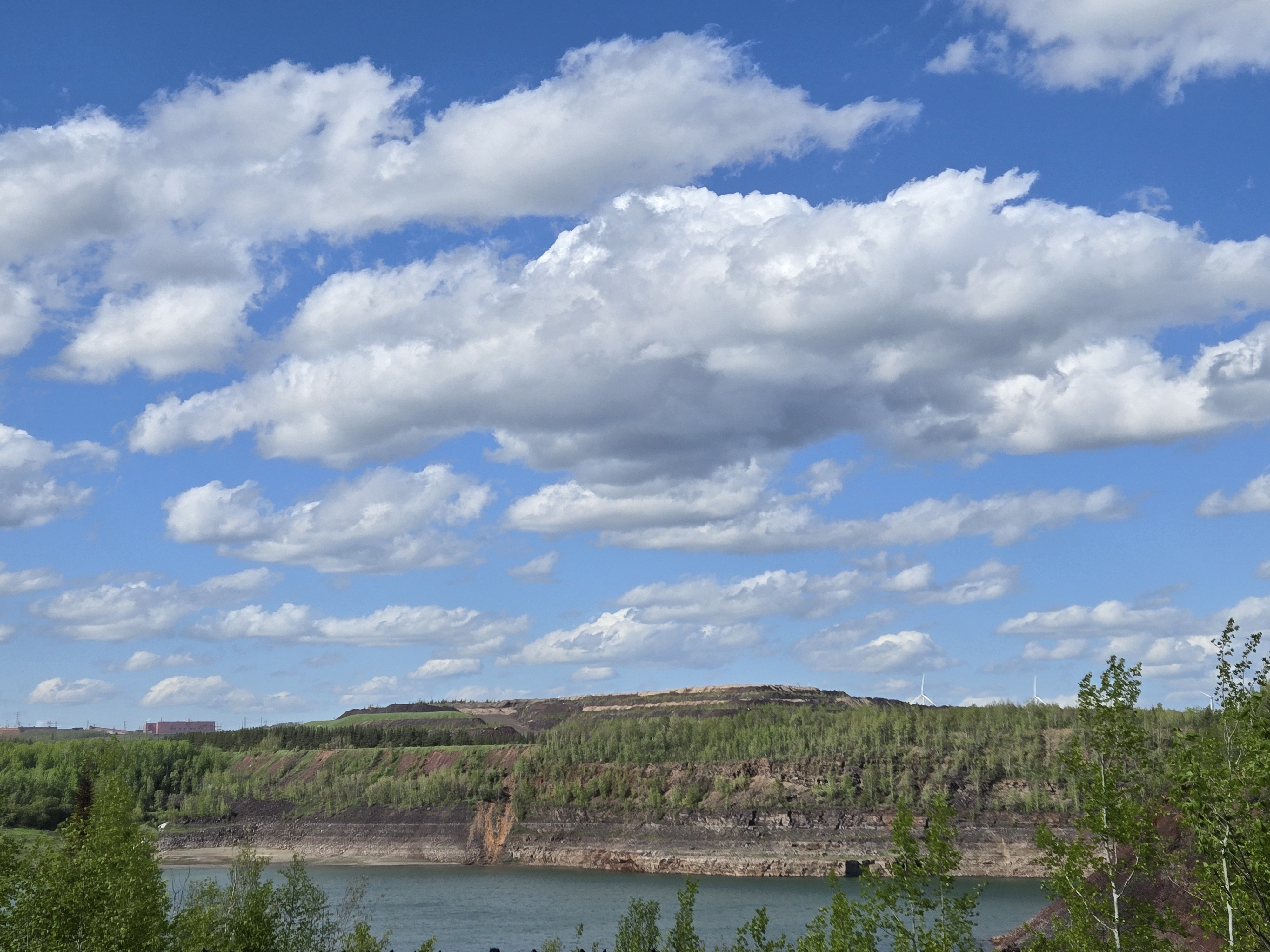
The landscape and town bear the scars of this industry. A huge mine pit filled with turquoise water is visible from the small city park where the trail begins. As we biked toward Kinney, we passed ghostly remnants of homes and businesses that had been moved to make room for mining operations. Cement house pads and neglected lilacs provided testament to the abandoned homesteads.
The open pit mine in Mountain Iron. You can almost make out the wind turbines on the hill to the right.
These days, instead of iron ore, Mountain Iron is known for wind energy. Several turbines spin on far hills. They are part of the Taconite Ridge Wind Energy Center – the first commercial wind center in northeastern Minnesota. An interpretive sign in the park says, “In ideal wind conditions, 10 turbines can collectively capture the wind and convert it into 25 megawatts of electricity – enough to power 8,000 homes on an annual basis.”
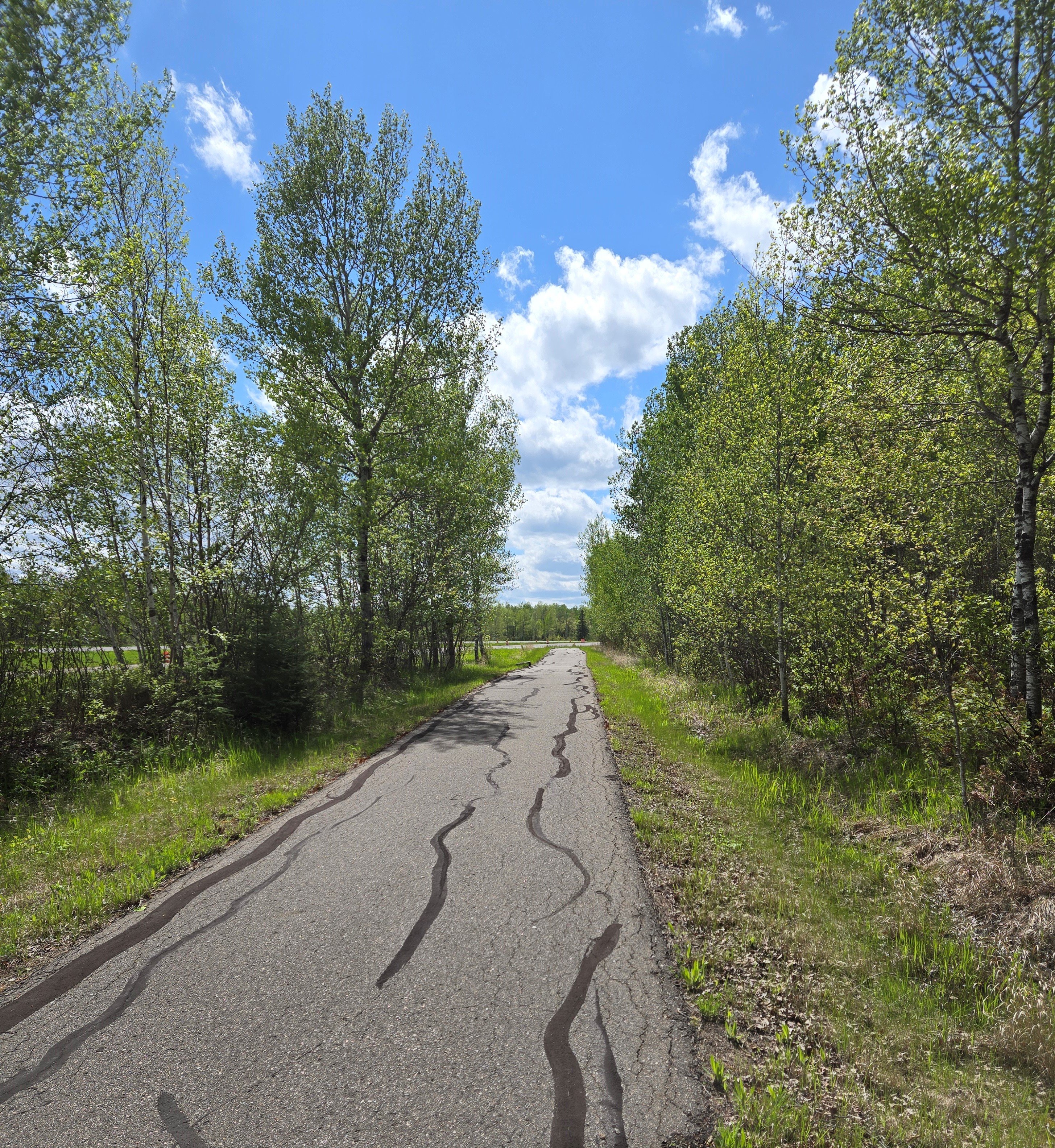
A typical section of the Mesabi Trail.
Compared to other sections of the trail we’ve biked, this was more civilized. Once we passed the abandoned neighborhood, a few occupied homes lay along the trail. Huge grassy piles of mining tailings lined the horizon. Although a sign along the way says that tailings are not a health hazard, I don’t believe it! We saw a lined basin where it seemed like water was being pumped from the base of the piles. I couldn’t find any info about that online, but I am hoping it’s so the water can be collected and treated before being released into the environment. For much of the way, the trail parallels a highway, although it’s often hidden from view by trees.
A couple of hills dot this section of trail, but nothing too onerous. When you first near the highway, there is a hill with a curve at the bottom. Bikers coming the other way also have a downhill before the curve, so beware of that. Two downhills lead over small bridges with culverts underneath them. The culverts each form a bump. I almost caught air on one of them!
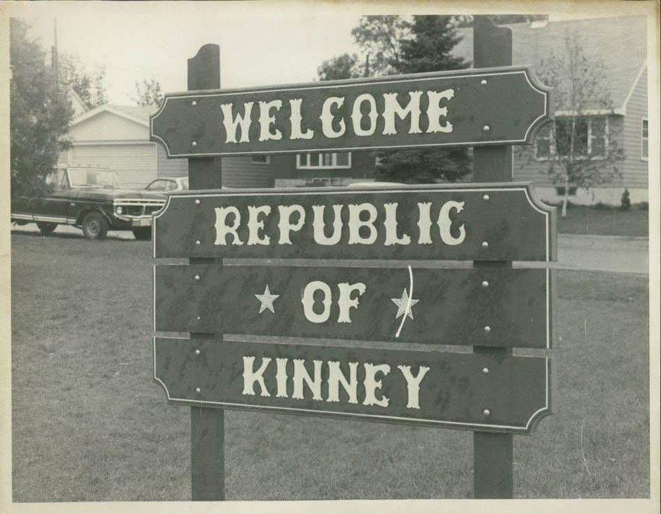
We saw one bicycling family and a few other small groups. When we reached the turn off to Kinney, we did not feel the need to explore. But now, after reading more about the town, I wish we would have. Kinney once voted to secede from the United States and become a foreign country. This bold yet tongue-in-cheek action was taken to draw attention to the small city’s dire water system situation.
According to an account on the Mesabi Trail website (linked above via “Kinney”), the system was “failing so badly that the fire department had to watch buildings burn to the ground due to lack of water pressure. That year the term ‘The Kinney Brown Shirts’ was coined because all clothing washed with detergent that included bleach turned brown because of mineral deposits in the water.
“Replacing the water system far exceeded the budget of the small town, so the city exhaustively searched locally and nationally for assistance. The resulting volume of paperwork led to the city’s motto of ‘File in Triplicate.’ The city attorney commented that it would be easier to get money if the city seceded, waged war with the union, quickly lost, and then asked for foreign aid. The joke took root, and the council voted unanimously to secede on July 13, 1977, and a certified letter was sent to U.S. Secretary of State Cyrus Vance.”
A sign with the new name of the town of Kinney after it seceded from the USA and declared itself a foreign republic. Image courtesy of the Mesabi Trail website.
The secession gained international publicity and from that, the city eventually received grants to replace their water system.
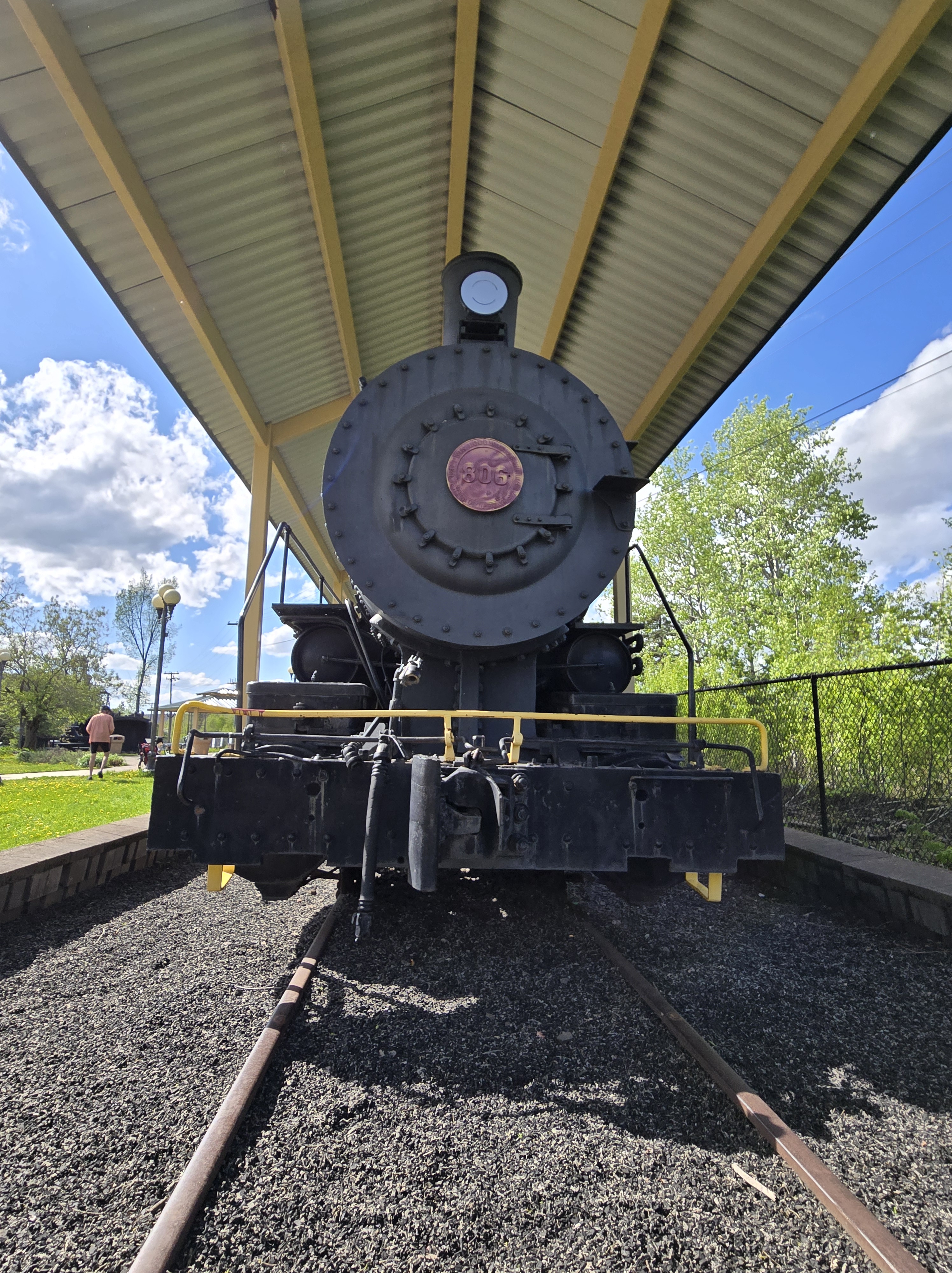
Our way back to Mountain Iron seemed easier than the ride out. I’m not sure if that was from the tailwind or the topography, but biking back was a breeze. Ride over, we spent time exploring the various pieces of mining equipment in the park. This included an old locomotive, which, no doubt, used to haul taconite to ships waiting for it on Lake Superior’s shore. Another group of bikers that we passed on the trail arrived and we chatted a bit. They were from St. Paul and were biking the entire trail, staying in hotels overnight.
Downtown Mountain Iron.
That’s it for our experience with this section of the Mesabi Trail. Maybe next time, we’ll start from Kinney to experience this plucky little burg.
The locomotive engine in the Mountain Iron city park where the bike trail begins.
Update: 8/31/25
Well, it took a while, but we did start cycling from Kinney. This hardscrabble town is composed mostly of trailer homes. Not that there’s anything wrong with trailer homes. I’m just not used to seeing so many of them near the center of town.
We biked from Kinney to Buhl, which is only 4K. From there we rode toward Chisholm, a section we’ve ridden in the past, but I don’t think I blogged about it. The most scenic spot was the Stubler Mine Pit Beach, which looked like a good spot for swimming. A bunch of folks were doing just that during our Labor Day Weekend ride.
The beginning of the trail was wooded, but then much of it follows an abandoned roadway. The most scenic part of the section past Buhl was the City of Chisholm sewage plant. Thus, this addendum and not an entire blog post.
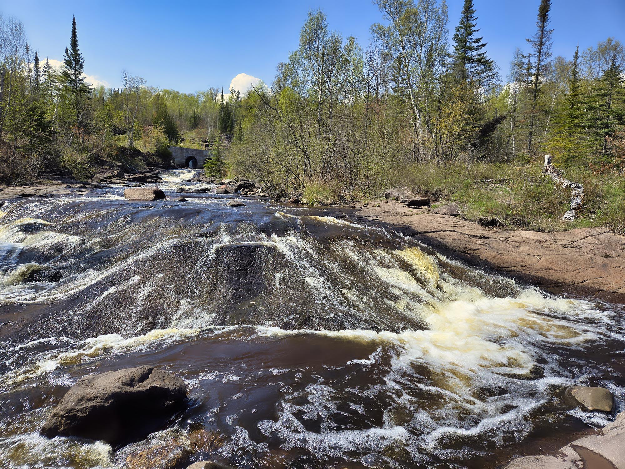
We’ve been driving up and down Highway 61 on Lake Superior’s North Shore more than usual lately to deliver and retrieve my photos that were on display in Grand Marais. On one trip, I noticed a river that flowed underneath the highway. No sign sported the river’s name. Looking landward as we whizzed past, I spotted a double culvert bridge about a hundred yards away that the river flowed through. Was that a waterfall behind one of the culverts? The scene was intriguing and not one I’d ever seen photographed by established North Shore photographers. I made note of the location and vowed to stop on our next trip.
That “next trip” was last weekend. On our way back to Duluth from Grand Marais, we stopped near the mystery river, which is near Taconite Harbor. The harbor’s a place where mining companies used to load taconite (iron-ore pellets mined and made on Minnesota’s Iron Range) from rail cars into ships bound for steel-making plants in Michigan and Illinois.
We parked our car in a driveway entrance that was blocked by a gate overgrown by saplings. Although the driveway had a fire number on it, that gate obviously hadn’t been opened in years, so we weren’t too worried about blocking access.
We walked across the highway and, as cars rushed past, took a short jaunt to the river. We hopped the guardrail in a likely looking spot and soon found a faint game trail. The trail also could have been made by anglers. We found out later that part of the river is considered an “Aquatic Management Area” allowing angler access by the Minnesota Department of Natural Resources.
Two Island River, see the culverts upstream?
It’s spring and we’d had a heavy rain recently, so the shallow river splashed with gusto over reddish-gray rocks. I clambered along the banks, camera in hand, taking photos at spots that offered a good vantage. But I was impatient to get to my goal: the double culvert up the hill, and that waterfall behind it.
Russ went ahead while I took photos. When I caught up to him at the railroad bridge with the culverts, he’d had time to look up the name of the river on his phone. We were looking at Two Island River, a 15-mile waterway. There’s not much info out there about it, but Wikipedia says the river is named for two lake islands near its mouth.
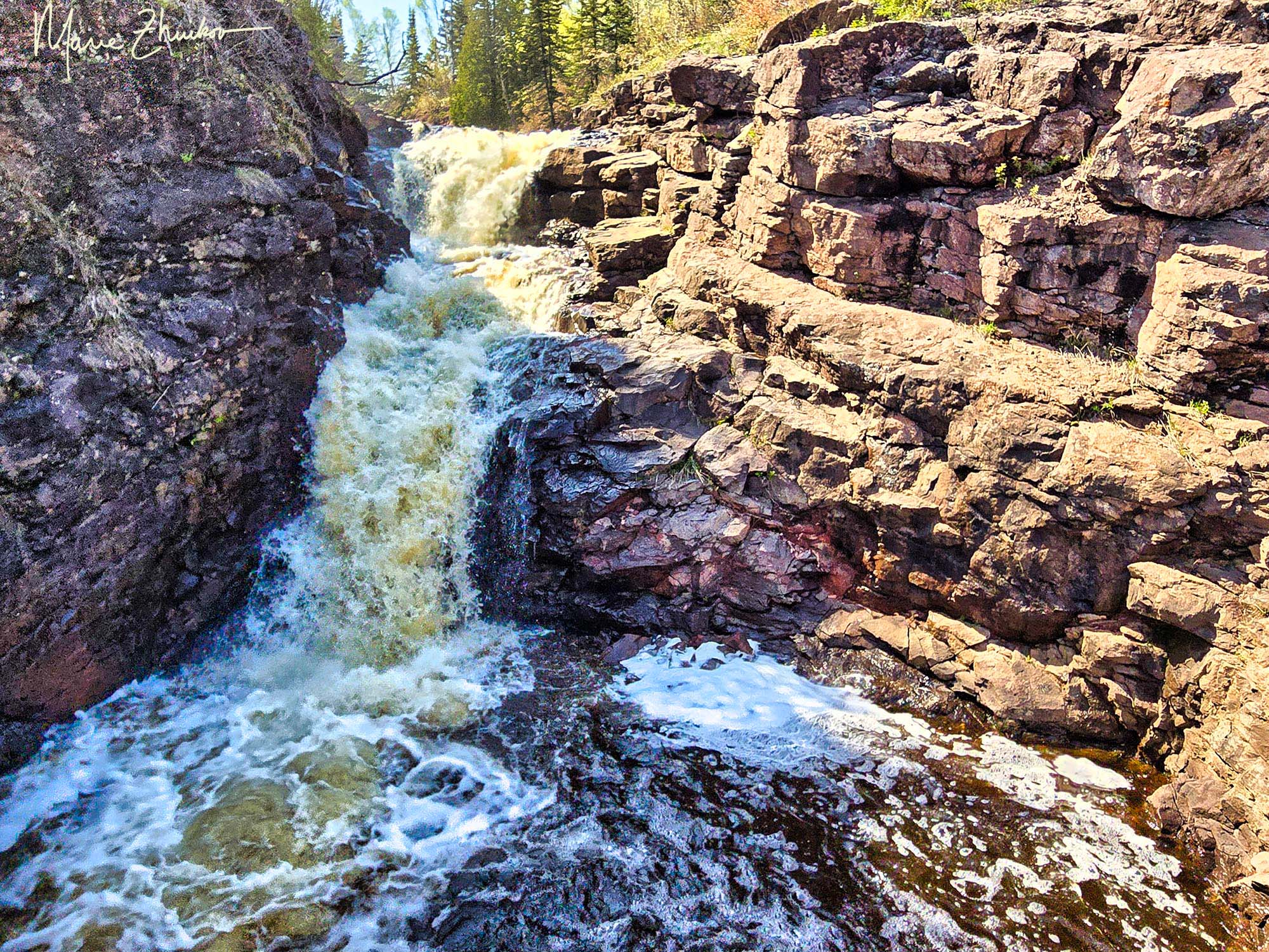
As you can probably tell, there was a waterfall behind the culverts. A very nice one, too. The steep angle of the sun and rising mist from the falls made for some blurry spots in my photos, but I managed to get a few images without amorphous blobs floating around in them.
Two Island River Waterfall (in color)
Waterfall appreciation over, we investigated the railway bridge. Like the driveway gate, the railroad was overgrown with saplings and obviously hadn’t been used in years. Research I did while writing this post uncovered the facts that the railway was named the Cliffs Erie Railroad. The last train operated in 2001, but after that, cleanup trains, which collected leftover chips and pellets from the mines, operated until 2008.
A bustling little town was situated near the Two Island River, probably accessed through that overgrown driveway where we parked. Taconite Harbor, Minnesota, was a mining town built by the Erie Mining Company. In 1957, twenty-two prefabbed homes were trucked into a several block area near the lake. The little community even had a fire hall, community center, playground, and baseball/tennis courts.
It seemed like a 1950s ideal community. Seventy-five children grew up there and probably played along the river’s banks. In the 1970s, families were driven away by noise pollution and health concerns about the taconite dust that blew off the rail cars and from local stockpiles.
The steel industry lull added another blow in the 1980s and by 1988, the last resident had left the little Taconite Harbor town. In 1990, the remaining homes and buildings were packed up and transported away by trucks. Driving past the site, I recall seeing only empty asphalt streets, home foundations and streetlights. Nature has reclaimed much of the area, but town remnants remain. It’s truly a North Shore ghost town.
Russ and I didn’t have time to investigate the town site ourselves, but there are many good images of it on the internet. “Forgotten Minnesota” has some good ones.
The Cliffs Erie Railroad tracks that cross the Two Island River bridge.
The history of this area also includes an event that I narrowly escaped. It’s an involved tale so I’ll start from the beginning. In 1957 when the little town of Taconite Harbor was being formed, the mining company also began dumping ash from its nearby coal-fired power plant near the river and the town. I’m not sure it was illegal at the time, but it probably was as time went on. The dumping continued until 1982 and the pile covered 27 acres.
On the morning of July 28, 1993, I drove up the highway in a pale green government car through a heavy rain on my way up to Grand Marais for my job with the Forest Service. Later that day, thanks to the rain and the fact that the mining company had been dumping excess water from a coal stockpile onto the ash heap, the pile became saturated and it liquified in a rare phenomenon called “static liquefaction.”
The heap collapsed and flowed downhill, covering the highway and contaminating the river and Lake Superior. It knocked out an electric substation and buried someone in their car who was traveling on the highway. I can’t find any news reports about the incident now, but as I recall, the person was rescued. I believe another car was partially buried.
All I could think of at the time is that could have been me! Luckily, it wasn’t. And luckily, I already had been planning to stay overnight in Grand Marais because the highway was unpassable and closed until the ash was cleared later the next day when I traveled home.
Russ also recalls hearing about a truck that hit the top of one of the railroad bridges that span the highway at that site. As a result, the bridge spans that cross the highway have been removed, leaving just the tracks and growing saplings on either side.
In short, this is a picturesque area that has had a lot happen to it! Its history of abuse and neglect is probably why the site is not sought-after by more photographers or tourists. That’s too bad. I suppose the mining company still owns the area and they obviously just want to forget about it. The river and the old town site could use some love. The nearby harbor has had some public funds put into it. It’d be nice to see the same for the Two Island River.
I traveled to Madison, Wisconsin, this week for a water symposium on the university campus. As I walked back to my hotel from the event, I passed the university’s botany garden. On a whim, I meandered off course a few steps and entered.
Although it was too early in the season for everything to be blooming, enough flowers were showing to keep me moving through. Sculptures with botany themes were scattered throughout the small but pretty garden.
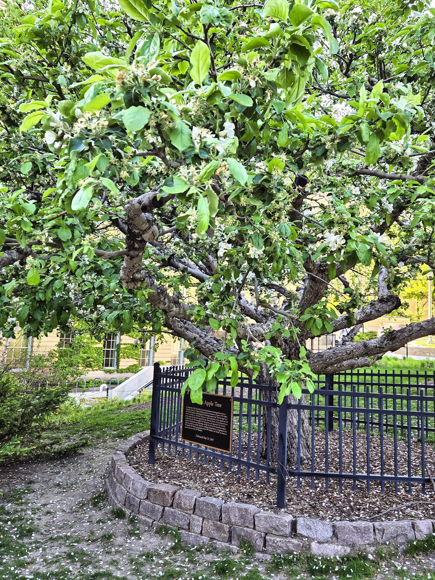
One plant and plaque stopped me in my tracks: a picturesque apple tree surrounded by a fence. The tree sported white blossoms and looked older than its 23 Years. Reading the sign, I learned that the tree, planted in 2001, is a direct descendant of the original tree that bore the fruit which inspired Sir Isaac Newton’s Theory of Gravitational Forces.
Huh. I always assumed that the whole apple falling on Newton’s head thing was a myth. But now here was living proof that the tree from which said apple fell not only could be identified, but its offspring was living in Madison!
The plaque said the original “Newton Apple Tree” grows on the grounds of the National Institute of Standards and Technology. But that institute is in the United States (in Maryland). I thought Newton made his discovery in England.
So, in writing this post, I did some digging. The institute tree the Madison tree is grafted from was a clone. Alas, the clone fell over and died about a year ago “due to unknown reasons” according to Wikipedia.
Tulips and a crabapple tree were in bloom in UW-Madison’s Botany Garden. The person in the image is taking a picture of the tulips from below.
The actual original Newton tree grew in the 1600s on the grounds of the English manor where Newton was raised. The Woolsthrope Manor tree has died, but its descendants and clones live on at the manor and many other places around the world.
The story of the apple inspiring Newton’s theory gained public visibility when Newton’s niece related it to Voltaire, who included it in an essay. The apple, however, did not fall on Newton’s head. That is a silly myth.
The Madison tree was planted in honor of F. James Sensenbrenner, chair of the U.S. House of Representatives Committee on Science (1995-2000). Sensenbrenner was a Republican congressman from Wisconsin and a graduate of UW-Madison. From the plaque text, it sounds like Sensenbrenner presented the tree to the university himself in hopes that “the fruit of this descendant inspires others to partake in scientific discovery.” This strikes me as rather self-aggrandizing, but it was a nice gesture, no doubt accompanied by some additional funds.
As if having a copy of the Newton tree isn’t enough, the UW-Madison Botany Garden was the first in the world to be based on the new Angiosperm Phylogeny Group system of molecular classification of plants. I don’t really know what that means but if you visit the garden’s webpage, there’s a chart about that.
As I continued my walk through the garden, I envied the Madisonians their warm breezes and blooms. In northern Minnesota, our daffodils are just beginning to show. It will take us about three weeks to catch up to the plants in Madison. Sigh. But this way, lucky me experiences two blooming seasons and that’s just fine.
I exited the garden, glad for my little educational and botanical detour and that I’d have something to share with you. And now you know more than you probably ever wanted about Newton’s apple tree!
Cullen Skink soup, homemade bread and tea served at the Laird’s Kitchenin Delgatie Castle (2016).
I know what you’re thinking – that is an unappetizing name for a soup! But there’s a reason behind it.
Back in 2016, when my friend Sharon and I traveled to Scotland, we became acquainted with Scotland’s version of chowder, thanks to some friendly people in a café in Gardenstown. The soup is called Cullen Skink and they said the best place to find it was Delgatie Castle, which was not too far away.
We took them up on the advice and ate lunch at the café in the basement and then toured the pinkish castle. We tried the soup, which is made with smoked haddock, potatoes, and onions – thus, a very white dish. It was served with homemade white bread slathered with butter. More whiteness!
Delgatie Castle, Scotland, where I had my first Cullen Skink.
The soup was very creamy and good. I am a chowderholic, so I loved it. The café is also known for its scones, which were lovely. The soup was invented in the Scottish town of Cullen. It was created from deprivation and want. The skink part of the name is usually reserved for soups in Scotland with ingredients like a shank of beef or ham. Having none of these on hand, smoked fish was used instead, but the name of “skink” stuck to it.
Cullen Skink has been described by The Guardian newspaper as “smokier and more assertive than American chowder, heartier than classical French bisque.” I agree.
The Scottish are proud of their skink, holding an annual Cullen Skink World Championships competition. The most recent event was just a couple of weeks ago in a hotel in Aberlour.
Kellie Spooner, excited winner of the 2024 Cullen Skink World Championships. Image courtesy of NE Scotland BBC.
During our trip, Sharon found a recipe in a travel guide and took a photo of it. I recently came across the image and decided to follow up on my long-ago plans to make the soup at home. The only problem is that smoked haddock is impossible to find in my neck of the woods. So, true to the original nature of Cullen Skink, I had to make do with what was at hand, and that was a Lake Superior smoked whitefish.
To make the soup even more white, I substituted white pepper for black pepper. For the milk, I used Carnation brand evaporated milk because it was on sale. But I had forgotten I can’t have it due to my intolerance to corn and any ingredients derived from corn. Carnation contains dextrose, which is derived from corn.
I had migraines for two days as I ate the soup and its leftovers, until I figured out the culprit. So, if you have a corn intolerance, keep that in mind! The generic brand of evaporated milk at my store is free of dextrose, so I will use that next time.
If you want to introduce a bit of color into the soup, I suggest using B-sized (new) red potatoes and not peeling them. The parsley also adds color.
I forgot to soak the smoked fish overnight in the milk beforehand, but it still came out tasting great! If you love chowder but are looking for something different, this is the soup for you.
Here’s my version, which I have named Lake Superior Skink to honor the fish from Lake Superior that I used. If you use a local fish species, feel free to call this recipe your own geographic version of skink. For instance, a version containing catfish could be called Mississippi River Skink. Yet another appetizing name!
2 Tablespoons butter 1 onion, diced 2 pints evaporated milk (approx. 3 cans) or whole milk 1-1/2 lbs potatoes, peeled and diced 1 lb smoked Lake Superior whitefish or lake trout 2 teaspoons dried parsley sea salt and white pepper, to taste lite sour cream
Soak fish in milk overnight to infuse extra smoky flavor into the broth.
Melt butter in a pan, add the onion and cook gently for 7-8 minutes until it is soft but not browned. Pour in the milk and bring to a simmer. Poach the smoked fish for 3-4 minutes until it is cooked and will flake easily.
Carefully lift the fish out onto a plate and leave it to cool slightly. Add the diced potatoes and simmer for about 20 minutes until soft. Blend some of the potatoes with a stick blender to thicken the soup a little. If you have a regular blender, put about a quarter of the soup into it, blend, then return to the pan.
When the fish is cool enough to handle, break it into flakes, discarding the skin and bones. Return the fish to the pan and stir in the parsley and spices. When serving, add sour cream as desired.
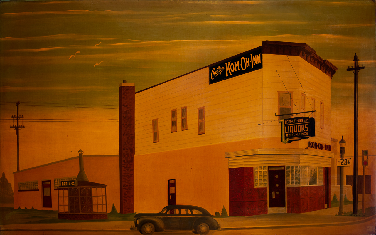
The Kom-on-Inn in West Duluth. Image courtesy of Jennifer Webb, University of Minnesota Duluth
I recently worked in a bar. Not as a bartender, though. I didn’t even drink! I was there to view art and explore how it relates to community and the restoration of the St. Louis River, which flows along the border of Minnesota and northwest Wisconsin. You can view my resulting story on Wisconsin Sea Grant’s “Unsalted” blog here.
In preparation for a trip to Ireland and Scotland that Russ and I are planning, I was rummaging around in a genealogy book that my mother and her sisters prepared about the side of my family that has U.K. roots. I was looking for Irish names. I came up empty. Thanks to family lore and 23 & Me, I know I have Irish blood but I’m not sure where it came from.
As I rummaged around in the book, I came across a pamphlet written in 1877 by Willard Parker (Detroit, MI) that I had noted before but never spent much time reading. It was about my Great (to the 4th power) Grandfather Caleb Parker. He was born in 1760 in Shrewsbury, MA, to Stephen Parker Jr. and Abigail Wright.
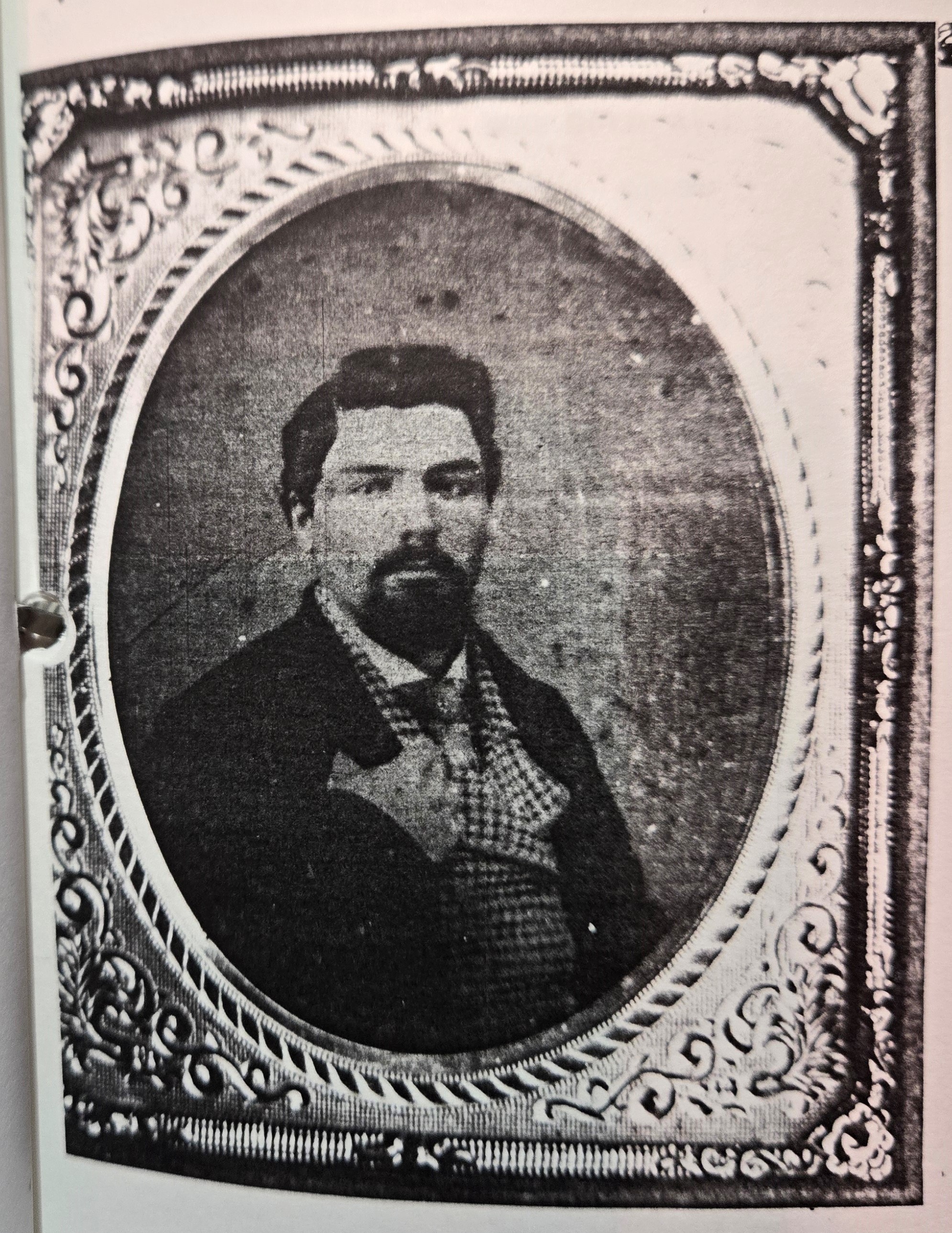
Caleb Parker
The surname of Parker originated in France. In essence, it means “park-keeper” and is an occupational name describing a gamekeeper. Could this be why I like “Lady Chatterley’s Lover” so much? (The book’s main character is a gamekeeper.) The name was introduced into England after the Norman (Viking/French) invasion in 1066.
Caleb’s original name was Nathaniel, but his parents changed that along the way to honor his brother Caleb who died in the French and Indian War in 1755 or 1756. The soldier was never heard from by the family. I suspect Nathaniel must have been very young when his name change happened. The French and Indian War ended in 1763 when Nathaniel was three, so maybe his parents changed his name during that time, once they gave up hope of Caleb the elder’s return.
Caleb/Nathaniel married a woman named Thankful Pratt of Shrewsbury in 1782 when he was 22 years old. He was a soldier in the late part of the Revolutionary War. While in the army fighting under George Washington, he acquired a taste for military life and in 1793 (after he had moved to Vermont), the governor appointed him captain of the Vermont Militia.
Militia fighters were also known as minute men because they had to be ready to drop everything they were doing at home with only a minute’s notice when needed for battle. They are immortalized in Longfellow’s poem, “Paul Revere’s Ride.”
About six years later, Caleb resigned his commission and moved to Stukley, an eastern township of Lower Canada, not far over the Vermont border. He died there in 1826. His wife, Thankful, lived 23 more years, dying in Stukley in 1849.
The couple had 11 children who met various fates. One was killed by a falling tree. One was a founder of Stukley township. The writer of the pamphlet said that Caleb’s “descendants have been mostly tillers of the soil. If there have been but few distinguished men among them, I may say, in all truthfulness, that honesty, industry, temperance and Christian character have been the prevailing characteristics of the son and daughters” of Caleb. “These qualities have been inherited from our emigrant ancestor [Thomas Parker], whose descendants in New England are not unworthy to rank honorably with those among whom they dwell.”
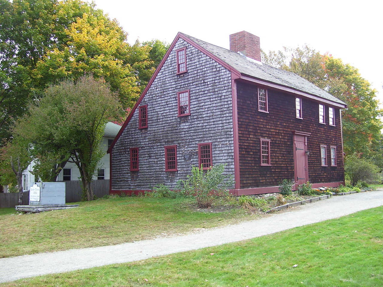
Parker Tavern image: By Swampyank at English Wikipedia, CC BY-SA 3.0
Thomas Parker, Caleb’s grandfather, came from England originally, sailing on the ship “Susan & Ellen” in 1635. I was surprised to discover that he has his own Wikipedia entry! Thomas was a Congregational Church deacon and had a large family with his wife, Amy Aylesworth. He founded Reading, MA. I also discovered that the oldest surviving building in Reading is named after the family. The Parker Tavern was owned and operated by Thomas’s great grandson Ephriam and it has been turned into a museum. I’m thinking a trip to Reading, MA, is in order someday!
If I were more talented with graphics, I would make a genealogical chart for you, but my skills do not lie in that direction. I did scribble one out with pen and paper for my reference, though, to try and keep everyone’s name straight.
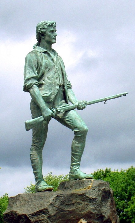
My line of the family is descended from Thomas’s son Nathaniel Parker. But Thomas had another son (I’m unclear whether his name was Hananiah or Thomas) who had some notable descendants. One is John Parker who was another minute man like Caleb. John led the Lexington, MA, militia in 1775. In fact, he was a model minute man. A sculptor used his likeness for the famous Lexington Minuteman statue that stands on the Lexington Battle Green.
The Minute Man statue on the Lexington Green. It’s based on militia captain John Parker.
John led the fight against the British in the battle of Lexington on the day the Revolutionary War began. The militia suffered lopsided losses to the British (8 militia killed, 10 wounded to only one British soldier wounded). One of Parker’s men, many years later, recalled Parker’s orders on the Lexington Green: “Stand your ground. Don’t fire unless fired upon, but if they mean to have a war, let it begin here.”
During the skirmish, John witnessed his cousin Jonas Parker killed during a British bayonet charge. Later that day he rallied his men to attack the British returning to Boston in an ambush known as “Parker’s Revenge.”
John is featured as a character in the book and movie called “April Morning,” which is about the beginning of the Revolutionary War. The book is mandatory reading in many a U.S. classroom.
Sounds like I will also need to visit Lexington in addition to Reading some day! I can’t believe that a relative of mine was involved in the very beginning of the Revolutionary War. If I had known that earlier, I would have paid a lot more attention to my American History class in school.
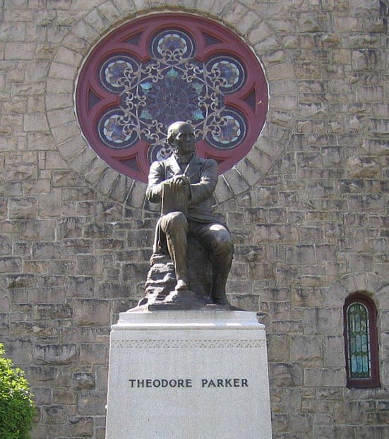
The other notable descendant is Theodore Parker. John was his grandfather. Theodore was a noted Unitarian minister and abolitionist. Just out of Harvard Divinity School, Theodore preached at a church in the Boston neighborhood of West Roxbury. That church still stands today as the Theodore Parker Unitarian Church with a statue of Theodore on its grounds. But eventually, he left after being kicked out of the Boston Unitarian brotherhood for his “radical” views on abolishing slavery and other religious matters. He also believed outrageous things such as women should be allowed to vote, and to become doctors, lawyers, and (gasp!) even ministers.
Reverend Theodore Parker
Theodore is credited for famous quotes later shortened and used by President Lincoln and Martin Luther King. The phrases are, “a government of the people, by the people and for the people” and “the arc of the moral universe is long but it bends toward justice.” The former was used by Abraham Lincoln in the Gettysburg Address and the latter by Martin Luther King.
By coincidence, I’m a Unitarian! (Or perhaps it’s not a coincidence?)
Those Parkers were quite a bunch. It’s not every day that a person discovers their ancestors have their own Wikipedia pages, movies, statues, and a tavern and a church named for them! Plus, I learned that they founded two towns. I don’t think my mother and her sisters knew any of this because they never mentioned it.
Although my search for Irish ancestors was unsuccessful, I learned more than I ever dreamed about my family and their role in shaping early America.
Theodore Parker’s statue in front of the Theodore Parker Church, a Unitarian parish in West Roxbury, Massachusetts. Photo by By Biruitorul (talk) – Biruitorul (talk), Public Domain