The Mesabi Bike Trail from Mt. Iron to Kinney, MN

The beginning of the Mesabi Trail in Mountain Iron.

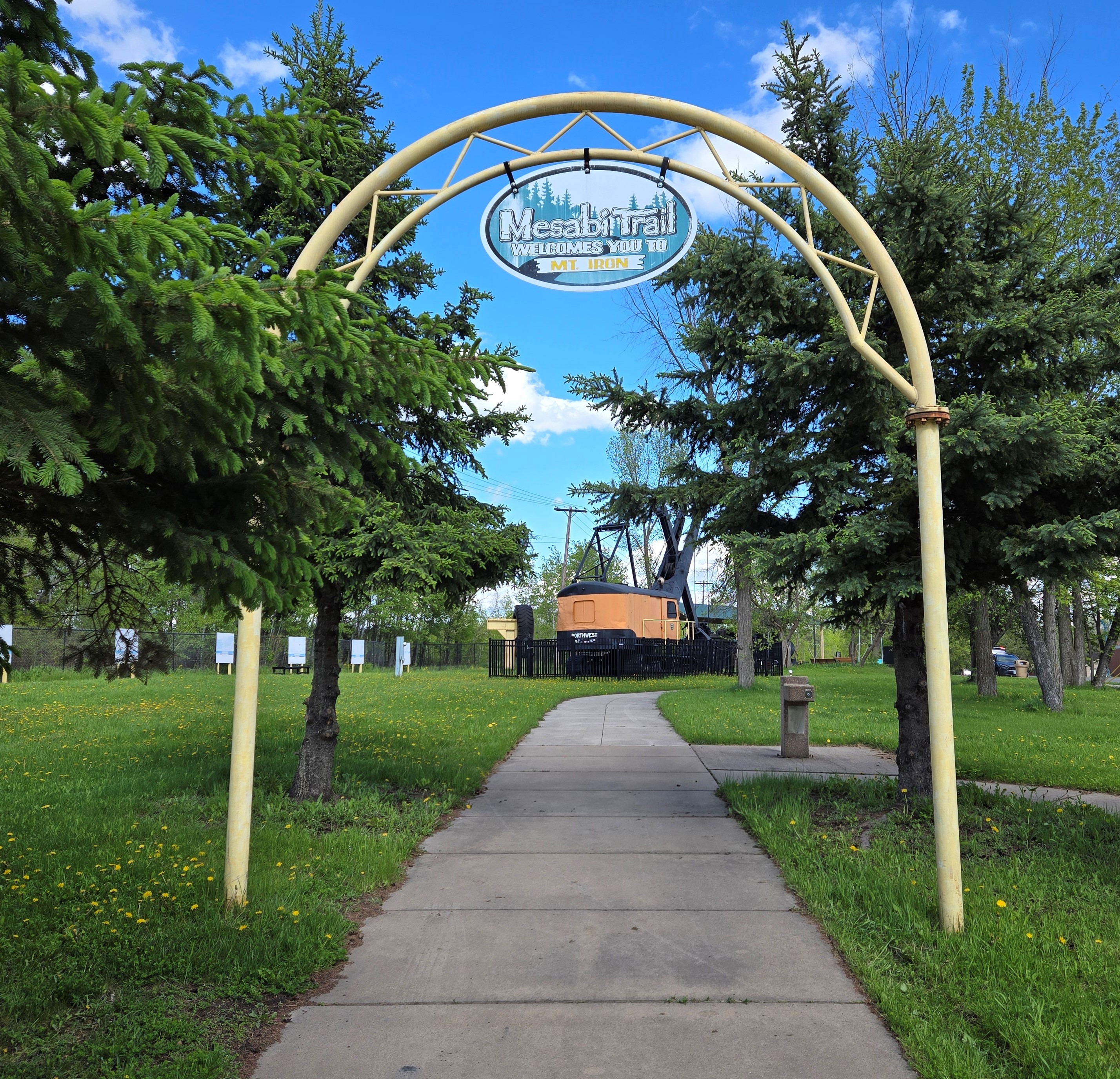
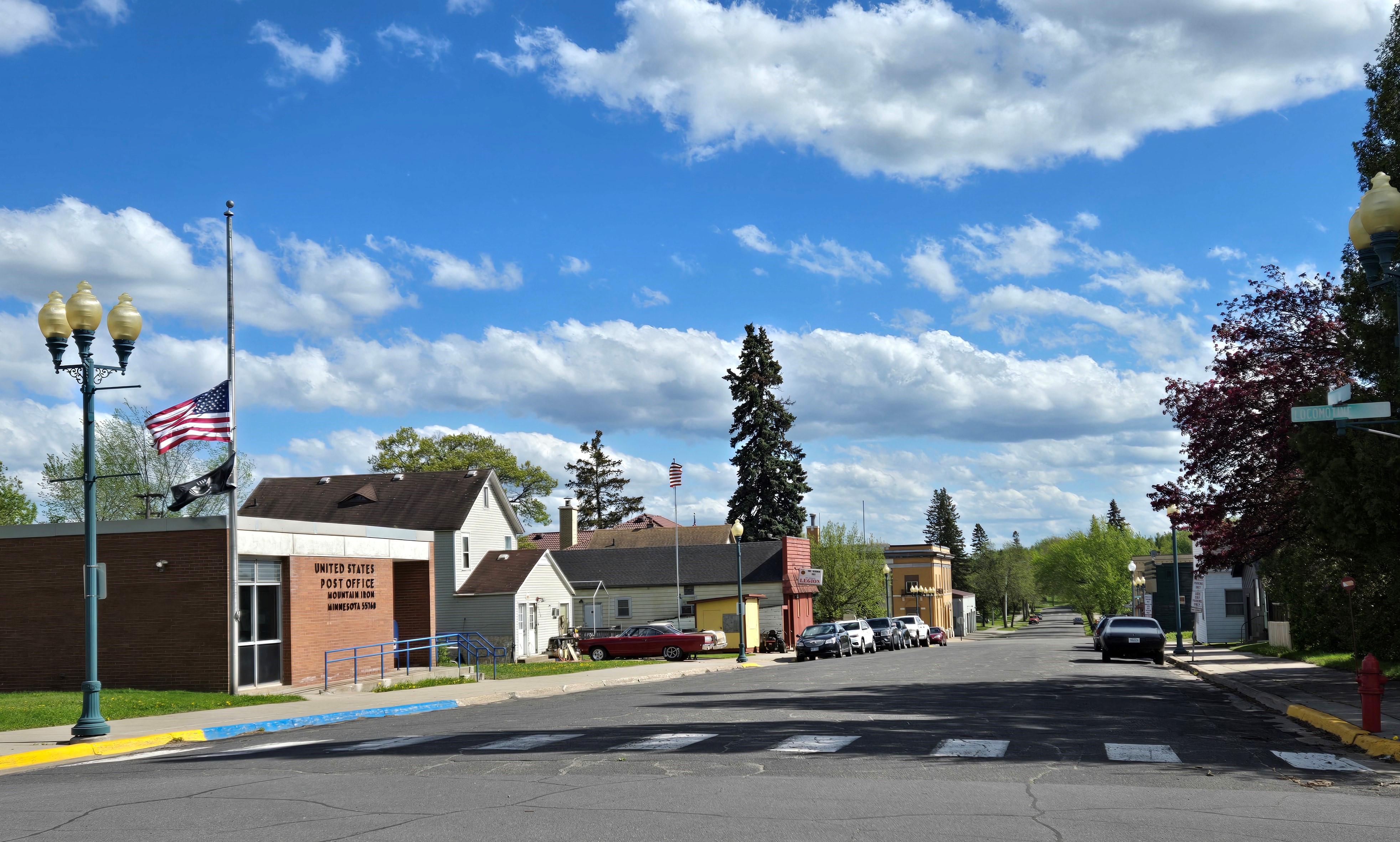
In our continuing quest to bike different sections of the Mesabi Trail in northern Minnesota, Russ and I meandered over to the small mining town of Mountain Iron last weekend. We planned to pedal a 6.5-mile stretch between there and the neighboring town of Kinney. (Round-trip, the distance is a little over 13 miles.)

Mountain Iron is known as “The Taconite Capitol of the World.” It’s the site where iron ore was first discovered on Minnesota’s Iron Range. The mine is no longer in operation, but during the 30 years it was open, 52 million tons of iron ore were shipped to various steel mills in places like Michigan and Illinois.

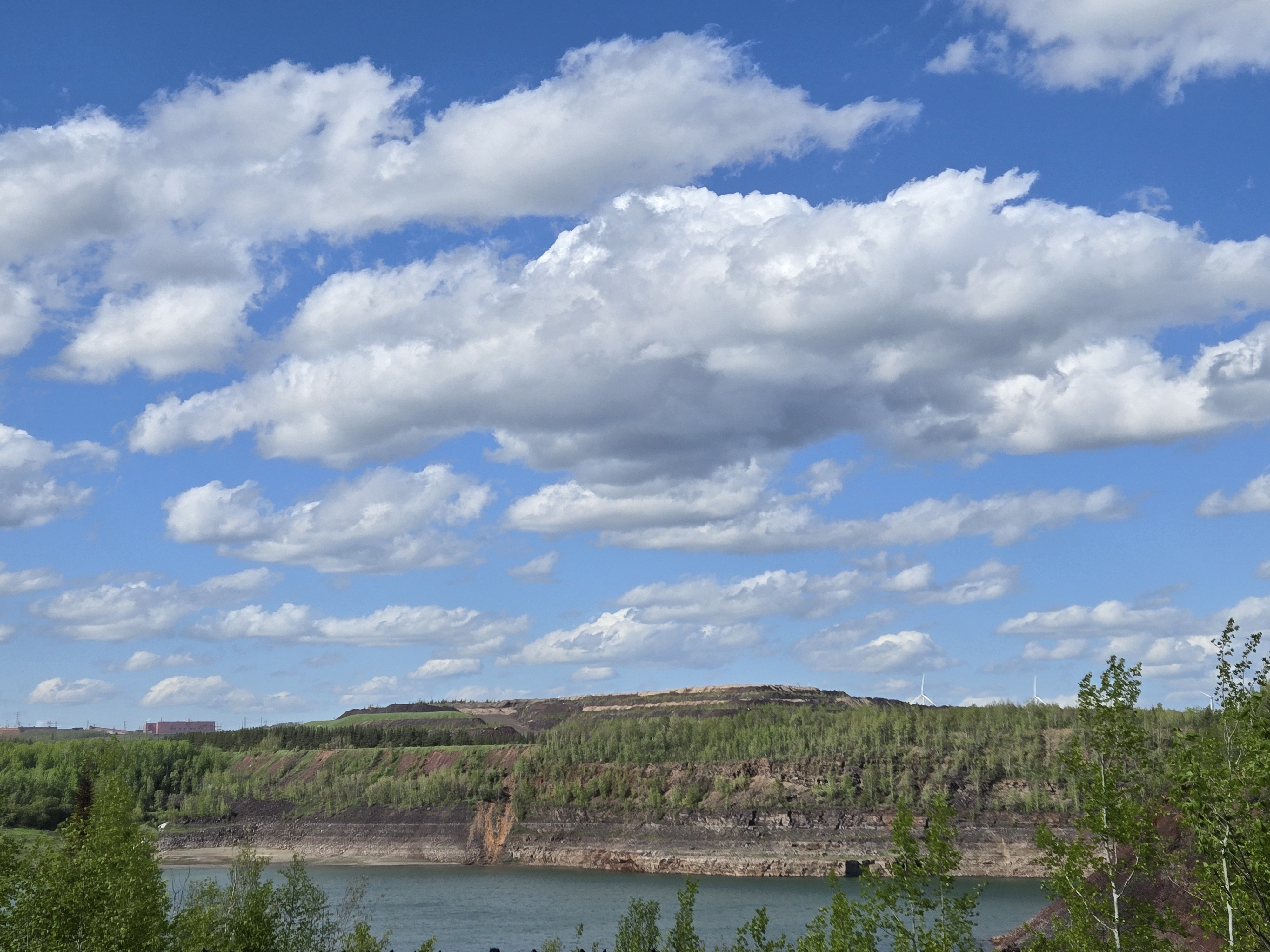
The landscape and town bear the scars of this industry. A huge mine pit filled with turquoise water is visible from the small city park where the trail begins. As we biked toward Kinney, we passed ghostly remnants of homes and businesses that had been moved to make room for mining operations. Cement house pads and neglected lilacs provided testament to the abandoned homesteads.

The open pit mine in Mountain Iron. You can almost make out the wind turbines on the hill to the right.

These days, instead of iron ore, Mountain Iron is known for wind energy. Several turbines spin on far hills. They are part of the Taconite Ridge Wind Energy Center – the first commercial wind center in northeastern Minnesota. An interpretive sign in the park says, “In ideal wind conditions, 10 turbines can collectively capture the wind and convert it into 25 megawatts of electricity – enough to power 8,000 homes on an annual basis.”

A typical section of the Mesabi Trail.

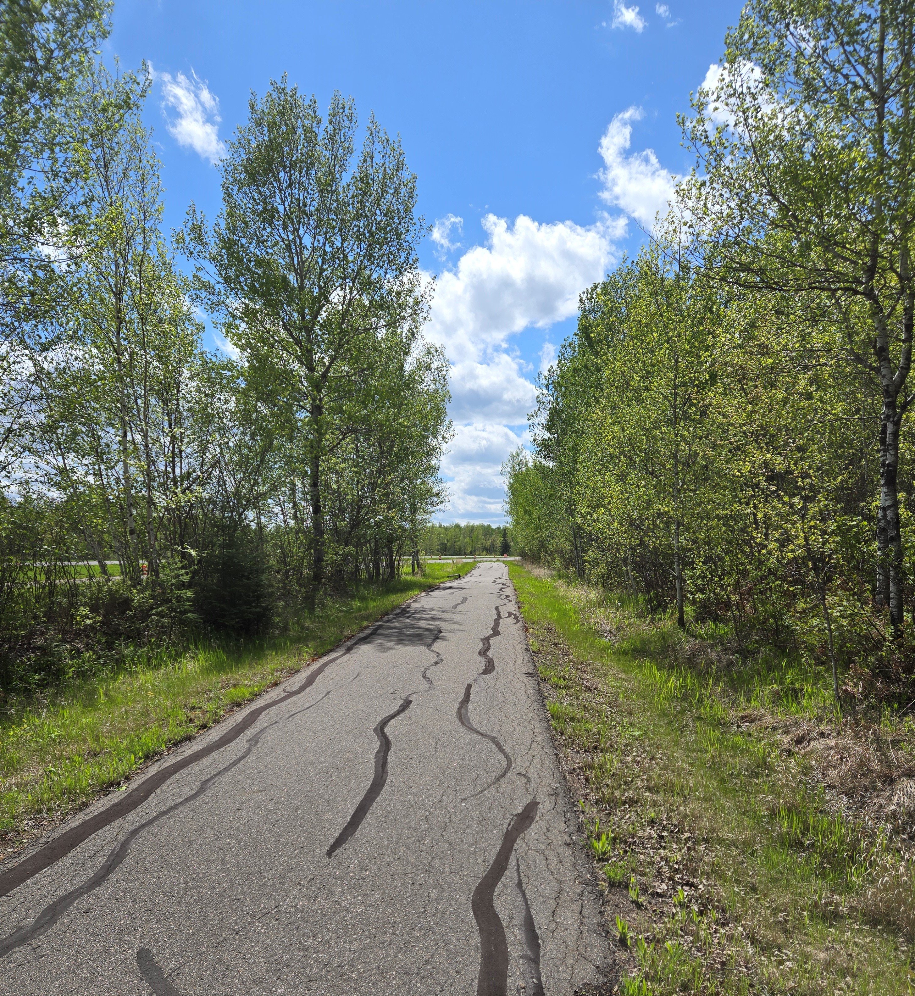
Compared to other sections of the trail we’ve biked, this was more civilized. Once we passed the abandoned neighborhood, a few occupied homes lay along the trail. Huge grassy piles of mining tailings lined the horizon. Although a sign along the way says that tailings are not a health hazard, I don’t believe it! We saw a lined basin where it seemed like water was being pumped from the base of the piles. I couldn’t find any info about that online, but I am hoping it’s so the water can be collected and treated before being released into the environment. For much of the way, the trail parallels a highway, although it’s often hidden from view by trees.

A couple of hills dot this section of trail, but nothing too onerous. When you first near the highway, there is a hill with a curve at the bottom. Bikers coming the other way also have a downhill before the curve, so beware of that. Two downhills lead over small bridges with culverts underneath them. The culverts each form a bump. I almost caught air on one of them!

We saw one bicycling family and a few other small groups. When we reached the turn off to Kinney, we did not feel the need to explore. But now, after reading more about the town, I wish we would have. Kinney once voted to secede from the United States and become a foreign country. This bold yet tongue-in-cheek action was taken to draw attention to the small city’s dire water system situation.

According to an account on the Mesabi Trail website (linked above via “Kinney”), the system was “failing so badly that the fire department had to watch buildings burn to the ground due to lack of water pressure. That year the term ‘The Kinney Brown Shirts’ was coined because all clothing washed with detergent that included bleach turned brown because of mineral deposits in the water.

“Replacing the water system far exceeded the budget of the small town, so the city exhaustively searched locally and nationally for assistance. The resulting volume of paperwork led to the city’s motto of ‘File in Triplicate.’ The city attorney commented that it would be easier to get money if the city seceded, waged war with the union, quickly lost, and then asked for foreign aid. The joke took root, and the council voted unanimously to secede on July 13, 1977, and a certified letter was sent to U.S. Secretary of State Cyrus Vance.”

A sign with the new name of the town of Kinney after it seceded from the USA and declared itself a foreign republic. Image courtesy of the Mesabi Trail website.

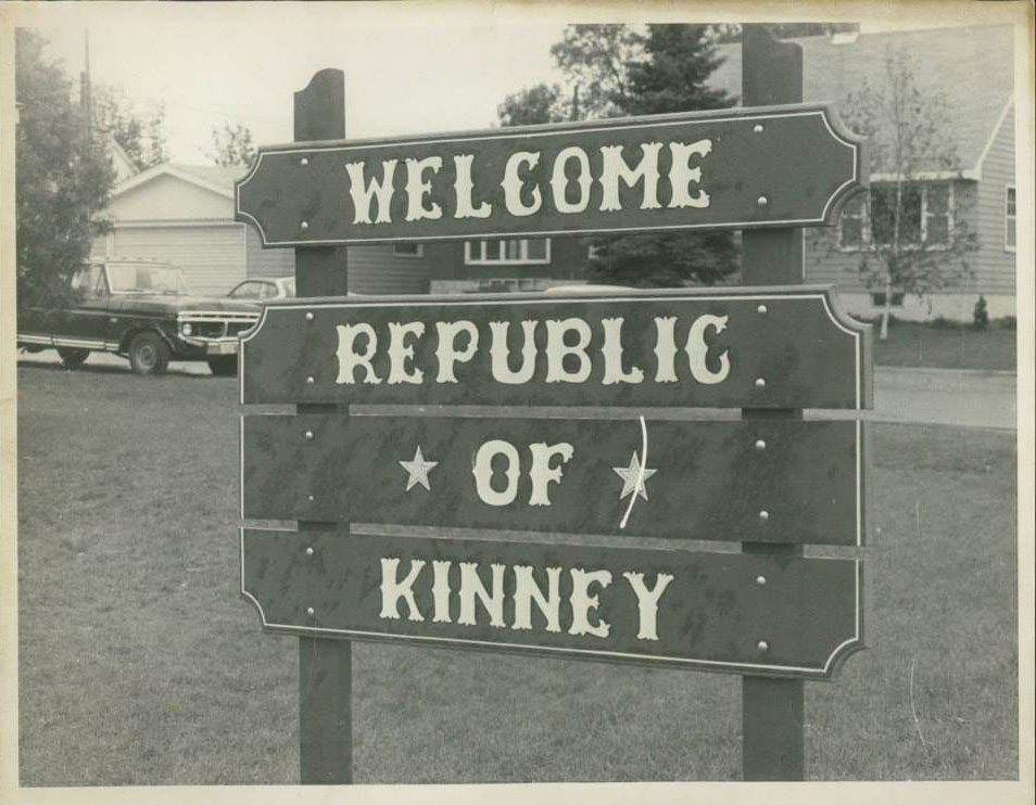
The secession gained international publicity and from that, the city eventually received grants to replace their water system.

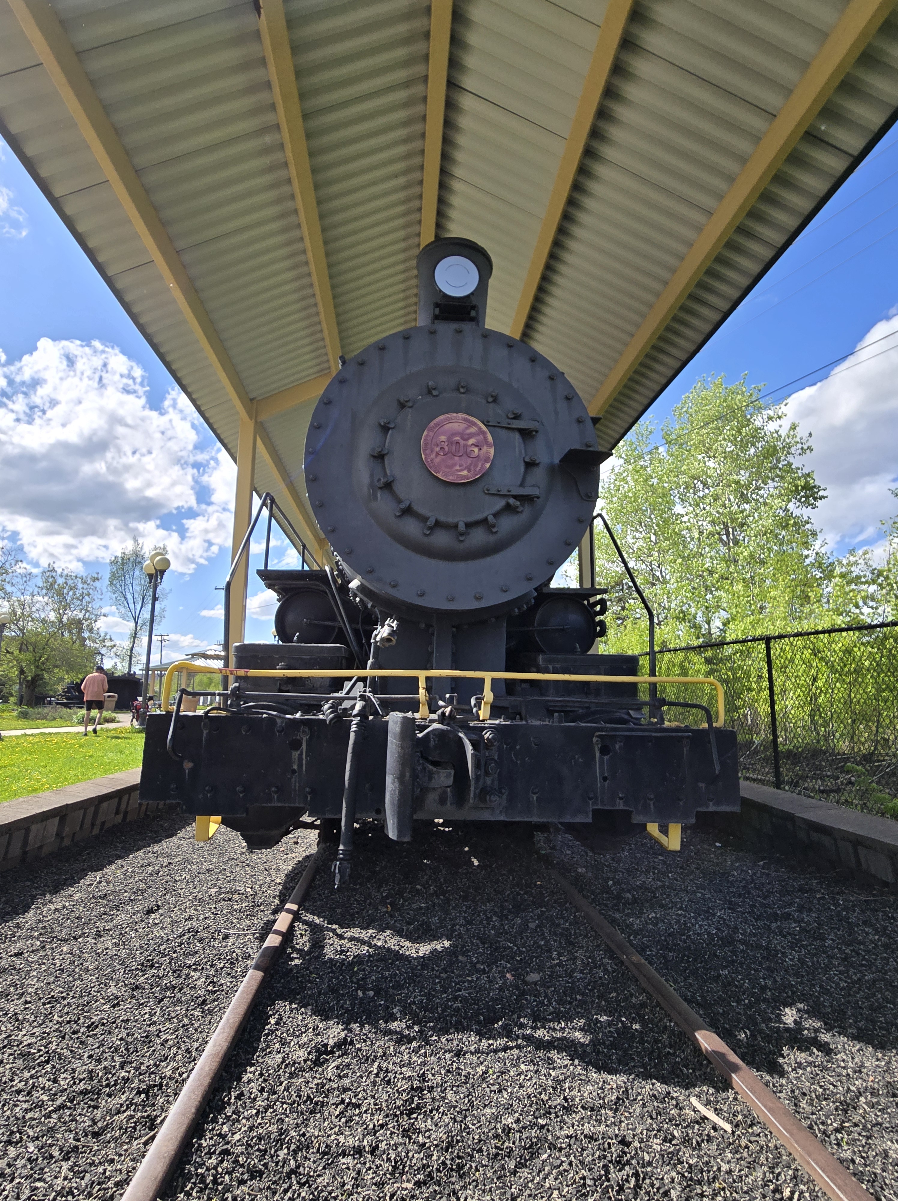
Our way back to Mountain Iron seemed easier than the ride out. I’m not sure if that was from the tailwind or the topography, but biking back was a breeze. Ride over, we spent time exploring the various pieces of mining equipment in the park. This included an old locomotive, which, no doubt, used to haul taconite to ships waiting for it on Lake Superior’s shore. Another group of bikers that we passed on the trail arrived and we chatted a bit. They were from St. Paul and were biking the entire trail, staying in hotels overnight.

Downtown Mountain Iron.

That’s it for our experience with this section of the Mesabi Trail. Maybe next time, we’ll start from Kinney to experience this plucky little burg.

The locomotive engine in the Mountain Iron city park where the bike trail begins.

Update: 8/31/25

Well, it took a while, but we did start cycling from Kinney. This hardscrabble town is composed mostly of trailer homes. Not that there’s anything wrong with trailer homes. I’m just not used to seeing so many of them near the center of town.

We biked from Kinney to Buhl, which is only 4K. From there we rode toward Chisholm, a section we’ve ridden in the past, but I don’t think I blogged about it. The most scenic spot was the Stubler Mine Pit Beach, which looked like a good spot for swimming. A bunch of folks were doing just that during our Labor Day Weekend ride.

The beginning of the trail was wooded, but then much of it follows an abandoned roadway. The most scenic part of the section past Buhl was the City of Chisholm sewage plant. Thus, this addendum and not an entire blog post.

Two Island River and Taconite Harbor: Off the Beaten Path

Two Island River waterfall

We’ve been driving up and down Highway 61 on Lake Superior’s North Shore more than usual lately to deliver and retrieve my photos that were on display in Grand Marais. On one trip, I noticed a river that flowed underneath the highway. No sign sported the river’s name. Looking landward as we whizzed past, I spotted a double culvert bridge about a hundred yards away that the river flowed through. Was that a waterfall behind one of the culverts? The scene was intriguing and not one I’d ever seen photographed by established North Shore photographers. I made note of the location and vowed to stop on our next trip.

That “next trip” was last weekend. On our way back to Duluth from Grand Marais, we stopped near the mystery river, which is near Taconite Harbor. The harbor’s a place where mining companies used to load taconite (iron-ore pellets mined and made on Minnesota’s Iron Range) from rail cars into ships bound for steel-making plants in Michigan and Illinois.

We parked our car in a driveway entrance that was blocked by a gate overgrown by saplings. Although the driveway had a fire number on it, that gate obviously hadn’t been opened in years, so we weren’t too worried about blocking access.

We walked across the highway and, as cars rushed past, took a short jaunt to the river. We hopped the guardrail in a likely looking spot and soon found a faint game trail. The trail also could have been made by anglers. We found out later that part of the river is considered an “Aquatic Management Area” allowing angler access by the Minnesota Department of Natural Resources.

Two Island River, see the culverts upstream?

It’s spring and we’d had a heavy rain recently, so the shallow river splashed with gusto over reddish-gray rocks. I clambered along the banks, camera in hand, taking photos at spots that offered a good vantage. But I was impatient to get to my goal: the double culvert up the hill, and that waterfall behind it.

Russ went ahead while I took photos. When I caught up to him at the railroad bridge with the culverts, he’d had time to look up the name of the river on his phone. We were looking at Two Island River, a 15-mile waterway. There’s not much info out there about it, but Wikipedia says the river is named for two lake islands near its mouth.

As you can probably tell, there was a waterfall behind the culverts. A very nice one, too. The steep angle of the sun and rising mist from the falls made for some blurry spots in my photos, but I managed to get a few images without amorphous blobs floating around in them.

Two Island River Waterfall (in color)

Waterfall appreciation over, we investigated the railway bridge. Like the driveway gate, the railroad was overgrown with saplings and obviously hadn’t been used in years. Research I did while writing this post uncovered the facts that the railway was named the Cliffs Erie Railroad. The last train operated in 2001, but after that, cleanup trains, which collected leftover chips and pellets from the mines, operated until 2008.

A bustling little town was situated near the Two Island River, probably accessed through that overgrown driveway where we parked. Taconite Harbor, Minnesota, was a mining town built by the Erie Mining Company. In 1957, twenty-two prefabbed homes were trucked into a several block area near the lake. The little community even had a fire hall, community center, playground, and baseball/tennis courts.

It seemed like a 1950s ideal community. Seventy-five children grew up there and probably played along the river’s banks. In the 1970s, families were driven away by noise pollution and health concerns about the taconite dust that blew off the rail cars and from local stockpiles.

The steel industry lull added another blow in the 1980s and by 1988, the last resident had left the little Taconite Harbor town. In 1990, the remaining homes and buildings were packed up and transported away by trucks. Driving past the site, I recall seeing only empty asphalt streets, home foundations and streetlights. Nature has reclaimed much of the area, but town remnants remain. It’s truly a North Shore ghost town.

Russ and I didn’t have time to investigate the town site ourselves, but there are many good images of it on the internet. “Forgotten Minnesota” has some good ones.

The Cliffs Erie Railroad tracks that cross the Two Island River bridge.

The history of this area also includes an event that I narrowly escaped. It’s an involved tale so I’ll start from the beginning. In 1957 when the little town of Taconite Harbor was being formed, the mining company also began dumping ash from its nearby coal-fired power plant near the river and the town. I’m not sure it was illegal at the time, but it probably was as time went on. The dumping continued until 1982 and the pile covered 27 acres.

On the morning of July 28, 1993, I drove up the highway in a pale green government car through a heavy rain on my way up to Grand Marais for my job with the Forest Service. Later that day, thanks to the rain and the fact that the mining company had been dumping excess water from a coal stockpile onto the ash heap, the pile became saturated and it liquified in a rare phenomenon called “static liquefaction.”

The heap collapsed and flowed downhill, covering the highway and contaminating the river and Lake Superior. It knocked out an electric substation and buried someone in their car who was traveling on the highway. I can’t find any news reports about the incident now, but as I recall, the person was rescued. I believe another car was partially buried.

All I could think of at the time is that could have been me! Luckily, it wasn’t. And luckily, I already had been planning to stay overnight in Grand Marais because the highway was unpassable and closed until the ash was cleared later the next day when I traveled home.

Russ also recalls hearing about a truck that hit the top of one of the railroad bridges that span the highway at that site. As a result, the bridge spans that cross the highway have been removed, leaving just the tracks and growing saplings on either side.

In short, this is a picturesque area that has had a lot happen to it! Its history of abuse and neglect is probably why the site is not sought-after by more photographers or tourists. That’s too bad. I suppose the mining company still owns the area and they obviously just want to forget about it. The river and the old town site could use some love. The nearby harbor has had some public funds put into it. It’d be nice to see the same for the Two Island River.

A Lake Superior Apocalypse Novel Review

Leif Enger and musician at Enger’s launch for “I Cheerfully Refuse,” a novel set on Lake Superior.

Duluth author Leif Enger’s latest novel, “I Cheerfully Refuse,” is set in the near future in small towns along Lake Superior and on the wide water itself. The apocalypse that’s occurred isn’t some cataclysmic event, rather the novel investigates what could happen if current conditions exaggerate. Citizens are increasingly desperate and illiterate, a billionaire ruling class referred to as “astronauts” (think Elon Musk and Jeff Bezos) employ indentured servants and conduct “compliance” experiments on people in medical ships that roam the seas. Lake Superior is subject to rogue storms and increasing temperatures. The warming waters finally give up the bodies that have lain preserved in icy slumber in its depths. School children have so many behavior problems from toxic chemicals they’d been exposed to in utero, they’re rated on a Feral Comportment Continuum.

Rainy, the narrator, is a bereaved bear of a man and a musician from the small mythical town of Icebridge on Minnesota’s North Shore. (If you read Enger’s previous novel, “Virgil Wander,” Icebridge is right next to Greenstone, the mythical town where that book is set.)

Image courtesy of Amazon

Through a series of unfortunate events, Rainy ends up fleeing Icebridge on a sailboat named “Flower.” Most of the novel follows his Gulliver-like travels to the Slate Islands and Michigan’s Upper Peninsula where he encounters fog, hunger, storms, and lawless townspeople. But there’s also poetic beauty in gulls that settle on his sailboat when he plays his bass, magisterial island rocks, and unexpected kindnesses from strangers. I don’t want to give away too much more of the plot.

Things I loved: The novel’s focus on the importance of music, books and literacy. The sailboat setting, and Enger obviously knows his nautical terms, having had a boat himself in Bayfield, Wisconsin. I also appreciated the hopefulness amidst the horror.

Things I didn’t like so much: The book’s ending. Although it’s beautiful and literary, I expected more after the epic events that led up to it. Once Rainy reaches his ultimate destination, readers are only given a few vague lines about Rainy feeling a slight warm weight against his back, “a pressure like a palm between my shoulder blades.” A few dream-like images round it out and that’s it. But I still think I’ll give it a 5 on Goodreads because the writing is so gorgeous, and we Duluthians need to support each other. The world out there is already cruel enough.

I attended Enger’s Duluth launch last April and noted a contrast to his “Virgil Wander” launch six years earlier. That event was held at a local independent bookstore shortly after Enger had moved here. About 45 people attended and ate brownies and bars made by Enger’s wife, Robin.

His latest launch was held at a local brewery where people’s food order buzzers interrupted Enger’s presentation as their pizzas arrived. I’d say the audience tripled, which is a testament to the connections Enger has developed in the community during his time here. True to the musical emphasis in “I Cheerfully Refuse,” a guitarist accompanied Enger, playing through breaks in his reading.

Enger said he wasn’t sure if he could call himself an actual Duluthian yet or not. As he lies in bed at night, he still thrills at the sound of the lift bridge and ore boats in the canal communicating with each other with their horns. He thinks if he were a real Duluthian, that would all be passé.

I would answer: the trick is holding onto that wonder even after hearing the horns a thousand times. Then Enger will be a real Duluthian.

Northern Nights and Lights

Thanks to a gargantuan sunspot group 15 times the size of Earth, we on Earth in northern climes were treated to a spectacular aurora borealis display last night.

The evening began with a thunder shower, which led to a picturesque sunset, which was capped off by the northern lights display.

I ran around with my camera, documenting everything at our cabin in northern Minnesota. I had tried before to photograph the sky at night with little luck. But this time, it worked! My camera captured even more colors than were visible to the “naked” eye.

As I wandered on gravel roads in the middle of nowhere with eyes raised to the eternal mystery of the dancing sky, our resident loons began to call. Spring peepers croaked and a distant train whistle blew. We are so fortunate to live in these times, in this place.

Artist’s Point, Grand Marais MN

When last we met, Russ and I were in Grand Marais along the shores of Lake Superior for an afternoon photo reception at their local health facility. We decided to stay overnight after the reception and take a little photo expedition the next morning to a scenic spot on the harbor.

As we ate supper at the Gunflint Tavern, I came up with the bright idea to do a reconnaissance mission to the spot to prepare for the next day’s shot. I hadn’t been to Artist’s Point in several years and wanted a refresher. The sun was still up so we’d be able to see okay to walk along the break walls and rocky coast.

I must admit that I had a glass of wine with supper and then for dessert, a brandy old fashioned cocktail. Although the food at the tavern was lovely, that cocktail was truly memorable! A brandy old fashioned is made with muddled (smashed) maraschino cherries and orange slices. (For a photo, see this post.)

I don’t know what kind of cherries the tavern used, but they took the drink to a whole new level! They were dark maroon and tasted divine. I know they weren’t Amaro-soaked cherries because I’ve had those before. I wish I had asked our waitress what they were, but I didn’t.

Thus fortified, and wearing high-heeled boots, I ventured with Russ to the harbor. I didn’t even have my Nikon along (that was back at our inn), only my cell phone.

I clambered up on the break wall, but Russ refused. He’d had a drink with dinner, too, and didn’t trust his balance enough to join me. I, however, found that my dessert made me not really care that I was up on a rocky wall in high heels. Plus, the views! I immediately became inspired and started snapping away on my phone, wandering this way and that for the best views.

What was intended as a simple reconnaissance turned into a photo shoot in its own right. Here’s a gallery of my results.

I clambered off with wall none the worse for wear and we headed to our inn for a rousing card game. We slumbered until Civil Dawn – that time just before the sun rises. In our case, that was 5:30 a.m., much earlier than we usually wake.

We quickly dressed in gear appropriate for temperatures in the mid-40s. I gathered my tripod and camera and we drove down the hill a short way to Artist’s Point. The area is named for its picturesque views. Painters can often be found there.

The sky over Lake Superior began turning a light orange as the sun prepared to make its appearance. Songbirds were singing, mallards quacking. Shorebirds flitted from rock to rock in front of me on the beach. The air was calm.

The sun wasn’t rising close to the island where I hoped it would be, so I set up my tripod on the beach and started taking photos. As the sunrise progressed, I found some large rocks and old wooden pilings that made for an interesting foreground. I crouched for the best angle.

I stepped away from my camera a few times to enjoy the sunrise in its own right, without a viewfinder in front of it.

Then I made my way out to the point and the break wall. Russ stayed back again. By this time, the sun climbed higher, but it was too bright for a good photo against the island. Instead, I focused my efforts in the opposite direction — on the lighthouse in the harbor, which was lit by the reflection of the rising sun. As I shot, a gray fishing boat left for the deeps of the lake with a raucous chorus of gulls following in hopes of sharing the bounty to come.

As I was finishing, I noticed a man off to the side on the harbor shore. Was he a photographer, too? Was he seeing something I wasn’t? (Every photographer’s nightmare!)

Then I noticed he wasn’t holding a camera, but a fishing rod. Just an angler out catching breakfast before work.

My cold fingers told me it was time to stop taking photos, so I clambered off the wall and met up with Russ. We returned to our cozy inn, peaceful, inspired. Happy.

Catching a Wave

Catching a Wave. Image by Marie Zhuikov

You may recall that a few weeks ago I left my “photo babies” at a medical facility in Grand Marais, Minnesota, along the shores of Lake Superior. (For a refresher, read this post.)

Russ and I were able to visit my babies earlier this week at an afternoon reception for the photographers and artists whose works are featured on the walls of the facility. I was excited to visit my images and see where they were hung. They seemed well cared for and happy in their new surroundings. My four large images were together on one wall and the other smaller ones lined a different wall farther down the hallway.

For a while, I stood near my images, a fly on the wall listening to peoples’ comments about my photos. Hearing their compliments and theories was fun. Meeting members of the medical facility board and the other artists was an added benefit.

This was my first reception, so I wasn’t sure what to expect. We struck up conversations with several photographers who proudly took us on hallway tours of their works. There were a couple ladies from Duluth who I hadn’t met before.

When I was in the reception room enjoying snacks and a PowerPoint show of the images, several reception-goers approached me, wanting an explanation of how I took one of my photos. We walked back to where the large images hung and stopped in front of “Catching a Wave.”

Before I told the three ladies how I got the shot of a wave splashing off a rock on Madeline Island in Lake Superior, I wanted to hear their theories. All of them thought I used a tripod and that I took multiple shots.

Surprise crossed their faces when I told them I just sat on a rock with my feet dangling over the water and hand-held my Nikon. I took the image when I was on the island for my first-ever photography class. This image was from a class outing in a park along the lakeshore where we roamed. I thought it would be fun to try and “catch a wave” with my camera.

As I sat on the rock, I pushed the shutter in the moments after a wave hit the rock and sprayed. I only took a couple of shots, not even bothering to look at what I had in the field because it was hard to see my playback viewer in the sunshine. Instead, I hiked down the trail to the next viewshed.

But when I returned to my room after our class outing, I knew something was different with the rock splash photos when I scrolled through them on my camera. “What the heck?” I recall saying to myself. My wonder turned to pleasure after I downloaded the images to my computer and took a closer look. I’d caught the wave perfectly in two of them!

The ladies at the show pointed out a couple things about the photo that I hadn’t noticed before, plus some patterns in my other photos that I had not seen. Then we walked down the hall to view their images and they described the trials and tribulations involved in taking their shots.

Once the reception was over, Russ and I headed out to a local restaurant for supper. We planned to stay overnight and wake at dawn the next morning so that I could have a photo outing at a scenic spot on the town’s harbor before we left for the two-hour drive home. We may have been there for the photo reception, but why not turn it into a photo expedition, too?

As it turns out, that was a capital idea! I’ll share those images in my next post, but here’s a sneak peek:

Artist’s Point Sunrise, Grand Marais, Minnesota. Image by Marie Zhuikov

To see a slide show of the other photos I took during my Madeline Island photography class, please visit this post. If you’re interested in purchasing “Catching a Wave,” it’s available on canvas (24” x 36”) for $150. Since I took the class and that image as part of my day job, profits will be donated to the Wisconsin Sea Grant Program, which provides research and education programs about lakes Superior and Michigan. To see my other work, please visit my photography webpage.

If I Were a Real Photographer . . .

In my workaday world where I drive around, sit at my desk, eat, and sometimes sleep, I often run across photo opportunities that I don’t have the time or energy to pursue. I’ll be driving down Duluth’s hillside and see the sun shining in an interesting pattern on Lake Superior, but I have a work meeting to get to, so don’t have time to stop. Or, I’ll be walking into the grocery store and there’s a spectacular sunset but I’m on mission, so bye-bye sunset. Or, darn, I don’t have my fancy camera with me, just my cell phone, so I won’t take the shot.

Often at these times, I’ll sadly joke with myself, saying, “If I were a real photographer, I’d find a way to take that photo.” I can’t count how many times I’ve thought that over the years. My hope is that once I retire, I’ll have more time to follow up on these photo opportunities, but that’s about a year off.

This morning at our cabin, one of those moments happened again. I’d been awake in bed since 5:30 a.m. It was now an hour later, and sleep was not returning. From bed, I could see the lake, its far shore lit golden by the rising sun, water as smooth as glass with winter’s ice only recently melted.

Lying there, I thought, “If I were a real photographer I’d get outside and take that photo.” But I was cozy and drowsy. Outside, it was probably only 40 degrees.

But the spectacular shoreline lighting was only going to last a little while. It would be a shame to miss this opportunity. All I needed to do was get out of bed . . .

Beside me, Russ slumbered peacefully. I didn’t want any movements I might make to wake him . . .

Then, I thought about what fun it would be to actually be a real photographer this morning. Sure, I only had my cell phone, but that was better than nothing.

I hopped out of bed, donned my light blue fuzzy bathrobe, grabbed my phone, and jumped into my big Sorrel boots. As I headed outside, I could see the light fading from one section of the far shore. It wouldn’t be long before the bare trees were a drab brown once again across the whole thing.

As I neared our small beach, a duck farther down the lake took off in startled flight. That might have had something to do with it seeing a blue monstrosity emerge on shore!

I raised my phone and fired off a few shots, walking along the shoreline to gain a better vantage. The sun lingered for a few more minutes, enough time to take a few good images. I especially liked one with some reeds in the foreground.

Phone lowered, I stood for a while, drinking in the view directly with my eyes. All was still and quiet.

I turned to walk back the few yards it would take to get to the cabin. After a couple steps, I was stopped by the sound of something crashing through underbrush in the neighbor’s yard. I recognized two dogs, Kamikaze spaniels, as I like to think of them, headed right toward me! One sported black spots, the other brownish-red.

I knew from previous encounters with their master on the road, the dogs running beside his ATV for exercise, that they were nice dogs with a lot of energy. Whenever they pass a driveway, they head down it, circle the yard with noses to the ground and meet their master back on the road.

Still, to ensure they were forewarned of my presence, I greeted them with, “Hi dogs, hi dogs!”

Unlike the duck, the dogs took no notice of me and sped right past. One rounded the far corner of the cabin and headed back to the road, while the other took a detour around our boathouse and then ran through the forest, rejoining its buddy.

In all, I was only outside this morning for a few minutes, but a lot happened. As I opened the cabin door, I felt a bit more like a real photographer.

My morning’s work.

In Which I get Paid to Work in a Bar

The Kom-on-Inn in West Duluth. Image courtesy of Jennifer Webb, University of Minnesota Duluth

I recently worked in a bar. Not as a bartender, though. I didn’t even drink! I was there to view art and explore how it relates to community and the restoration of the St. Louis River, which flows along the border of Minnesota and northwest Wisconsin. You can view my resulting story on Wisconsin Sea Grant’s “Unsalted” blog here.

“Meander North” Book Interview

“The Lift” host Baihly Warfield interviews me about my blog-based book.

I was interviewed on local TV about my blog memoir, “Meander North,” the other day. It was a live interview, so was rather nerve-wracking. I’m not complaining, though! I appreciate every bit of free publicity and the interview seemed to go well. I had another live interview for work a few weeks beforehand, so I had some practice. You can watch the hoopla here.

For more information about my book, please visit my website.

Missing my (Photo) Babies

About a week ago, we drove north along the shore of Lake Superior to Grand Marais, Minnesota. We carried a precious cargo: a dozen landscape images I took, printed out on canvas, metal and paper. They had been accepted for my first public exhibit at a local health facility in the town.

I was excited by this opportunity to share my hobby with an audience. Once we arrived, we were met by the organizer who helped us unload. He also showed us where the images would be hung. We left my works with him and headed home on our two-hour drive.

After a half-hour cruising past pine trees along the rugged landscape of Lake Superior, I began feeling like I’d left something important behind me in Grand Marais. The feeling nagged until I acknowledged it and searched my psyche for its source.

One of the babies I left in Grand Marais, MN. This is Oberg Lake in northern Minnesota.

It didn’t take long for me to realize the important things I left behind were my photos! The feeling was similar to when I dropped both of my children off at college. I turned to Russ and said, “My babies! We left my babies back there!”

He looked at me quizzically, but Russ is a quick study and soon smiled.

I did not expect that feeling. I didn’t realize I was so attached to the images, many of which have hung in my home for several months. It’s not that I don’t trust the exhibitor, it’s more I feel like I’ve left part of me in Grand Marais. Of course, the feeling isn’t as strong as what I have for my human babies, but it kept coming back over the course of the next few days. Russ got used to hearing me blurt sporadically, “My babies, I miss my babies!”

As with dropping my children off to college, I hope this is a one-time thing that will get better with time. But it’s made me wonder if other photographers experience this when they let their images out of their sight. I’d appreciate hearing any impressions you wish to share.