Not much has been going on lately in my mind or in my personal life, thus the paucity of posts. But I have been blogging for work. I attended a two-day wild rice symposium recently in northern Minnesota and learned all sorts of useful tips for harvesting this wild delicacy. Plus I learned more about efforts to restore it to lakes where it has disappeared. Read more here.
You may recall my recent “immersive experience” into ricing. I heard many similar tales of tipped-over harvesting canoes, so felt in good company.
Gobs of people attended the symposium — well over 200. It was good to see so much interest in the topic!
One of the small docks along the shore of Bear Head Lake.
Russ and I had only used our Scamp trailer once this summer (to Pictured Rocks National Lakeshore), so, we decided to get one more trip in before the snow began to fly. We chose Bear Head Lake State Park in northern Minnesota for several reasons: it was nearby, and we had passed the turnoff for it several times and wondered what it would be like to stay there. We were also intrigued because we’d heard that in 2010, it won the America’s Favorite Park contest. It must have something going for it!
We pulled into our site on a Friday evening. We chose a site on a loop that bordered the lakeshore. One thing that impressed us was that all campers have equal access to the shore. No sites are directly on the lake (they’re across the road from it), but there are several trails off the road that lead down to small docks that are perfect for fishing or lake-gazing.
The beach at Bear Head Lake State Park.
The air was warm for mid-October and the wind was calm. After our Spam and eggs supper, we took a walk on trails along the lake. The tamarack trees and aspens were still clothed in their splendid yellows. The trail ended at a beach surrounded by tall red pines. We’d find out later that these pines were spared during logging times because they were too small to be of interest. Good thing the place is a state park because they’d certainly be of interest to loggers now!
A Trail Center building nearby offered bathrooms and a warm place for hikers to gather before heading out on any one of the park’s 13 miles of paths. I discovered later that the impressive center was built thanks to the park’s standing in the 2010 contest, which was sponsored by Coca Cola. The park won $100,000, which they spent to build the center.
At the time, the park staff credited their win to Facebook and the power of social media because a popular bear frequented the park and people wanted to help draw attention to the bear’s home. The bear is no doubt long gone, but the Trail Center stands as a testament to the good will of social media strangers.
After our hike we enjoyed a fire (firewood is for sale at the park office). Our plans to hike the next day were disrupted by a steady drizzle. We opted to drive to Ely, Minnesota, instead. One of our stops was the Dorothy Molter Museum, which I described in my previous post. We also ended up getting a private tour of the Pioneer Mine Museum. Like the Dorothy Molter Museum, it was also open past Labor Day, contrary to its publicized operating season.
We didn’t intend to visit the Mine Museum. We began walking on a paved trail around Miner’s Lake but the steady drizzle and my failing health (I was catching the flu or something from Russ) made us turn around after a short jaunt.
As we neared our car in the parking lot of the Mine Museum, a man called to us from a building atop a nearby hill. He said the museum was open and he’d gladly give us a tour. Having nothing else better to do on a rainy day, we took him up on his offer.
The Pioneer Mine closed in 1967 and its payload was iron ore. The museum featured a plethora of artifacts and photos from its hey day. Our guide was Seraphine Rolando whose grandfather and other relatives had worked in the mine. Seraphine was a great storyteller and regaled us with tales of memorable rescues and descriptions of what it was like to work in the mine. Unlike the nearby Tower-Soudan Mine, the Pioneer Mine was wet, dirty, and much more hazardous.
Seraphine is a legend in his own right. I found this profile of him in the local Ely paper after I returned home. I easily remembered his name because one of my ancestors was named Seraphina, which must be the female version of his name.
Seraphine Rolando in the mine museum. Image courtesy of Trip Advisor
After our tour, we stopped at the Evergreen Restaurant in the Ely Grand Lodge for lunch. Interestingly, the lodge is built on a pile of mine tailings. The restaurant featured a beautiful view of Shagawa Lake and more golden trees.
Rain featured heavily on our next camping day, too. We ended up leaving for home a few hours early because I was now fully engulfed by the flu. But I recovered and am now ready for more meanderings.
Staying at Bear Head Lake State Park is like staying on a lake in the Boundary Waters Canoe Area Wilderness, but with more conveniences. Electric sites are available but not water hookups. A pump well is in the park and civilized toilet facilities are also available. They were closed during our visit, however, so we had to make do with an outhouse.
A final thing I wanted to mention was that one of our camping neighbors employed was using a leaf blower as they were packing up to leave. I suppose they were cleaning leaves off their outdoor carpet, or something. That was a new one on us – hearing a leaf blower at a campground. It’s bad enough hearing them at home, much less in a natural space. I sure hope this doesn’t become a trend!
Once upon a time, a woman lived alone in the northern Minnesota wilderness. Except, she wasn’t really alone. Birds and otters kept her company. Canoeists stopped by her island on Knife Lake near the Canadian Border. At one time, she even ran a resort there.
Image courtesy of the Dorothy Molter Museum.
But after the land was designated as an official roadless area and then a Wilderness with a capital W, making a living became more difficult for the woman, not to mention getting supplies. Rogue sea plane pilots tried to help her, but they were arrested. The only thing the woman could do was haul in the supplies she needed by canoe, portaging five times over the 33 miles to civilization.
In 1952, a writer with the Saturday Evening Post visited her and wrote a story about “The Loneliest Woman in America.” The article turned her into a national legend – a woman living alone among wolves and braving minus 50-degree winter temperatures. But the woman always contended the writer got it wrong, she was never lonely, even in winter.
One day, she was cleaning and found dozens and dozens of glass bottles left from when her resort served pop (as we call it in Minnesota). Rather than haul out the bottles and discard them, Dorothy Molter (as was her name) got the idea to make root beer for passing canoeists in the Boundary Waters Canoe Area Wilderness.
Dorothy Molter’s root beer cooler.
She hit the jackpot. If there’s one thing most wilderness campers appreciate, it’s a fizzy cold drink after days away from civilization. Dorothy made her drinks with root beer extract, sugar, yeast, and water from Knife Lake. They were cooled on ice cut from the lake in winter. Canoeists donated a dollar per bottle.
Dorothy made root beer for years. At the height of her business, she produced 12,000 bottles and still couldn’t keep up with demand. She was trained as a nurse and aided any canoeists who needed help by sewing up cuts and removing fishhooks from various body parts. She once saved the lives of a father and son who got hit by lightning in a sudden summer storm. Dorothy also nursed wild animals, including a crow and a mink.
A strong and plain-spoken woman, Dorothy didn’t swear or curse, but she didn’t mince words either. Her philosophy for surviving in the wilderness could be summed up in the sign she posted at her home on the Isle of Pines. “Kwitchurbeliakin,” it advised.
Dorothy continued living in the wilderness until she was in her late 70s. She kept in touch by radio, checking in with Forest Service staff daily. One winter day she didn’t check in. Then another day passed with no contact. A wilderness ranger made the trek and found her dead of a heart attack from hauling wood.
The Dorothy Molter Museum, Ely, MN
Although Dorothy’s time passed, her memory is preserved in a museum named after her in Ely, Minnesota. The fame and good will she garnered through her lifestyle prompted its formation.
Russ and I had heard of Dorothy over the years but never had a chance to meet her or visit her museum. We thought we were out of luck on a recent camping trip to Ely because a brochure we happened upon said the museum was closed after Labor Day.
With drizzly weather forecast, Russ and I ditched hiking plans and meandered into Ely to see what struck our fancy. We had driven though the whole town with no fancies struck, when we passed the sign for the Dorothy Molter Museum on the outskirts. The sign read “Open.” So, we turned in, hoping the sign wasn’t just the product of end-of-season-forgetfulness on somebody’s part.
The museum really was open! We spent a couple of hours touring Dorothy’s cabins, which volunteers had hauled out of the wilderness to house her artifacts. We enjoyed watching excerpts from a video about Dorothy’s life. We viewed her root beer-making equipment and perused the gift shop, where visitors can buy a bottle of Dorothy’s root beer. Despite the drizzle, we also got a bit of hiking in on the quarter-mile trail in the pine plantation surrounding the museum.
We left glad to see Dorothy’s memory preserved. As one of the museum signs says, “Although Dorothy has been gone from Knife Lake for over 30 years, we hope that you find inspiration to live your lives like she did, in harmony with the environment, with integrity, helping humankind, and making a contribution toward a better world.”
Well, it wasn’t the series itself that broke the internet in my neighborhood, rather it was a virtual presentation about it by Netflix that seemed to break it.
About a month ago, I was invited to an exclusive virtual screening of a new television series that’s being made out of the book, “All the Light We Cannot See,” by Anthony Doerr. I was invited because I rated the book on Goodreads.
However, right when the screening was supposed to begin, the internet went down at my house. Luckily, I was able to access the event via my cell phone. I sure was glad I signed up for that new unlimited data plan!
The event began with an introduction of one of the series’ main characters (Aria/Marie). Then the first installment of the four-part series was shown. It was filmed in Budapest and is set to air November 2 on Netflix. This was followed by an enthusiastic conversation between Doerr and the series director, Shawn Levy. I recorded it so I could make this blog post, complete with quotes and everything.
If you’ve been living under a literary rock, you might not know that “All the Light We Cannot See” won the Pulitzer Prize for fiction in 2015. I attribute this to Marie being one of the main characters’ names. Ha ha.
Marie-Laure is a blind girl who crosses paths with a Werner Pfennig, a German soldier, in occupied France during World War II. After her uncle disappears, Marie takes over his nightly clandestine radio broadcasts from the attic. Werner’s job is to track down resistance operations, including radio broadcasts. His life and Marie’s collide in this book, which illuminates the ways people try to be good to one another against all odds.
I gave the novel five stars on Goodreads, saying, “This book has *almost* spoiled me for any other. The writing! The metaphors! The sensory descriptions! OMG. The flipping between time periods and character points of view were confusing at times, but it all works in the end. So, keep reading. You won’t be disappointed.”
The character of Marie is played by a woman who is actually blind, “That’s valuable detail that impacts and informs every frame of this series,” Director Levy said. He conducted a global casting search for the part.
“We got thousands of videos. One of them is a unicorn of a discovery. She’s never auditioned, she’s never thought about being an actress, she’s an academic,” Levy explained.
He chose Aria Mia Loberti. She’s an American who was a graduate student in rhetoric. She learned about the audition from a former childhood teacher. Aria was a fan of the book and this is her first acting role.
Levy optioned the rights for the story after it was rejected by another firm, which decided it was too complicated to tell in a single movie.
Levy directs all four episodes, a task that Doerr called “herculean,” but Levy said this allows for aesthetic continuity between episodes.
Levy decided to direct all four out of selfishness because he loved the book. “By page 12 of episode 1 of the script . . . I said, ‘Oh no, no, I can’t share. I need to direct it and I need to direct all of it because I want live in this world and create this world in a way that feels uniform and unified across episodes.’”
Levy describes the work as one story that happens to have four episodic breaks. “I knew if I could make myself happy as a rabid fan of this book, likely I could make other fans happy. That was my whole strategy.”
Levy previously directed “Stranger Things,” a sci-fi horror series on Netflix. He also directed “The Night at the Museum” movies and “Deadpool 3.”
Doerr said that the general advice writers get is to write what they know. “I like to write into what I don’t know.” With “All the Light,” he said to Levy, “often, I’d get one-and-a-half sentences in and just like you guys, I’d have to go and build the set.” He had to research what it was like to be blind during the time period of World War II.
Levy asked Doerr how he combines lyrical storytelling with a taut narrative action. “Often, as a novelist, you’re toggling between the tiniest microscopic details, which can take a whole morning . . . and then other days, you’re trying to move totally structurally, and think, ‘where’s this tiny moment in the book falling in the larger scope of the narrative?’” Doerr said.
Levy finished Doerr’s thought with: “Because you always have to keep the narrative in your mind. Always. But you also have to be hyper-focused on this shot. It’s like zooming in and out from a macro to a micro lens.”
Many people think the book’s title comes from the blindness of the protagonist, but this was not Doerr’s intention. He thought of the title while on a train to NYC to see his editor about the cover of his current novel at the time.
“There was a guy in the seat in front of me and he was on his big 2004 cell phone. He was talking about the movie, ‘The Matrix.’ I remember that quite clearly. As we go underground as we near the city and Penn Station, his call drops, and he gets unreasonably angry. I remember thinking at the moment that what he’s doing is a miracle. He’s got this tiny set – a radio — a receiver and a transmitter no bigger than a deck of cards, and he’s expecting this conversation to work at 60 miles an hour, sending these little packets of light between radio towers at the speed of light. And who knows, the person’s he’s talking to could be in Madagascar or France. I remember thinking that what we’re all taking for granted is using this invisible light that can pass through walls. It’s a miracle and so many generations of humanity never had access to this kind of communication.
“I wrote down the title (usually titles come really late to me) but I wrote down “All the Light We Cannot See” in my little notebook that I carry in my pocket before I had anything. All I had was a girl reading a story to a boy, which is how episode 1 really begins, over the radio. I conceived of her being blind and him trapped in darkness, desperately needing this story. I just wanted to play with all the metaphorical meanings of where are we living and what our human perceptions involve.”
Levy asked Doerr whether it is surreal to have this population of people living in your head for years and then to see them burst into life on the screen. Doerr replied that he was blown away by seeing Aria’s audition video and also by the younger version of Marie, played by a child actress named Nell.
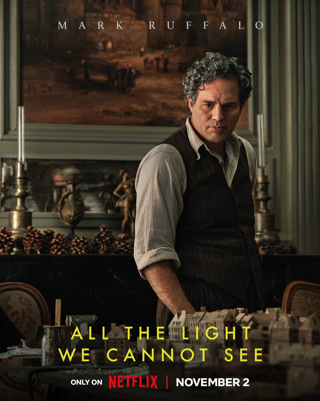
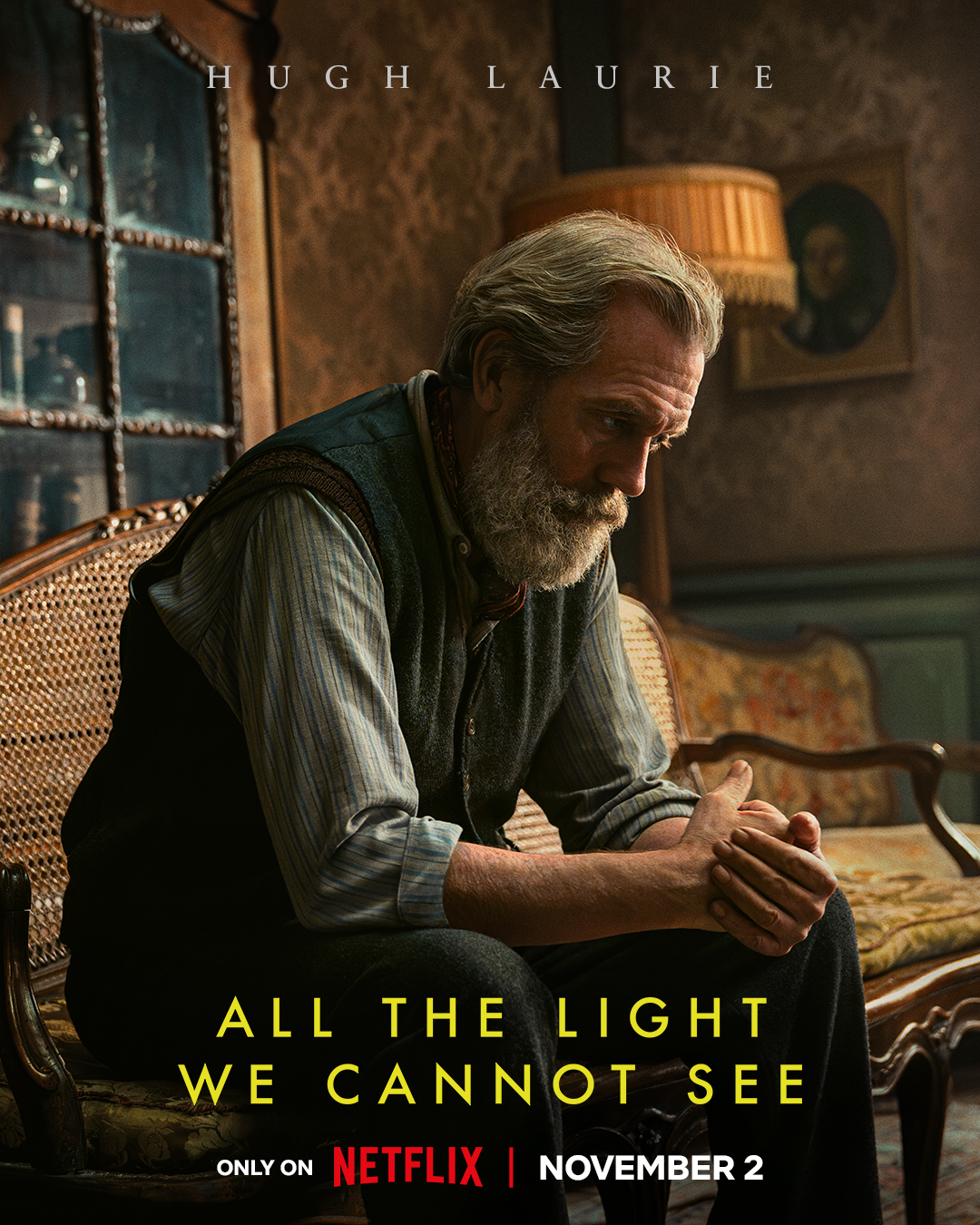
The movie stars other, more familiar actors, too. Wisconsinite Mark Ruffalo plays Daniel, Marie’s father. Hugh Laurie plays the reclusive uncle.
From being privy to episode 1, I can tell you that if you loved the book, you’ll love this series! I still can’t quite believe that I was invited to this preview.
Then the screening and conversation was over. Just as mysteriously, my internet reappeared at that instant. It made me wonder how many people got invited to this “exclusive” screening, anyway?
Unlike the man on Doerr’s train, I did not get unreasonably angry when my technology stopped working. I did get stressed out though, because I didn’t want to miss the screening. The irony does not escape me that my cell phone worked while the train man’s didn’t. And for that, we have to thank the miracle of invisible light that can pass through walls.
The online entry for the part of the Gitchi-Gami State Trail from Gooseberry Falls State Park to Split Rock State Park along Lake Superior said, This trail segment has steep hills and curves that can be particularly arduous for recreational use.
The warning was in italics and demanded attention. Russ and I looked at each other and shrugged. “Meh. How hard can it be?”
Will we never learn?! Spoiler alert: Actually, it wasn’t that bad, but a few of the uphills toward the end of our round-trip tour did defeat me, and I walked them. Just a reminder that I am 60 years old, so you gotta cut me some slack.
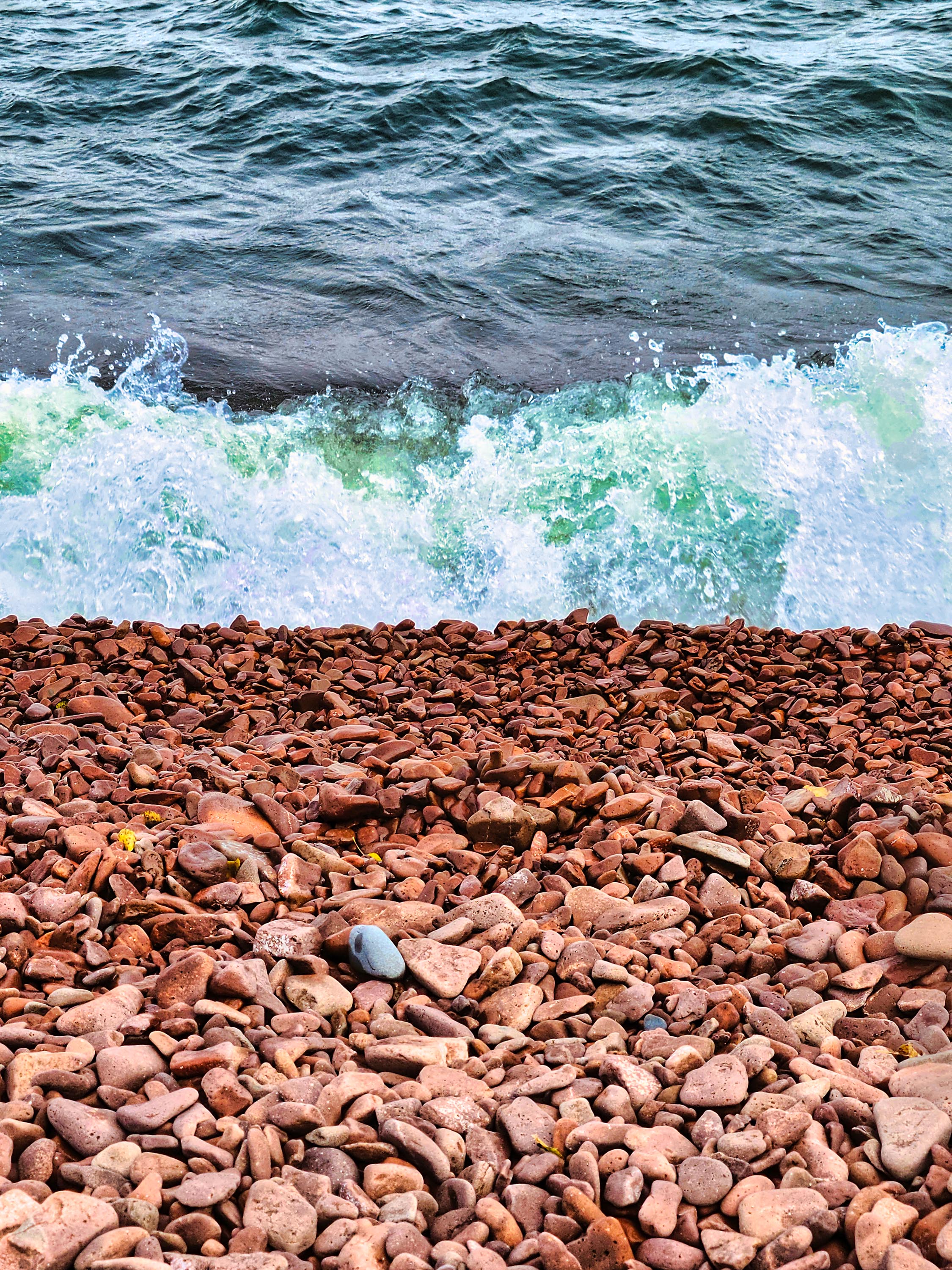
But the arduosity was worth it to bike a new (to us) segment of this trail on the North Shore and to see Iona’s Beach – a fabled shore littered with pink stones.
The Gitchi-Gami trail is composed of several paved segments totaling 33 miles. Eventually, it will span 86 miles from Two Harbors, MN, to Grand Marais, MN. I’d been on a segment north of the Gooseberry-Split Rock previously and enjoyed gliding through the birch and aspen forests and crossing river bridges.
The Gooseberry River before the falls on a foggy day.
After buying our MN state park pass at Gooseberry, we made our way to the trailhead, which is near the picnic area. The trail begins by taking bicyclists in the wrong direction – you travel south for a bit, but once you get near the park entrance it turns north. Cyclists get a spectacular view of the head of the Gooseberry River falls. In about 3 miles the trail winds into Twin Points Safe Harbor and Iona’s Beach Scientific and Natural Area. Fog from the lake rolled in and out along the way.
Iona’s Beach
We stopped and explored Iona’s Beach. Probably because of the mist, it wasn’t very crowded, but that was okay with us.
As you can see from the photos, the beach really is composed of pink stones. The stones have eroded from waves and frost from a nearby cliff (made of rhyolite) and are kept in place by dark basalt rock headlands on either side.
We sat by the water to see if we could hear the beach “sing.” When waves recede from the cobblestones, the stones come to rest with a tinkling sound unique to this beach. Waves were plentiful during our visit – the sound was subtle, but I do think we heard the beach sing!
The beach is named after Iona Lind, whose family bought the area and ran a resort there for more than 50 years. Iona ended up protecting the lakeshore she loved permanently by donating it to the state.
We continued on our way, gaining a close view of the rhyolite cliff from a bridge. A small waterfall cascaded down its face. The Split Rock River was another inspiring site. We made it a few miles into the park before my legs begged me to turn around, so we headed back to Gooseberry Falls. We did not make it all the way to the famed Split Rock Lighthouse.
All total, our trip was 15 miles. We were famished by the end of it. We wanted to eat at Betty’s Pies outside of Two Harbors, but it was so crowded that we opted for Blackwoods in Two Harbors. A mushroom and swiss burger never tasted so good!
The rhyolite cliffs that formed Iona’s Beach
FYI – Minnesota also has a black beach farther up the Shore in Silver Bay. It’s not natural, however. It’s created from discarded taconite tailings from iron ore mining activities. According to media reports and info from friends, it’s not that healthy to regularly play around on a beach made from industrial pollution, but a visit or two is just fine. The beach has been cleaned up in the past, but I would still be cautious if you have young children or have immune issues. Maybe opt for a natural pink beach instead.
Me, happily ricing, unaware of what lies ahead. Image credit: Wisconsin Sea Grant
I had a chance to harvest wild rice in the St. Louis River near Duluth recently for work. It wasn’t the first time I’d been ricing, but it’s the most memorable.
You can read about my little adventure on the Wisconsin Sea Grant blog through this link. Enjoy, and happy meandering!
Rain moved in on our last full day at Pictured Rocks. It foiled our morning plans to hike from our campground (Hurricane River, Lower Loop) to the Au Sable Lighthouse, a 3-mile round trip. But after Russ and I read and were generally slothful, the rain stopped in the afternoon and we were able to hike.
The “trail” to the lighthouse is more like a gravel road. In fact, the park employees who staff it drive on it with their car. It’s mostly level and easy walking along the shore of Lake Superior. Several shipwrecks lie on the beach near the lighthouse, but we couldn’t access them because of the rough waves.
The treacherous sandstone makes up Au Sable Point.
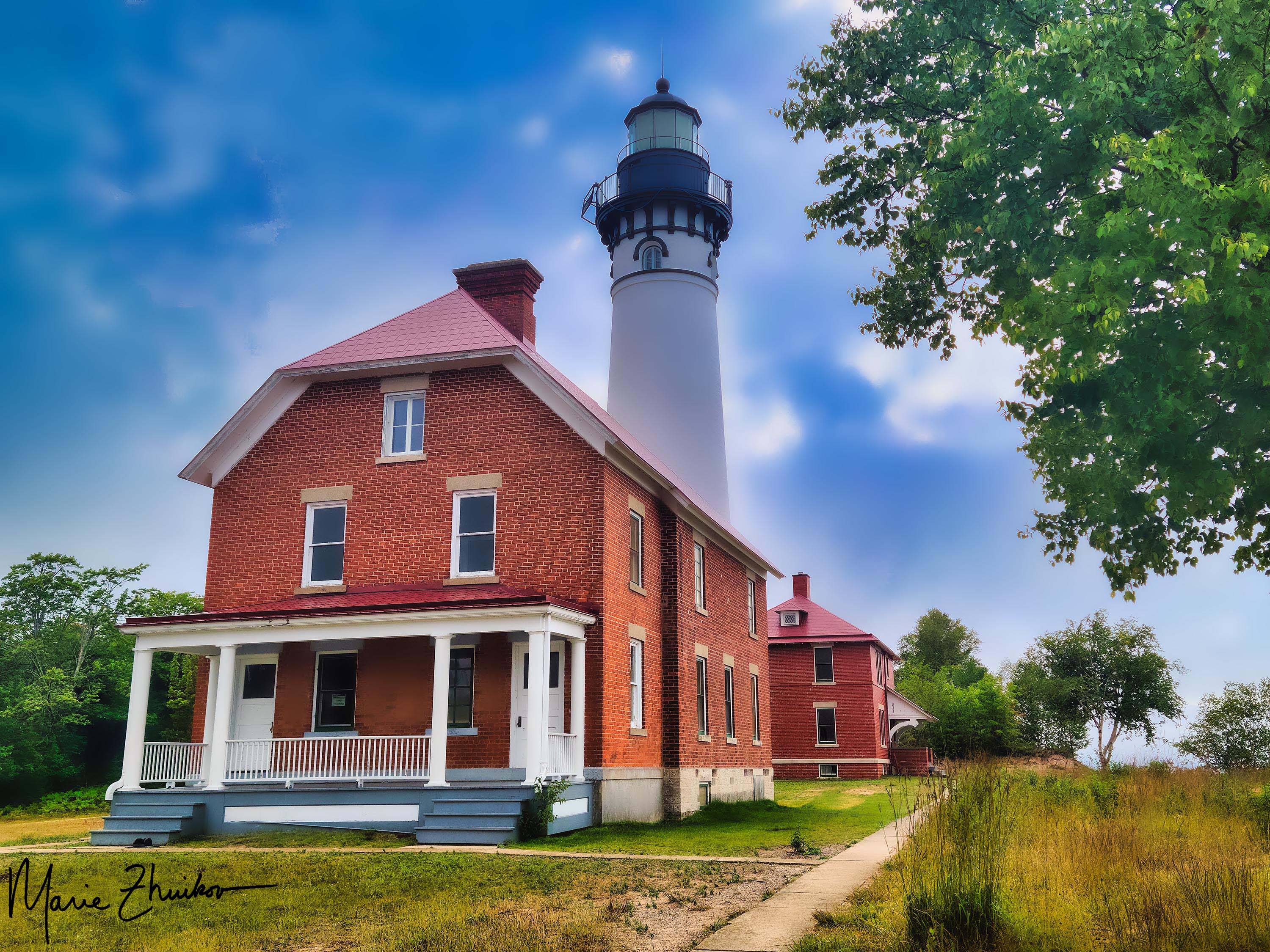
The light station is comprised of a small museum, the lighthouse and keeper’s quarters, a foghorn signal building, two historic outhouses (plus one the public can use), and a small brick oil building.
I’d wanted to visit this particular lighthouse for several years – ever since I discovered it’s the twin of the lighthouse on Outer Island in the Apostle Islands National Lakeshore. I would like to set a novel in the Outer Island lighthouse but was unable to tour inside it, so the Au Sable Light was the next best thing! Tours are offered during the summer for $5.
With its underwater reefs and thick fogs, Au Sable Point is a hazard to Lake Superior mariners. The lighthouse was built in 1874, the same year as the Outer Island Lighthouse. The light tower is 86 feet high. In 1945, the U.S. Coast Guard took over operation, replacing civilian keepers. In 1958, the Coast Guard converted the light station to an automatic, unattended light and discontinued the fog signal. The station became the property of the park service in 1968. The Coast Guard maintains the small LED beacon and solar panel that charges its battery. The park has completed several restoration projects over the years.
The Au Sable Lighthouse as the fog rolled in.
The furnishings inside the lighthouse are not original, but they are of the appropriate time period. The keeper’s quarters consist of a kitchen, dining room, living room, bedroom, work room and several closets. The lighthouse tower can be accessed directly from the living quarters.
The second floor of the keeper’s quarters is much like the first and was built for the assistant keeper’s family. Tours include a trip up the 90 steps to the top of the tower, with its impressive view of Lake Superior and the surrounding forest.
After the tour, Russ and I wandered the grounds (with me taking photos). As we prepared to leave for the hike back to the campground, a fog rolled in, completing the ambiance.
Our evening plans included a drive to Munising to trade in our Spam camping food for more elegant fare. We made reservations at Tracey’s at Roam Inn. It was pricey, but the food was worth it! I had the Lakeshore Pan Roast – a seafood stew made with lobster, whitefish and scallops in reposado cream (made with tequila). Russ had the Grass-Fed Bison Filet Mignon. You can choose three different ways for your meat to be prepared. He chose the “House” method, which involves covering the meat in pepper and serving it with mashed potatoes, birch syrup asparagus, and morel mead cream. If you like pepper, this is the dish for you.
The Lakeshore Pan Roast from Tracey’s Restaurant in Munising, MI.
Both of our meals were luscious and provided the perfect end to a wonderful trip. For dessert, Russ had the chocolate cake (served with raspberry sauce and whipped cream), and I had the crème brulee served with lingonberry sauce and a stroopwafel (a Dutch waffle cookie with caramel filling). This put our meals over the top!
Chocolate cake for dessert.
As we dined, we reflected on our experience. I was tickled by how excited people became from seeing “rocks.” On our sunset cruise, they were taking selfies with the various rock formations as well as cell phone videos to share with friends. Calling the Pictured Rocks National Lakeshore “just a bunch of rocks” (like our church friend did) was like calling the Grand Canyon “just a big hole in the ground.”
The next day, we would drive home with our Scamp. But we would do so filled with a new appreciation for an area we had driven past many times but never had time to visit.
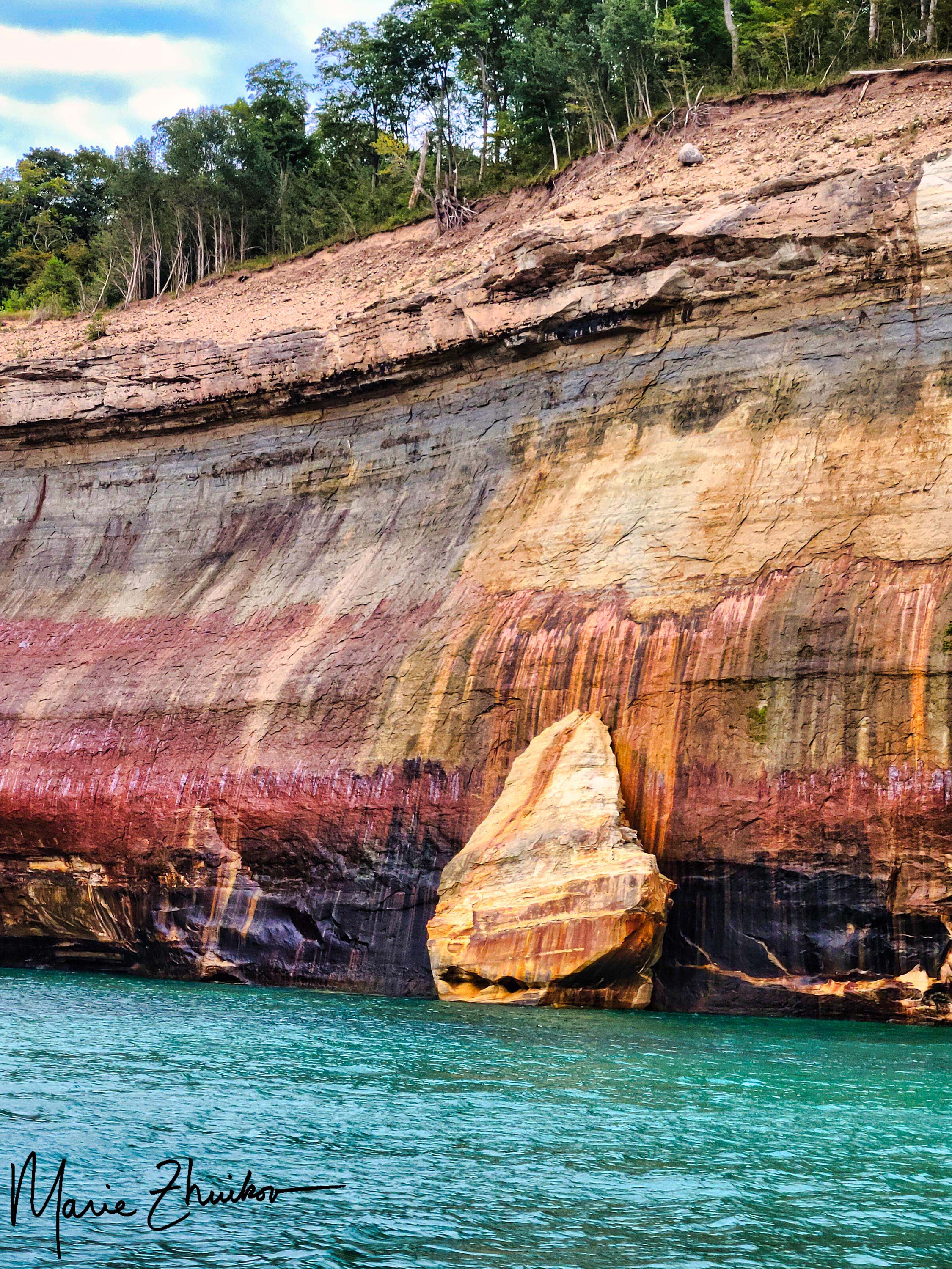
One of my favorite images from the Pictured Rocks sunset cruise.
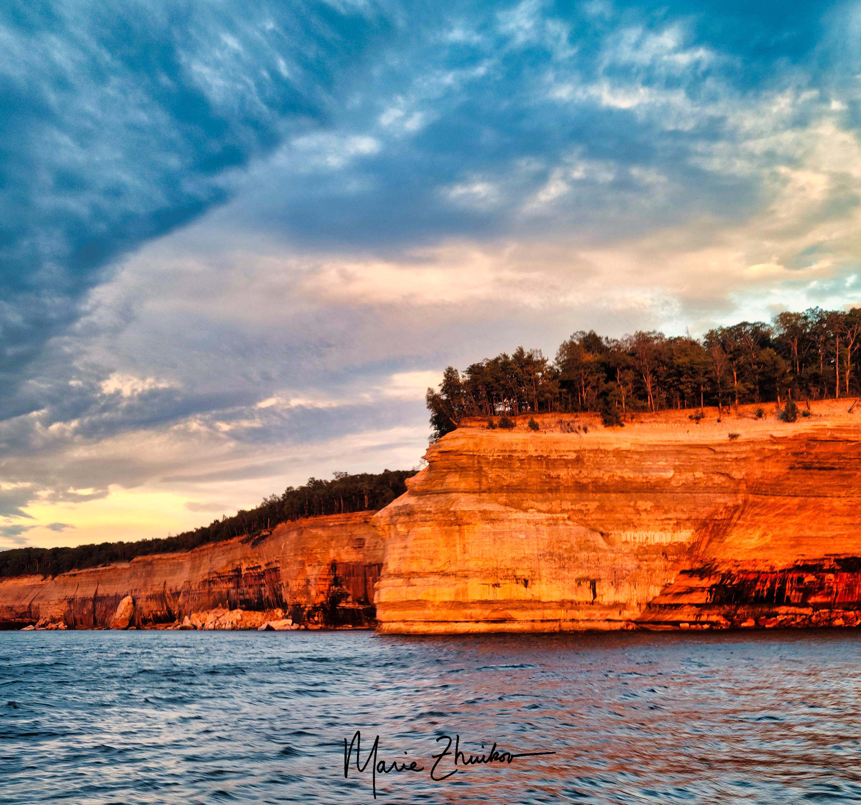
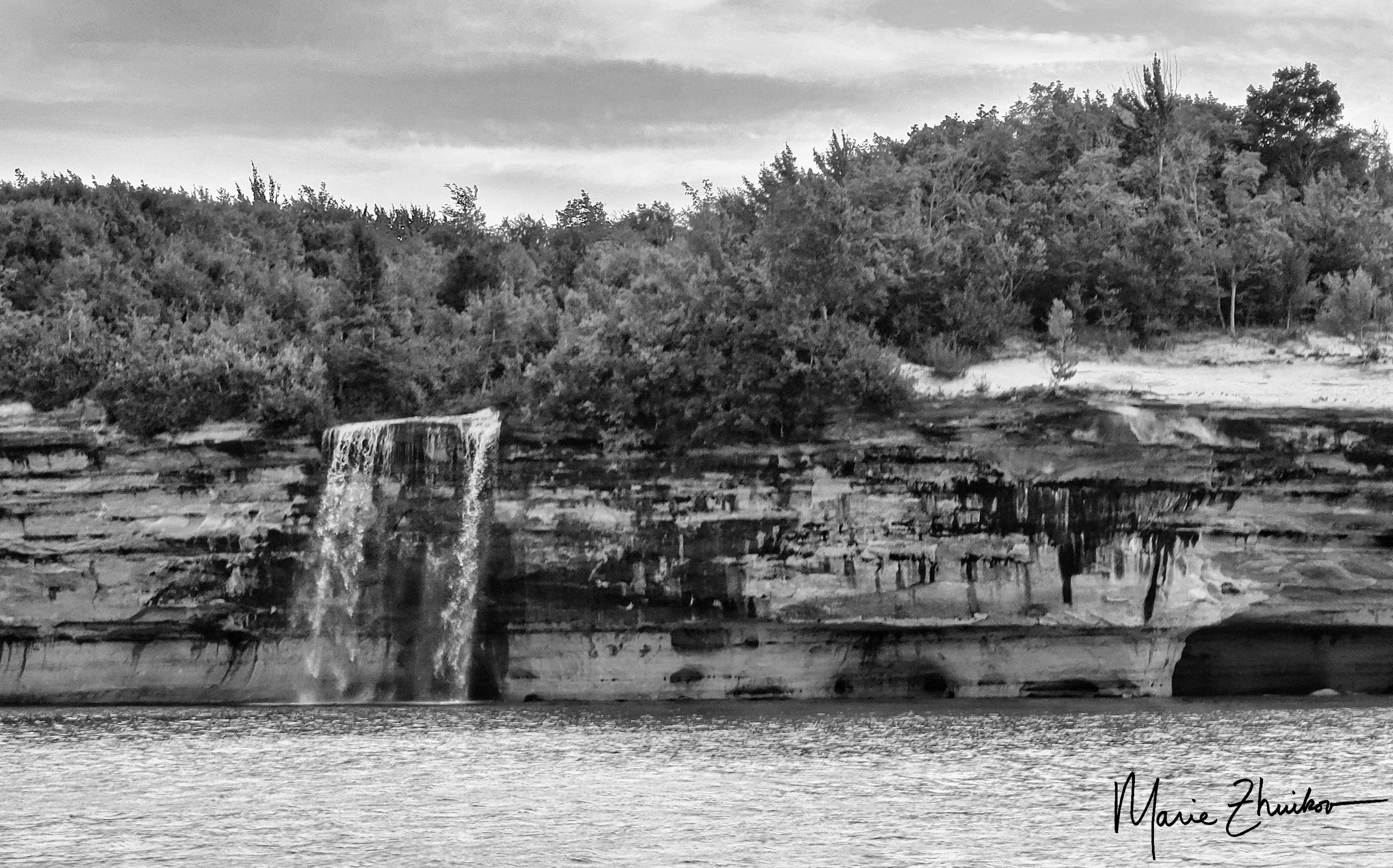
Pictured Rocks National Lakeshore in Michigan has plenty of wonderful overlooks across Lake Superior with great views (for some, see my previous post here).
But the best way to see the sandstone rock formations is via boat. Russ and I took a sunset cruise the first full day of our trip. We knew the weather would be changing to rain the next day, so we didn’t want to miss the opportunity for good photos.
Our particular cruise left from the town of Munising. Although we arrived at the cruise dock early, apparently, we weren’t quite early enough. A huge line had already formed.
Pro tips:
Make a reservation a few days in advance for your cruise to ensure you can experience it on the day you want.
Arrive at the dock more than a half-hour early to ensure you get a good seat. Good seats for taking photos are toward the front of the top deck, which is open to the elements.
There were so many passengers, the cruise line ended up fitting us onto two boats. Russ and I nabbed seats in the middle of the top deck. Not ideal, but not that bad, either.
The captain wouldn’t let people stand up to take photos, so when we neared interesting rock formations, I had to go downstairs to the viewing platform on the back of the boat where photography was allowed.
The sunset was colorful, but even more impressive was how it reflected off the rock formations. Although the sunset cruise costs a bit more, it’s worth it for the added colors.
If there’s some way you can get out on the water in a canoe or kayak, that would be even better for taking photos, but we didn’t have time for that.
Next up: a lighthouse tour and a sumptuous meal in Munising.
Sunset over Lake Superior on our first evening camping.
When I mentioned to someone at church that Russ and I were planning on camping at Pictured Rocks National Lakeshore in Michigan, the fellow said he thought the place was overrated.
Shocked by his unusual opinion, Russ and I talked about other things with him for a bit until I had to ask why he thought it was overrated. “It’s just a bunch of rocks,” he said.
We managed to keep straight faces for the rest of the conversation, but during our Scamping trip a couple of weeks ago, it was our favorite thing to say whenever Russ and I saw one of the spectacular Jacobsville Sandstone formations in this park along Lake Superior.
We camped for three nights at the Hurricane River Campground (Lower Loop). We chose that from several other options because of its close proximity to Lake Superior plus a trail that leads to a lighthouse I’ve wanted to see ever since I learned that it’s the twin of the lighthouse in the Apostle Islands where I want to set a novel.
After a 6-hour drive from Duluth, we set up camp just in time to catch the sunset over Lake Superior. We were driving around the campground, looking for drinking water, when we caught a glorious orange glow coming through the trees. I made Russ stop the car and let me out. I ran with my camera to the rocky beach. By that time, the orange had muted to a purple-blue-orange, but I still managed to get one worthy shot.
Twelvemile Beach
The next morning, we headed out early on our bicycles. We pedaled 5 miles on the scenic, twisty-turny highway and a gravel road into Twelvemile Beach Campground. (Warning: if you do this, be prepared for hills!) Although we were perfectly happy with our campground, this one had gorgeous sites strung out along a sandy lakeshore with huge pines. If we end up returning, we’ll try this one next.
Once we biked back to our campground, we spent some time wading in Lake Superior to quiet our strained calf muscles. After lunch, we drove 12 miles to Grand Marais to resupply our ice and firewood. This quaint town reminded me of Grand Marais, Minnesota, on the lake’s North Shore in many ways, except that the beach is sandy instead of rocky.
Russ was eating cherries and spitting out the pits as we drove along. I hereby apologize to the citizens of Grand Marais for his littering. If cherry trees someday spring up in town, you’ll know who to blame. 😊
On our way back, we stopped at Sable Falls, which requires 168 steps down a stairway and another 168 on the return trip. The sight was worth it – the falls are beautiful! They come from the outflow of Grand Sable Lake. (Sable is the French word for sand.) A short way down the road from the falls there’s an overlook for the lake. We stopped and were impressed by the lake’s size and by a heavily laden apple tree rustling in the breeze.
The lighthouse in Grand Marais, MI
Sable Falls
The apple tree at Grand Sable Lake Overlook.
Our next stop was the Log Slide Scenic Overlook. Back in the 1880s, lumbermen built a wooden chute that plunged down the steep sand dunes. Logs were sent down the chute to waiting ships for transport. The wooden chute is no longer there but the impressive dunes are. It’s said that sometimes the logs would catch fire on the chute due to the friction from the sand and wood, as well as the heat of the sun.
The view from the top of the log chute at Log Slide Overlook.
Although it’s possible to walk down the path of the chute, it’s a LONG way back up, and we decided our legs had had enough exercise between biking and stair climbing. Besides, the view from the top was impressive enough.
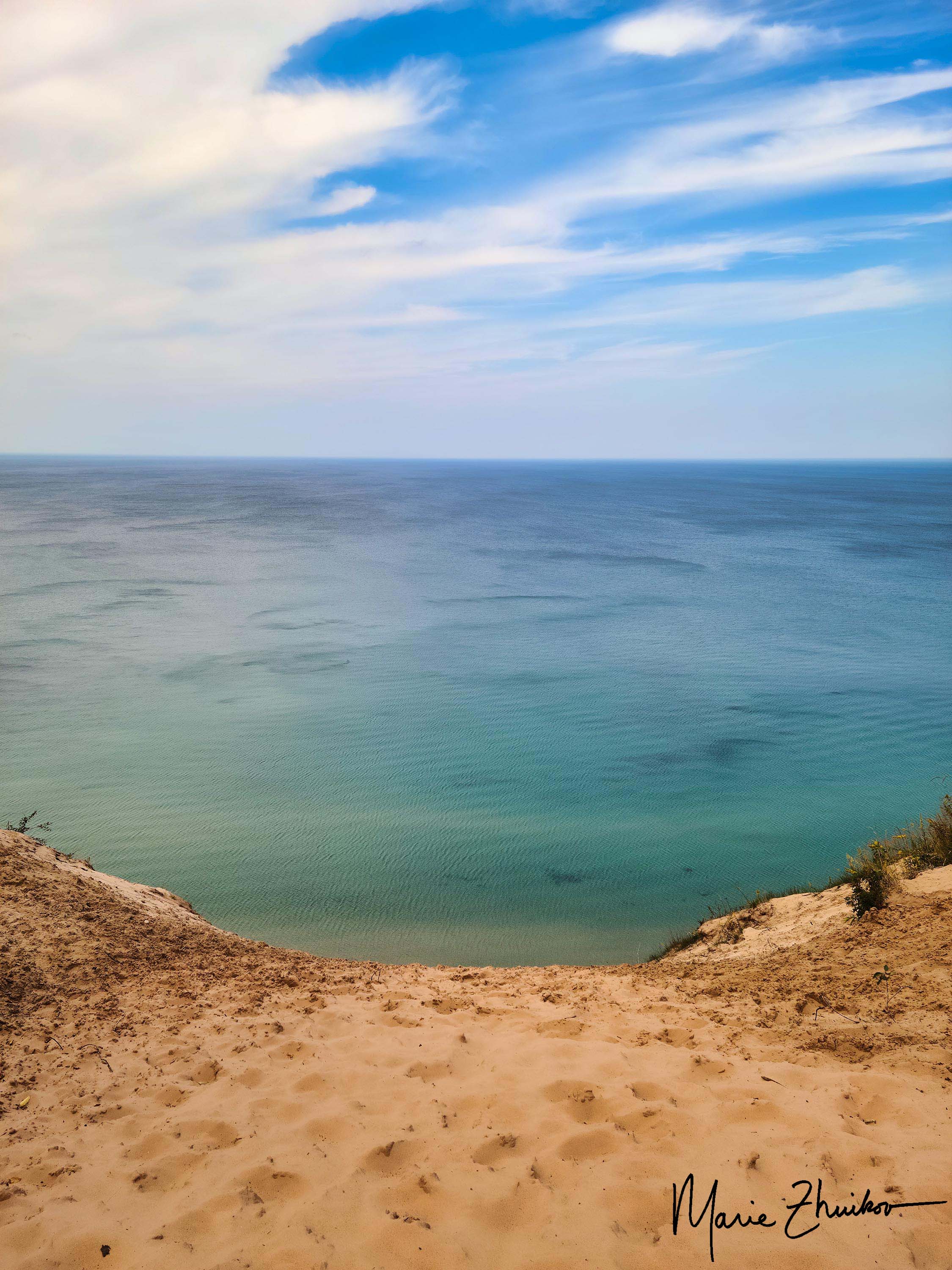
We continued our sightseeing, driving toward Munising. We stopped at Miners Castle Scenic Overlook, which features viewing platforms for an eroded rock that looks like a castle turret. The shallows of Lake Superior around the formation were a breathtaking turquoise green, making us feel like we were in the Caribbean instead of the Upper Peninsula.
Despite this, Russ and I turned to each other and said, “Eh, it’s just a bunch of rocks.” 😊
Our final stop on this busy day was a sunset cruise out of Munising, where we saw yet more rocks. More on that in my next post.