These are some of my favorite photos from New York City, but I don’t have a story to go with them. I hope they tell you their own stories.


These are some of my favorite photos from New York City, but I don’t have a story to go with them. I hope they tell you their own stories.

The unicorn in captivity tapestry.
On our recent trip to NYC, Russ and I discovered there are unicorns in the city. Specifically, unicorns adorn tapestries in The Cloisters, a branch of The Metropolitan Museum of Art devoted to medieval European art.

The Met Cloisters
Atop its hill overlooking the Hudson River, The Cloisters takes visitors back to another era. Many of the buildings and chapels were transported over from Europe. They house sculptures, paintings, sarcophagi, stained glass and other master works from the 12th century to the 15th century. The halls are separated by courtyard gardens and outdoor gardens that will make you feel like you’re on the set of Romeo and Juliet or something.
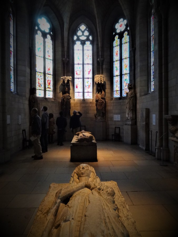
One of our favorite rooms held the unicorn tapestries. These seven wall hangings were thought to be woven in the 1500s in Brussels. They depict the hunt and capture of a unicorn. The unicorn does not fare well with its encounter with humans. It’s held captive and killed. Or is it killed? Artistic scholars debate this, but what’s not debatable in the renderings is that people attack it. But I’m not going to show those tapestries here. They are just too mean! I will show a different one, instead.

The unicorn purifies water and is discovered by the hunters.
Enjoy this mini tour of The Cloisters.


Oh, and this is a unicorn thing that does something. I don’t know what, but it looks cool.

The slurry wall inside the 9-11 Museum.
Russ and I meandered over to New York City last week. We didn’t plan it, but our trip ended up being 9-11 themed. Our first experience was a visit to the 9-11 Memorial and Museum.
The dim lights and the quiet struck me as we entered the museum. This was hallowed ground. Visitors treaded lightly and spoke softly. We met our tour guide in the lobby and she took us down, down, down into the excavation pit of the World Trade Center buildings.
 The heavy ghost of all the rubble that had filled the space and piled above it was an emotional and physical weight. Our guide showed us the slurry wall that held back the river from flooding the space, the square-edged outlines of the waterfalls that flowed in the memorial outside, the wreckage of the fire trucks, and the last cement column that survived the building collapse, festooned with first-responder graffiti.
The most awe-full artifact for me was the impact steel from the North Tower, which was the one hit first. Mounted on the wall like a crucifix with a stark light upon it, the mangled steel beams hung as a testament to the power of the plane that crashed into the building and began the nightmare.
People showed different emotions to these sights. Some were crying, some were dazed. Everyone was somber.

The impact steel from the North Tower.
Our tour guide explained that her brother worked in the World Trade Buildings. He only escaped death that day because, at the last moment, he decided to go to the optometrist to get his glasses fixed instead of heading up the tower.
Tour over, we were free to wander among the artifact exhibits on our own. I was drawn to the information about the plane that crashed in Pennsylvania, because I was in Pennsylvania when 9-11 happened. A timeline of those events was on display along with text of the plane cockpit recordings.
Also powerful and haunting were the voicemail messages left for loved ones from those who worked in the tower after the plane(s) crashed into them.
After all that heaviness, I was glad to get outside into the memorial area. But even the memorial is heavy, with all the names of the dead inscribed around the waterfalls that flow into the building pits. We found the name of a man who had been in a relative’s wedding party.
 The other 9-11-themed thing we did was attend the Broadway show, “Come From Away.” Although poignant at times, this experience was much more enjoyable than the museum. The musical tells the story of the townspeople of Gander, Newfoundland. This village of 10,000 people hosted 7,000 airplane travelers who got grounded on 9-11 for several days.
The Newfies welcome the confused travelers like only Newfies could – with generosity, caring, music, and whisky. The show offered 100 minutes of humanity and hopefulness. The audience gave it a standing ovation at the end. If you have a chance to see “Come From Away,” by all means, do so!
 My story, “Tuscarora Enchantment,” is in the latest issue of the Boundary Waters Journal. It’s the first article I’ve written for them in many years, and it’s good to be back!
The story is based on the experience that Russ and I had during our trip that I mentioned in this blog last year. We took one of the most rugged routes in the wilderness, retracing steps (and paddling) I took in college with my newspaper reporter cronies.
You can look for the fall issue on newstands or you can order my article for a nominal fee direct from the magazine. Follow this link for info about how to do that: https://www.boundarywatersjournal.com/archives

A ship waiting to go through the U.S. locks.
I meandered on over to Sault Ste. Marie, Michigan, (also known as the Soo) last week for a work conference. This town is at the opposite end of Lake Superior from my hometown of Duluth. It’s the site of the St. Marys River, which drains Lake Superior into Lake Huron. The international boundary between the U.S. and Canada runs its length, and the river is also home to the locks that raise and lower cargo ships, allowing them to travel between the two Great Lakes.
 I had the opportunity to see the locks on this trip from both the American and Canadian sides. The differences were startling. To approach the American locks by foot requires an inspection of one’s bags by Homeland Security. The locks are surrounded by impressive fencing and warning signs. I suppose this is the result of 9/11, and the security makes sense since I believe the American locks are larger and most of the valuable shipping traffic goes through them. The surrounding park is manicured and heavy industrial equipment lies at the ready atop the lock walls.
The Canadian locks run on the other side of the St. Marys River near Whitefish Island, which is a nature preserve in the river. Those locks are less developed and no security checks are required. The island they are part of is home to beavers, muskrats, and duckies, and trails abound for nature-loving humans.
I had a chance to walk around the island and take some photos. The neatest thing my co-worker and I saw was a muskrat swimming underwater. S/he was apparently building a nest under the boardwalk we were standing on, and we watched the brown torpedo-like animal swim back and forth several times, carrying aquatic grasses to its lair.

A beaver house near the Canadian locks.
Now I am home again. I am glad to be staying put. No more meandering for me for a while.

The Canadian locks.

A duck on the Canadian side. The water is very clear!
 Russ bought a 13-foot Scamp trailer about a year ago and we hadn’t had time to use it until now. Scamps are cute little lightweight campers made in Minnesota. Ours has all the comforts of home in a compact space. The only things missing are a bathroom and an oven.
I needed to travel overnight for a freelance magazine story assignment in Canada, so we decided it was the perfect opportunity for the Scamp’s maiden voyage.
On our way to the Dawson Trail Campground in Quetico Provincial Park, we left Duluth and drove across the border on the North Shore of Lake Superior with our two doggies. Note that to bring your dogs into Canada, you need to have a rabies vaccination certificate. The border agent didn’t ask us for our dogs’ certificates, but we had them along, just in case.
Just outside of Thunder Bay we turned north to Kakabeka Falls. Since the falls are close to the road and we’d never seen them, we decided to stop. At 131 feet, these falls are even higher than the ones on the Pigeon River on the border of Minnesota and Canada. They are truly spectacular and well worth pulling off the highway to see.
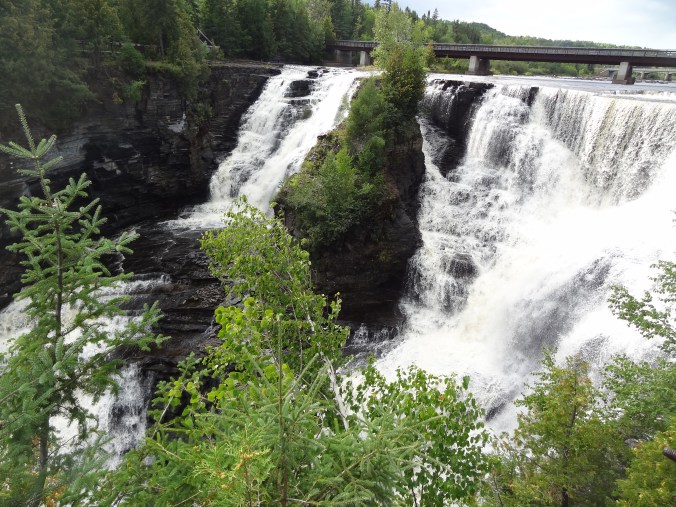
Kakabeka Falls
Then we were off to find the Trans-Canada Highway. This impressively maintained road looks totally out-of-place as it takes drivers past pine-lined undeveloped lakes, bogs, and beaver homes. Imagine the Boundary Waters Canoe Area Wilderness with a freeway through it, and that’s what driving this stretch of Highway 11 is like.
There are not many services along the road in this part of the world. In fact, warning signs advise drivers to check their gas at certain points because if you run out, you’ll be stuck in the middle of nowhere.
Counting a lunch stop and the waterfall stop, it took us about eight hours to arrive the campground. The campground is actually two campgrounds, a canoe launch, several log cabins, a visitor center, picnic grounds and a bunch of hiking trails.
We parked our Scamp in Ojibwa Campground, which features a small beach, electric hookups, and a bathroom building that offers free hot showers and a coin laundry (if you bring some loonies along). As we checked in, the ranger warned us of bear activity in the campground. The park had a cage trap out to catch it.
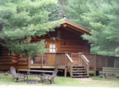
A log cabin for rent at the campground. Pretty sweet!
We stayed for three nights, discovering along the way that yes, you can fit two adults and two large dogs into a 13-foot Scamp.
After my writing work was done on our last day, we took a hike to The Pines, which is a picturesque beach lined with a stand of red pines. After being spoiled by hiking among giant hemlocks in the Apostle Islands last fall, we were a bit disappointed by this hike. From the descriptions, we expected giant pines to line the trail, not only the endpoint. And the pines weren’t all that old. But don’t let our expectations stop you from exploring the area – we are just nature snobs, I guess.
Our doggies loved the beach, however. Buddy the Wonderdog ran in crazy circles, he was so excited to have reached this sandy destination. Russ’s dog Bea waded into the water and drank her fill from Pickerel Lake.

The Pines at the end of The Pines trail.
During our hike back to the campground, a drizzle started to fall. We slogged along for several hours and were super happy to have a dry and cozy Scamp to climb into at the end of it. With my only pair of jeans sopping wet, I took advantage of the dryer at the bathroom and was soon able to climb under a blanket in dryer-warmed pants. This truly felt like a magnificent luxury in the wilderness.
While I was gone on this task, Russ said he saw the campground bear being driven away, trapped in the cage.
Our route back home took us farther west along the highway to Fort Frances and International Falls, where we crossed the border back into America again. Once we crossed the border, the dogs, still worn out by the hike the previous day, perked up. Russ and I joked that it was like they could smell America.
If you’re thinking of upgrading from tent camping to a Scamp, I would say, do it! We are looking forward to our next Scamping adventure. I wonder where it will take us?

The beach at Ojibwa Campground and canoe landing.
We recently returned from an epic road trip straight south. Our mission? To take my youngest son to college in Arizona. He wanted to have his car with him at school, so thus the necessity of driving it 1,700+ miles.
It’s been a while since I’ve taken a long road trip and I was looking forward to it. I’d also never driven across Kansas or Oklahoma before, so was itching to cross those states off my driving list.

Photo taken by Hunter Zhuikov, somewhere along the Kansas Turnpike.
Two themes soon emerged: free stuff and boring geographic names.
The free stuff started with our first lunch while we were still in Minnesota. We stopped at a Perkins Restaurant. Unbeknownst to us, Mondays are free pie days at the chain. Our waitress thought that everybody knew this and that’s why we stopped there. When she announced our free pie choices, we just stared at her in dumbstruck wonder. Afterward, we continued our drive, fortified by a few hundred extra free calories.
Our luck continued that night in Kansas City where we ate at a Red Lobster for supper. Due to a computer glitch, our food order did not make it to the cooks in a timely manner, so, even though we weren’t upset by the wait, the manager offered us a free dinner and two desserts. More free food, yippee!
The next day our luck changed from food to transportation. We were at a tollbooth on the end of the Kansas Turnpike when the machine malfunctioned. The toll operator let us pass through without paying because it was going to take too long to reboot the machine. Yeehaw!
We thought our luck was over when no free stuff appeared for the next 24 hours, but we were wrong. On our third and final day of the trip, we decided to stop at White Sands National Monument in New Mexico because it was right next to the highway and it looked picturesque. We could only spend about a half-hour there, however, because relatives were waiting for us in Arizona. As we drove up to the entrance fee booth, we noticed it was empty. Yay! Free scenery!

White Sands National Monument
If you ever get the chance to visit White Sands, be sure to do so. The piles of white gypsum flow in spectacular dunes, which you can access right off the park road. We had enough time to drive to a boardwalk trail and hike to the end of it, taking photos along the way.
Now for boring geographic names. C’mon Kansas, you can do better. Examples: there’s a town named Rock, another named Urbandale. How generic can you get? A river called Whitewater. Another town named Grove.
Ugh. As if driving through farmland isn’t already mind-numbing, the place names in Kansas, at least those before Witchita, were totally uninspiring.
After Witchita, things changed. We ran into town called Smoots. Another called Pretty Prairie. That’s better, Kansas. Keep it up! We crossed the Ninnescah River about three times. I probably liked this name because it sounded Minnesotan. Thank goodness the place names got better or I might have fallen asleep behind the wheel.
Other things of note: We passed the world’s largest hand-dug well in Greensburg, Kansas. We did not stop, but maybe we should have. I mean, the thing has its own visitor center, it’s so huge! We also passed the world’s largest pistachio. This was in New Mexico. It’s not a real pistachio, but a “mammoth outdoor sculpture” to advertise a pistachio tree ranch. We didn’t stop there, either, having already used all our spare time at the White Sands.
We were also impressed by all the wind turbines in Kansas and Oklahoma. It seems as if wind power is alive and well in those states.
I am happy to report that my son’s car survived the journey, and so did we! My son is ensconced in his dorm room and starting his classes now. Once we flew back home, the house was eerily silent without his presence. We are still adjusting.

Moving into the dorm.

Arroz marinero at Casa del Marisco.
We meandered down to Orlando, Florida, last week for a work conference. We stayed at a huge hotel with almost 3,000 people just for our conference, plus thousands of others who were attending other conferences held there.
The hotel housed half a dozen restaurants, but they were incredibly noisy. After a couple of days of hoarse voices from talking over other people, we decided to venture off-site for dinner. After a quick Google search for nearby places, we decided on Casa del Marisco, a seafood restaurant that features Peruvian and Ecuadorian seafood.
The worry began when we arrived. The restaurant seemed to be in the basement of a repurposed hotel. By repurposed, I mean there were tattoo parlors, fast biz cash loan offerings, and other questionable business ventures.
Our sense of dread did not abate when we opened the restaurant doors and found ourselves the only customers. The restaurant was white and clean, yes, but with its mirrored walls and tiled floors, the ambiance harkened back to the 1980s.
We were quickly greeted and seated, however. After perusing the menu, I looked up and could see through a window into the kitchen. The cooks looked like they could be Mexican or Edcuadorian. I suspected that this dining experience could be either very good or very bad.
Our waiter was friendly, and it was obvious that English was a second language to him.
I chose the arroz marinero, a paella rice and seafood mixture served with fried plantains. It arrived as pictured above, with healthy doses of mussels, shrimp, squid and scallops. As my dining companions enjoyed their dinners, it didn’t take long for my taste buds to realize that this was going to be a great dining experience!
The rice was zesty, but not too spicy for my Minnesota palette, the seafood was not overcooked, and the plantains were tender and sweet.
Only one other person entered the restaurant during our dinner, and that was to wait for a to-go order. But the kitchen staff was busy, presumably making other to-go orders. An “uber pick-up” sign made us think the place must do a good take-out business.
When the check arrived, the numbers were in Spanish, with a comma where the decimal point should be. It all seemed thrillingly ethnic to us northerners.
So I am here to say, don’t let the appearance of this place put you off. The food is worth the retro ambiance. In fact, some people might even like the ambiance, since the 1980s are hip once again.

The bridge across Big Bay Town Park lagoon. Look at that beautiful water!
My friend Sharon and I meandered onto this island in Lake Superior a couple of weeks ago. We’d both been there before, but found two cool new places to explore this time. And I mean “cool” as in awesome and interesting.

The lagoon.
The first was Big Bay Town Park, which friend recommended to us. Unlike with the state park on the island, the town park has a free-will donation fee. A short walk down a stairway from the parking lot leads you to a bridge across a stunning lagoon that enters Lake Superior. On the other side of the lagoon is a public beach studded with white pines. The water is crystal clear and inviting, although as always with Lake Superior, temperatures may be a bit cool.
Canoes are available to rent via self-service onsite, or you can rent watercraft, including paddleboards from a place in town. The kayaks, canoes, and paddleboard are all onsite, and the businesses will give you a key to unlock them.
I brought my own blow-up paddleboard and Sharon rented one for two hours. We cruised the lagoon, watching painted turtles walk across the sandy bottom and startling a fish here and there. The water is so clear, it felt like we were flying through it.
 The second place is Tom’s Burned Down Café. I’d seen it from afar before and heard about its, shall we say, counterculture reputation. Maybe it once was a café (before it burned down?) but now it is a bar. No food is available.
The place is a hodgepodge of homegrown-construction seating areas held together with signs with sayings like “It’s not premaritial sex if you don’t plan on getting married,” and “Be the rainbow in a world full of rain.” The top is covered by several tents.

Tom’s Burned-Down Cafe
Sharon and I sat down, thirsty after our paddleboard, and ordered margaritas. The friendly bartender asked us if we’d like to try beet-infused tequila in our margaritas, pointing to a large glass container of mysterious red liquid behind him.

My beet-infused margarita with the hand-written menu behind it.
We hesitated for a few beats, and then agreed. We were already brave enough to come into the bar, why not be even braver and try something new? The beet margarita was definitely drinkable, but it didn’t have as much lime in it as we were craving.
Also of note is that the place is cash-only. If you don’t have any, an ATM is available (under its own small tent) in the bar.
Tom’s was named the Number 2 Best Beach Bar in America in 2013 by Maxim Magazine, no doubt, for its unusual ambiance. If you go there with a sense of adventure, you won’t be disappointed!
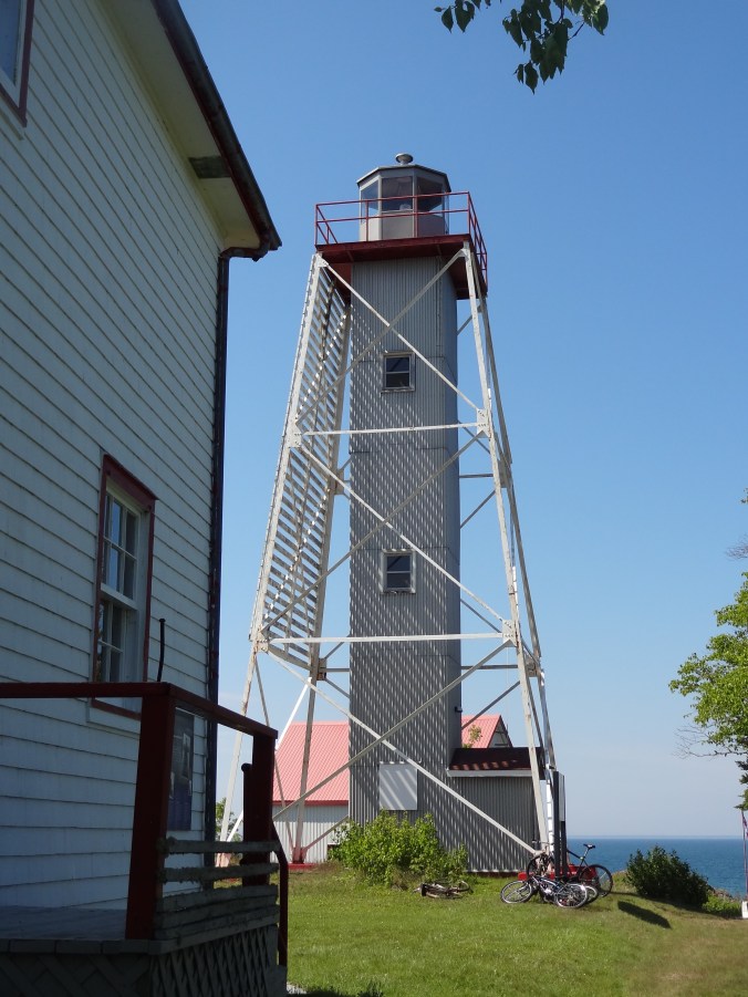
Porphyry Island Lighthouse
Porphyry is a wilderness island in Lake Superior on the east side of the Black Bay Peninsula near Thunder Bay in Ontario, Canada. Most arrive by motorboat, sailboat, kayak or canoe, docking in a secluded cove about a mile away from the lighthouse. Some arrive by helicopter, alighting on the helipad adjacent to the lighthouse.
Us? We arrived by dinghy, rowing from our anchorage farther down the island. When we landed, we were met by a native Canadian lad – a volunteer for the Canadian Lighthouses of Lake Superior organization.

Did you know there’s a universal symbol for taking a sauna? We didn’t until now, either!
When he asked where we traveled from, Captain Dave told him we rowed from Isle Royale — a preposterous 29 miles away. The lad did not take the bait, and instead, graciously offered us a tour of new structures in the cove. A boathouse features a mini-gift shop, and the sauna offers promises of warmth to be dashed by a splash in Lake Superior afterward.
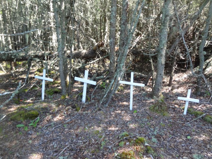
Although bikes were available, we chose to stretch our sailboat- and dinghy-cramped legs by walking the flat trail to the lighthouse. Lined with Canada dogwoods, forget-me-nots, and the mysterious devil’s club plant (readers of my novel “Eye of the Wolf’ will know what this is!), the trail passed two points of interest along the way.
One was a small graveyard. Four white crosses mark where members of a former lighthouse keeper’s family are buried. The second is an area where a couple of junker cars lie moldering, relics from when the trail used to be a road.
 Upon reaching the lighthouse, we were greeted by several more volunteers, plus Eve, a former assistant lighthouse keeper. Her husband, Graham, was the last to keep the light before it became automated. He died a couple of years ago, and a photo gallery has been set up near the lighthouse to showcase his award-winning photos.
 Volunteer Kaitlyn showed us the gallery and a small museum. She was walking us toward the lighthouse for a tour when the door of the structure groaned and burst open. A man ran out, cell phone plastered to his ear, talking intently.
After all the wilderness silence we’d experienced, this was shocking. Not only for the noise but for the technology. (We hadn’t had cell phone service in a while.) We all put our hands on our hearts, and stopped on our tracks.
The man continued walking away from us, talking on his phone. After recovering, Kaitlyn and Eve told us the man was Paul, who ran the place. Once he got off his phone, we were able to meet him. He explained his office is in a room in the base of the lighthouse. He did not explain why he had to suddenly run out of it, but one would assume it was because he was in an important conversation and needed better reception. It made me wonder if his heart-attack-inducing bursting forth happened often, and also made us feel a bit sorry that running the place has him so stressed that he can’t meld into the peacefulness of it.

The helipad at the lighthouse.
As we were speaking with Paul, an older woman laden with painting supplies walked by. She was the latest artist-in-residence at the lighthouse, a painter from Jerusalem. The lighthouse organization sponsors several artists each summer. There’s also a guest house that people can rent, which used to be the lighthouse keeper’s quarters.
After we promised to donate to the lighthouse organization, Paul deemed us worthy of a tour of the lighthouse. Eve and Kaitlyn guided us up the six steep sets of stairs, which were more like ladders. Once at the top, we admired the view of Thunder Bay’s Sleeping Giant through the windows.
After a bit, Eve asked us if we’d like to go outside on the railing. Without hesitation, we said yes. We ducked through a small opening, out into the freedom of the summer breeze. The view was stunning. Eve pointed out the other islands we could see where she had worked with her husband, and where her sons were born. She told us that when they worked at Prophyry, her sons used to enjoy dropping water balloons down the inner corridor. I could totally see how that would appeal to them.
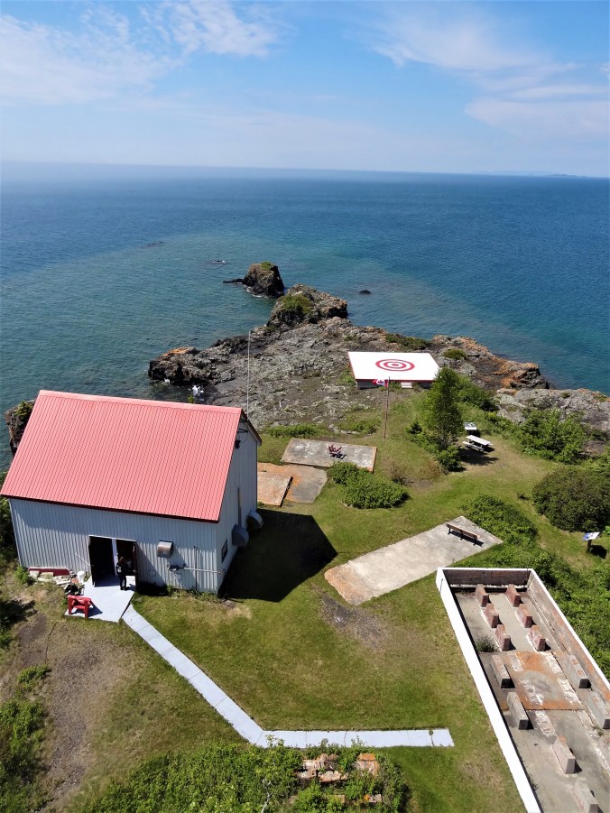
The view looking down from the top of the lighthouse.
After drinking in the view, we carefully descended the steps back to the ground. Eve, at 70, navigated them like a much younger woman. Then again, she must have had a lot of practice when she worked here.
We walked back to the cove and socialized with a Canadian sailor who was anchored there. As we rowed back to our boat, a fog started to roll in, relegating the lighthouse and its inhabitants back into the mists of time.

Eve and Kaitlyn
