Once upon a time, a woman lived alone in the northern Minnesota wilderness. Except, she wasn’t really alone. Birds and otters kept her company. Canoeists stopped by her island on Knife Lake near the Canadian Border. At one time, she even ran a resort there.
Image courtesy of the Dorothy Molter Museum.
But after the land was designated as an official roadless area and then a Wilderness with a capital W, making a living became more difficult for the woman, not to mention getting supplies. Rogue sea plane pilots tried to help her, but they were arrested. The only thing the woman could do was haul in the supplies she needed by canoe, portaging five times over the 33 miles to civilization.
In 1952, a writer with the Saturday Evening Post visited her and wrote a story about “The Loneliest Woman in America.” The article turned her into a national legend – a woman living alone among wolves and braving minus 50-degree winter temperatures. But the woman always contended the writer got it wrong, she was never lonely, even in winter.
One day, she was cleaning and found dozens and dozens of glass bottles left from when her resort served pop (as we call it in Minnesota). Rather than haul out the bottles and discard them, Dorothy Molter (as was her name) got the idea to make root beer for passing canoeists in the Boundary Waters Canoe Area Wilderness.
Dorothy Molter’s root beer cooler.
She hit the jackpot. If there’s one thing most wilderness campers appreciate, it’s a fizzy cold drink after days away from civilization. Dorothy made her drinks with root beer extract, sugar, yeast, and water from Knife Lake. They were cooled on ice cut from the lake in winter. Canoeists donated a dollar per bottle.
Dorothy made root beer for years. At the height of her business, she produced 12,000 bottles and still couldn’t keep up with demand. She was trained as a nurse and aided any canoeists who needed help by sewing up cuts and removing fishhooks from various body parts. She once saved the lives of a father and son who got hit by lightning in a sudden summer storm. Dorothy also nursed wild animals, including a crow and a mink.
A strong and plain-spoken woman, Dorothy didn’t swear or curse, but she didn’t mince words either. Her philosophy for surviving in the wilderness could be summed up in the sign she posted at her home on the Isle of Pines. “Kwitchurbeliakin,” it advised.
Dorothy continued living in the wilderness until she was in her late 70s. She kept in touch by radio, checking in with Forest Service staff daily. One winter day she didn’t check in. Then another day passed with no contact. A wilderness ranger made the trek and found her dead of a heart attack from hauling wood.
The Dorothy Molter Museum, Ely, MN
Although Dorothy’s time passed, her memory is preserved in a museum named after her in Ely, Minnesota. The fame and good will she garnered through her lifestyle prompted its formation.
Russ and I had heard of Dorothy over the years but never had a chance to meet her or visit her museum. We thought we were out of luck on a recent camping trip to Ely because a brochure we happened upon said the museum was closed after Labor Day.
With drizzly weather forecast, Russ and I ditched hiking plans and meandered into Ely to see what struck our fancy. We had driven though the whole town with no fancies struck, when we passed the sign for the Dorothy Molter Museum on the outskirts. The sign read “Open.” So, we turned in, hoping the sign wasn’t just the product of end-of-season-forgetfulness on somebody’s part.
The museum really was open! We spent a couple of hours touring Dorothy’s cabins, which volunteers had hauled out of the wilderness to house her artifacts. We enjoyed watching excerpts from a video about Dorothy’s life. We viewed her root beer-making equipment and perused the gift shop, where visitors can buy a bottle of Dorothy’s root beer. Despite the drizzle, we also got a bit of hiking in on the quarter-mile trail in the pine plantation surrounding the museum.
We left glad to see Dorothy’s memory preserved. As one of the museum signs says, “Although Dorothy has been gone from Knife Lake for over 30 years, we hope that you find inspiration to live your lives like she did, in harmony with the environment, with integrity, helping humankind, and making a contribution toward a better world.”
The online entry for the part of the Gitchi-Gami State Trail from Gooseberry Falls State Park to Split Rock State Park along Lake Superior said, This trail segment has steep hills and curves that can be particularly arduous for recreational use.
The warning was in italics and demanded attention. Russ and I looked at each other and shrugged. “Meh. How hard can it be?”
Will we never learn?! Spoiler alert: Actually, it wasn’t that bad, but a few of the uphills toward the end of our round-trip tour did defeat me, and I walked them. Just a reminder that I am 60 years old, so you gotta cut me some slack.
But the arduosity was worth it to bike a new (to us) segment of this trail on the North Shore and to see Iona’s Beach – a fabled shore littered with pink stones.
The Gitchi-Gami trail is composed of several paved segments totaling 33 miles. Eventually, it will span 86 miles from Two Harbors, MN, to Grand Marais, MN. I’d been on a segment north of the Gooseberry-Split Rock previously and enjoyed gliding through the birch and aspen forests and crossing river bridges.
The Gooseberry River before the falls on a foggy day.
After buying our MN state park pass at Gooseberry, we made our way to the trailhead, which is near the picnic area. The trail begins by taking bicyclists in the wrong direction – you travel south for a bit, but once you get near the park entrance it turns north. Cyclists get a spectacular view of the head of the Gooseberry River falls. In about 3 miles the trail winds into Twin Points Safe Harbor and Iona’s Beach Scientific and Natural Area. Fog from the lake rolled in and out along the way.
Iona’s Beach
We stopped and explored Iona’s Beach. Probably because of the mist, it wasn’t very crowded, but that was okay with us.
As you can see from the photos, the beach really is composed of pink stones. The stones have eroded from waves and frost from a nearby cliff (made of rhyolite) and are kept in place by dark basalt rock headlands on either side.
We sat by the water to see if we could hear the beach “sing.” When waves recede from the cobblestones, the stones come to rest with a tinkling sound unique to this beach. Waves were plentiful during our visit – the sound was subtle, but I do think we heard the beach sing!
The beach is named after Iona Lind, whose family bought the area and ran a resort there for more than 50 years. Iona ended up protecting the lakeshore she loved permanently by donating it to the state.
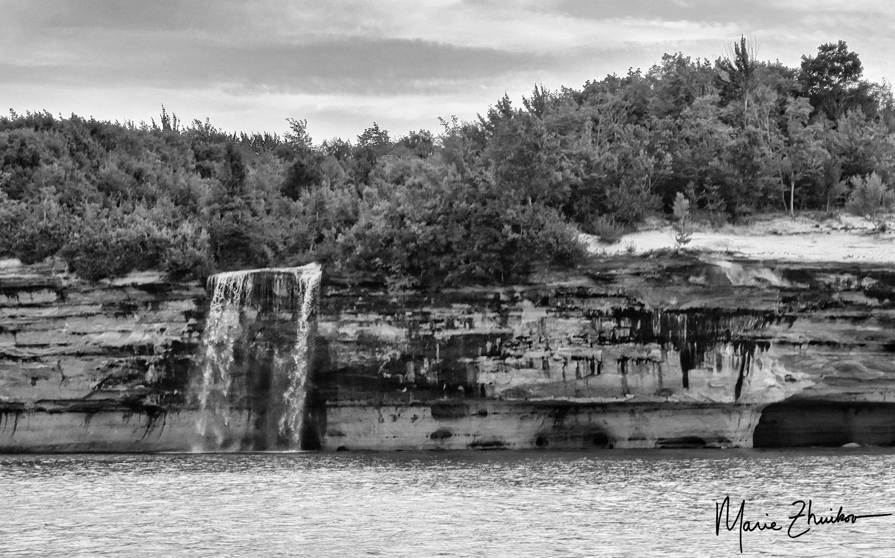
We continued on our way, gaining a close view of the rhyolite cliff from a bridge. A small waterfall cascaded down its face. The Split Rock River was another inspiring site. We made it a few miles into the park before my legs begged me to turn around, so we headed back to Gooseberry Falls. We did not make it all the way to the famed Split Rock Lighthouse.
All total, our trip was 15 miles. We were famished by the end of it. We wanted to eat at Betty’s Pies outside of Two Harbors, but it was so crowded that we opted for Blackwoods in Two Harbors. A mushroom and swiss burger never tasted so good!
The rhyolite cliffs that formed Iona’s Beach
FYI – Minnesota also has a black beach farther up the Shore in Silver Bay. It’s not natural, however. It’s created from discarded taconite tailings from iron ore mining activities. According to media reports and info from friends, it’s not that healthy to regularly play around on a beach made from industrial pollution, but a visit or two is just fine. The beach has been cleaned up in the past, but I would still be cautious if you have young children or have immune issues. Maybe opt for a natural pink beach instead.
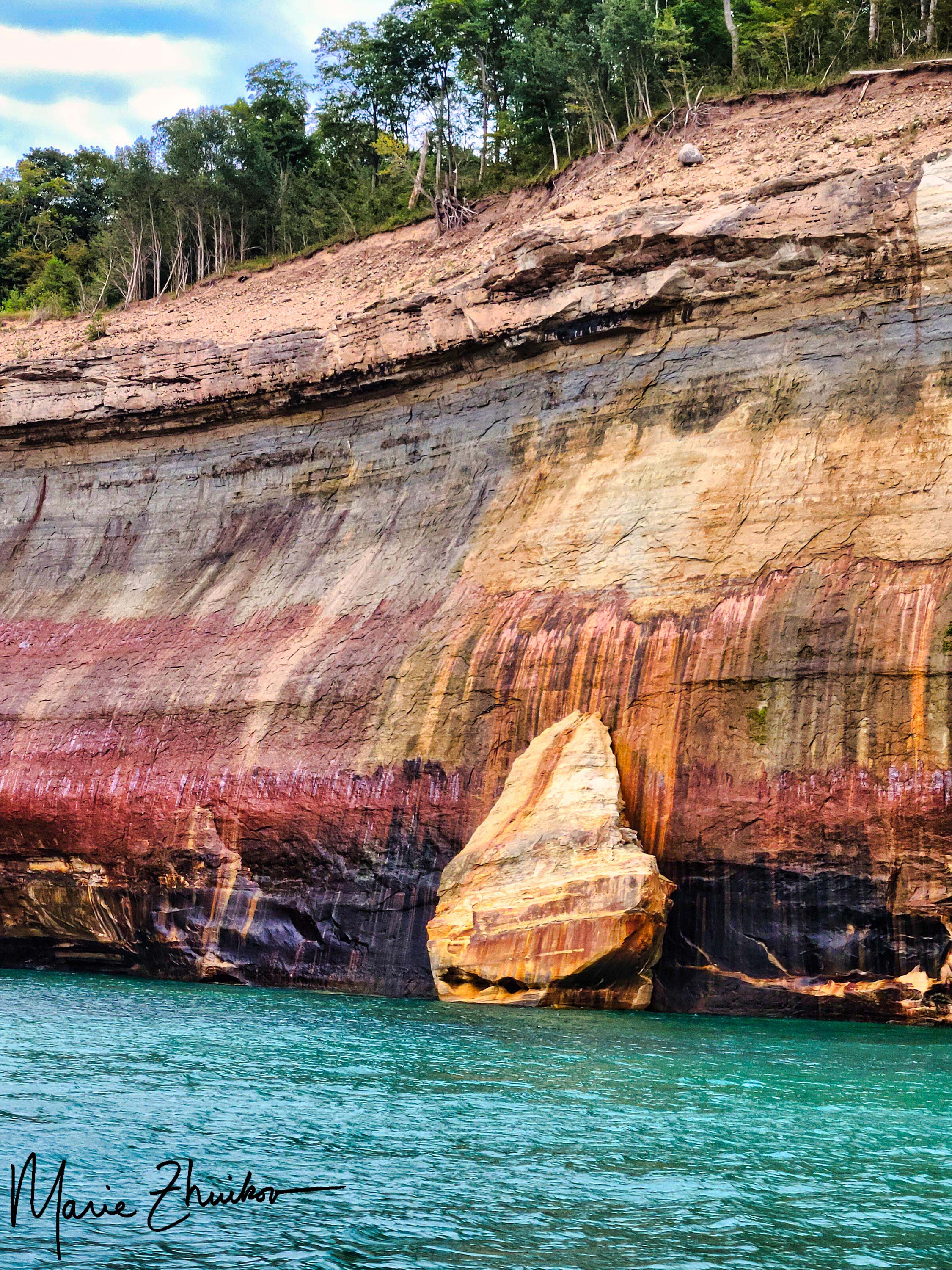
Rain moved in on our last full day at Pictured Rocks. It foiled our morning plans to hike from our campground (Hurricane River, Lower Loop) to the Au Sable Lighthouse, a 3-mile round trip. But after Russ and I read and were generally slothful, the rain stopped in the afternoon and we were able to hike.
The “trail” to the lighthouse is more like a gravel road. In fact, the park employees who staff it drive on it with their car. It’s mostly level and easy walking along the shore of Lake Superior. Several shipwrecks lie on the beach near the lighthouse, but we couldn’t access them because of the rough waves.
The treacherous sandstone makes up Au Sable Point.
The light station is comprised of a small museum, the lighthouse and keeper’s quarters, a foghorn signal building, two historic outhouses (plus one the public can use), and a small brick oil building.
I’d wanted to visit this particular lighthouse for several years – ever since I discovered it’s the twin of the lighthouse on Outer Island in the Apostle Islands National Lakeshore. I would like to set a novel in the Outer Island lighthouse but was unable to tour inside it, so the Au Sable Light was the next best thing! Tours are offered during the summer for $5.
With its underwater reefs and thick fogs, Au Sable Point is a hazard to Lake Superior mariners. The lighthouse was built in 1874, the same year as the Outer Island Lighthouse. The light tower is 86 feet high. In 1945, the U.S. Coast Guard took over operation, replacing civilian keepers. In 1958, the Coast Guard converted the light station to an automatic, unattended light and discontinued the fog signal. The station became the property of the park service in 1968. The Coast Guard maintains the small LED beacon and solar panel that charges its battery. The park has completed several restoration projects over the years.
The Au Sable Lighthouse as the fog rolled in.
The furnishings inside the lighthouse are not original, but they are of the appropriate time period. The keeper’s quarters consist of a kitchen, dining room, living room, bedroom, work room and several closets. The lighthouse tower can be accessed directly from the living quarters.
The second floor of the keeper’s quarters is much like the first and was built for the assistant keeper’s family. Tours include a trip up the 90 steps to the top of the tower, with its impressive view of Lake Superior and the surrounding forest.
After the tour, Russ and I wandered the grounds (with me taking photos). As we prepared to leave for the hike back to the campground, a fog rolled in, completing the ambiance.
Our evening plans included a drive to Munising to trade in our Spam camping food for more elegant fare. We made reservations at Tracey’s at Roam Inn. It was pricey, but the food was worth it! I had the Lakeshore Pan Roast – a seafood stew made with lobster, whitefish and scallops in reposado cream (made with tequila). Russ had the Grass-Fed Bison Filet Mignon. You can choose three different ways for your meat to be prepared. He chose the “House” method, which involves covering the meat in pepper and serving it with mashed potatoes, birch syrup asparagus, and morel mead cream. If you like pepper, this is the dish for you.
The Lakeshore Pan Roast from Tracey’s Restaurant in Munising, MI.
Both of our meals were luscious and provided the perfect end to a wonderful trip. For dessert, Russ had the chocolate cake (served with raspberry sauce and whipped cream), and I had the crème brulee served with lingonberry sauce and a stroopwafel (a Dutch waffle cookie with caramel filling). This put our meals over the top!
Chocolate cake for dessert.
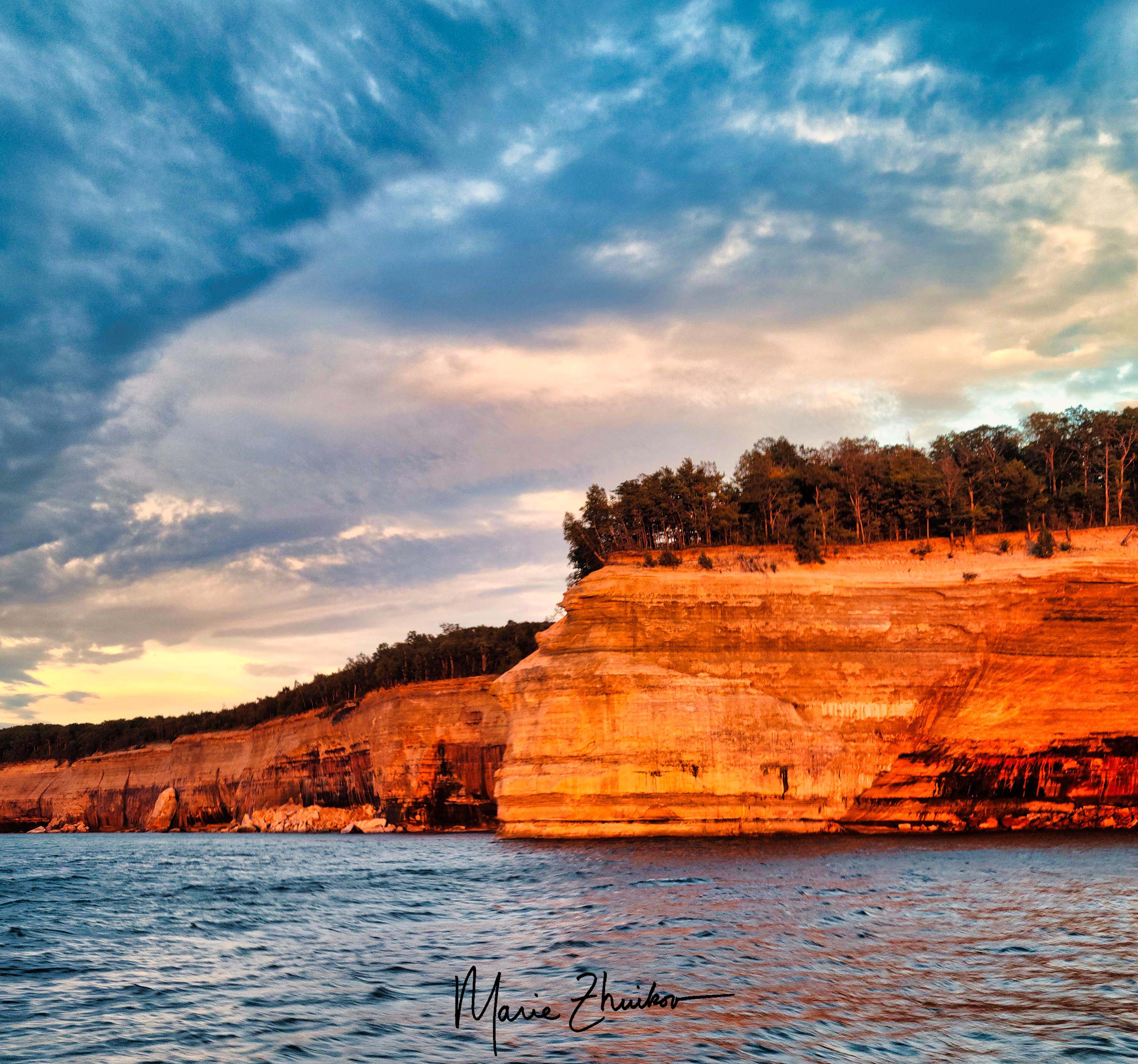
As we dined, we reflected on our experience. I was tickled by how excited people became from seeing “rocks.” On our sunset cruise, they were taking selfies with the various rock formations as well as cell phone videos to share with friends. Calling the Pictured Rocks National Lakeshore “just a bunch of rocks” (like our church friend did) was like calling the Grand Canyon “just a big hole in the ground.”
The next day, we would drive home with our Scamp. But we would do so filled with a new appreciation for an area we had driven past many times but never had time to visit.
One of my favorite images from the Pictured Rocks sunset cruise.
Pictured Rocks National Lakeshore in Michigan has plenty of wonderful overlooks across Lake Superior with great views (for some, see my previous post here).
But the best way to see the sandstone rock formations is via boat. Russ and I took a sunset cruise the first full day of our trip. We knew the weather would be changing to rain the next day, so we didn’t want to miss the opportunity for good photos.
Our particular cruise left from the town of Munising. Although we arrived at the cruise dock early, apparently, we weren’t quite early enough. A huge line had already formed.
Pro tips:
Make a reservation a few days in advance for your cruise to ensure you can experience it on the day you want.
Arrive at the dock more than a half-hour early to ensure you get a good seat. Good seats for taking photos are toward the front of the top deck, which is open to the elements.
There were so many passengers, the cruise line ended up fitting us onto two boats. Russ and I nabbed seats in the middle of the top deck. Not ideal, but not that bad, either.
The captain wouldn’t let people stand up to take photos, so when we neared interesting rock formations, I had to go downstairs to the viewing platform on the back of the boat where photography was allowed.
The sunset was colorful, but even more impressive was how it reflected off the rock formations. Although the sunset cruise costs a bit more, it’s worth it for the added colors.
If there’s some way you can get out on the water in a canoe or kayak, that would be even better for taking photos, but we didn’t have time for that.
Next up: a lighthouse tour and a sumptuous meal in Munising.
Sunset over Lake Superior on our first evening camping.
When I mentioned to someone at church that Russ and I were planning on camping at Pictured Rocks National Lakeshore in Michigan, the fellow said he thought the place was overrated.
Shocked by his unusual opinion, Russ and I talked about other things with him for a bit until I had to ask why he thought it was overrated. “It’s just a bunch of rocks,” he said.
We managed to keep straight faces for the rest of the conversation, but during our Scamping trip a couple of weeks ago, it was our favorite thing to say whenever Russ and I saw one of the spectacular Jacobsville Sandstone formations in this park along Lake Superior.
We camped for three nights at the Hurricane River Campground (Lower Loop). We chose that from several other options because of its close proximity to Lake Superior plus a trail that leads to a lighthouse I’ve wanted to see ever since I learned that it’s the twin of the lighthouse in the Apostle Islands where I want to set a novel.
After a 6-hour drive from Duluth, we set up camp just in time to catch the sunset over Lake Superior. We were driving around the campground, looking for drinking water, when we caught a glorious orange glow coming through the trees. I made Russ stop the car and let me out. I ran with my camera to the rocky beach. By that time, the orange had muted to a purple-blue-orange, but I still managed to get one worthy shot.
Twelvemile Beach
The next morning, we headed out early on our bicycles. We pedaled 5 miles on the scenic, twisty-turny highway and a gravel road into Twelvemile Beach Campground. (Warning: if you do this, be prepared for hills!) Although we were perfectly happy with our campground, this one had gorgeous sites strung out along a sandy lakeshore with huge pines. If we end up returning, we’ll try this one next.
Once we biked back to our campground, we spent some time wading in Lake Superior to quiet our strained calf muscles. After lunch, we drove 12 miles to Grand Marais to resupply our ice and firewood. This quaint town reminded me of Grand Marais, Minnesota, on the lake’s North Shore in many ways, except that the beach is sandy instead of rocky.
Russ was eating cherries and spitting out the pits as we drove along. I hereby apologize to the citizens of Grand Marais for his littering. If cherry trees someday spring up in town, you’ll know who to blame. 😊
On our way back, we stopped at Sable Falls, which requires 168 steps down a stairway and another 168 on the return trip. The sight was worth it – the falls are beautiful! They come from the outflow of Grand Sable Lake. (Sable is the French word for sand.) A short way down the road from the falls there’s an overlook for the lake. We stopped and were impressed by the lake’s size and by a heavily laden apple tree rustling in the breeze.
The lighthouse in Grand Marais, MI
Sable Falls
The apple tree at Grand Sable Lake Overlook.
Our next stop was the Log Slide Scenic Overlook. Back in the 1880s, lumbermen built a wooden chute that plunged down the steep sand dunes. Logs were sent down the chute to waiting ships for transport. The wooden chute is no longer there but the impressive dunes are. It’s said that sometimes the logs would catch fire on the chute due to the friction from the sand and wood, as well as the heat of the sun.
The view from the top of the log chute at Log Slide Overlook.
Although it’s possible to walk down the path of the chute, it’s a LONG way back up, and we decided our legs had had enough exercise between biking and stair climbing. Besides, the view from the top was impressive enough.
We continued our sightseeing, driving toward Munising. We stopped at Miners Castle Scenic Overlook, which features viewing platforms for an eroded rock that looks like a castle turret. The shallows of Lake Superior around the formation were a breathtaking turquoise green, making us feel like we were in the Caribbean instead of the Upper Peninsula.
Despite this, Russ and I turned to each other and said, “Eh, it’s just a bunch of rocks.” 😊
Our final stop on this busy day was a sunset cruise out of Munising, where we saw yet more rocks. More on that in my next post.
…For the first time in my life I had failed to work for the joy of knowing the wilderness; had not given it a chance to become a part of me. –Sigurd Olson, “The Singing Wilderness”
Garretts Point Campsite
After our delightful stay on the Duckfoot Islands, we headed back toward the houseboat base. Our goal was Garretts Point, another sandy campsite in a protected cove. This was Garrett’s idea, for obvious reasons.
He successfully piloted us out into the lake. Then I decided to give houseboat driving another try. The first time I did it, my steering wasn’t so bad, despite the wind. There was less wind on this day, but my steering was much worse. I almost did a 180 with the boat! Luckily, we were in the middle of the lake, without any obstacles. That was one reason why I chose this stretch to try again.
The campsite rubber duckie
As I zigzagged down our route, I figured out my problem. I’m used to steering a sailboat with a rudder. For that, you turn the rudder in the opposite direction you want the boat to go. Not so with a houseboat. To turn right, you turn the wheel to the right. I kept wanting to do the opposite. Also, you’re steering from near the front of the boat and the motor is in the back. That’s weird, too.
Despite all this, we successfully reached the Brule Narrows again and Garrett took over. The rest of our trip to Garretts Point in a light rain was uneventful. The site is sandy, but the beach is not as big as the one at the Duckfoot Islands. The fire ring is circled by nine stately red pines. We were greeted by a sparkly rubber duckie that someone had left on a rock by the fire ring.
Garrett was excited to arrive, and we took an obligatory picture of him standing behind the official campsite sign. Russ explored in the kayak and found a huge beaver house nearby. The beaver visited us that night as we sat around the fire.
I spent most of my time reading, but I also had a chance to explore my feelings. It didn’t seem right to be able to access these rustic locations without working very hard. Sure, driving the boat was stressful, but I wouldn’t call it physical labor. I’m used to canoeing for days and sleeping on the ground. This just seemed way too easy, like we didn’t earn it. It felt surreal to sit in my fluffy bathrobe next to a rocky campsite with scraggly jack pines and the chatter of a red squirrel.
The bell on our boat
Northwoods writer Sigurd Olson had these same feelings when he flew into Quetico National Park in Canada in a seaplane. In his book, “The Singing Wilderness,” he described the switch from civilization so quickly to the wilderness as “violent” and a psychological shock. While flying into the wilderness was what he had dreamed of doing, it didn’t allow him time to adjust and to soak in the wilderness ambiance.
He wrote, “Yes, I had been on a flight, had gone far into the lake country, had taken a few trout and enjoyed myself, but inside I was still a little out of breath and somewhat baffled by what I had done.”
We had another restful night and got up early in the morning so that we could drive the houseboat back to base by 9 a.m. so that somebody else could use it. In no time at all, we were back to the base. The houseboat guys came out to us when we were in the bay to pilot the boat into the dock.
As it turns out, we arrived in the nick of time. As we were clearing our gear out of the boat, we heard on the radio that the wind had switched and picked up speed. The base issued a no-travel advisory. We were glad we didn’t get stuck out there because Garrett had a plane to catch back to New York City. Whew!
I was glad to have had the houseboat experience, but I know that the next time I visit these northern border lakes it will be with a paddle and a pack so that like Olson, I can, “feel the rocks under my feet, breathe the scent of balsam and spruce under the sun, feel the wetness of spray and muskeg, be part of the wilderness itself.”
The sandy beach at Duckfoot Islands houseboat campsite, Voyageurs National Park.
When last you heard from me, Russ, Garrett, and I were stuck in a houseboat in the dead of night, beached on rocks by an unexpected wind direction switch.
The next morning, we radioed the houseboat base and let them know about our predicament. They asked if we were comfortable trying to get the houseboat off the rocks with our little motorboat. Russ was speaking to them at the time and he said no, not with the wind still pummeling us with waves. They said they’d get someone out to tow us off the rocks.
It was an eventful morning. We weren’t the only ones having trouble. On the radio, we heard that a child fell on a houseboat near us and the family wanted to get her to a hospital, so there was that, plus others were having troubles with the wind.
It wasn’t until early afternoon before a motorboat arrived with several houseboating staff. In the meantime, we wandered around Oveson Island, rereading the Fish Camp signs and just getting antsy to leave. This was the low point of our adventure.
Our original plan was to leave early in the morning, but now that was shot since we had lost half a day. Plus, that lonely loon was hanging around again. Loons are supposed to symbolize tranquility, serenity, and the reawakening of old hopes, wishes, and dreams. But this loon was just depressing.
A terrible photo of the lonely loon.
I looked up the type of wailing call he was making and it’s the kind loons make to locate their mates or their children. This poor loon had none of those. I felt so sorry for him. His wail has half-hearted, as if he didn’t have energy for a proper one. He must be the loneliest loon in America. Perhaps he lost his mate or maybe he was too young to breed. Loons breed between four and six years old.
In any event, it was time to move to a happier houseboat site!
The houseboat guys were able to get us off the rocks with no problem. Much to our relief, they said our hull was intact, so we could continue our trip. They drove us out to the main channel, and we were on our own once more. The wind had died down, so keeping the houseboat on course was a bit easier. We drove 9 miles, including a tricky stretch through the Brule Narrows. Garrett drove most of the time, including the narrows. It seems he had a hidden houseboating talent.
My toes and my paddle board on the dark water.
We moored in Saginaw Bay at the Duckfoot Islands site. Unlike our previous site, this one was an official houseboating site, complete with sign. We chose it because it had a nice sand beach. No more rocks for us!
We spent the rest of the day paddling around the islands. I was heartened to see that the loons here were a couple with a loonlet. No more lonely loons!
I enjoyed paddle boarding through millions of waterbugs who were scribbling their indecipherable words across the water. A gentle rain fell on and off, but the wind behaved.
Back on land, I became reacquainted with my old friend, “land sickness.” This is where you feel like you’re on the water even though you’re on land. (It’s the opposite of sea sickness.) I think it came more from all the paddle boarding I was doing rather than from the houseboat. The houseboat didn’t rock much on the waves.
A campfire provided our evening entertainment. The night was restful, and we awoke, bright-eyed, for the last day of our trip.
The gorgeous sunset our first night on Rainy Lake at the Oveson Island traditional site.
When the Rainy Lake Visitor Center was dedicated in Voyageurs National Park in northern Minnesota, I was there. That was maybe about thirty-five years ago. My mother wanted to attend, and she asked me to go with her. I’m not sure why she wanted to attend except that she liked national parks and perhaps this was her way of feeling connected to a local one.
A peg-legged Voyageur at the Rainy Lake Visitor Center dedication, 1987.
The ceremony was interesting and came complete with a man dressed up as a French voyageur – one of the intrepid fur traders who plied the waters by birch bark canoe in the 16th to 19th centuries. I know I have photos of the ceremony – I’ll peruse my old albums to see if I can find any to include with this post.
This is just a long way of saying that, although I was part of the park’s beginnings, I had not visited it much, if any, since.
Russ and I had a desire for an overseas vacation this summer, but I, as the major trip planner, just couldn’t muster much enthusiasm for the effort it would require. I think I’m still recovering from all the travel we did last year in the “post-COVID” frenzy.
So, we thought of trips closer to home. Houseboating on Rainy Lake in Voyageurs popped into my head. There used to be billboards advertising the houseboat companies on a local major highway and I always thought it would be fun to try.
The idea appealed to us because it would be like being in the wilderness, except with comfortable beds, a refrigerator, and no need to paddle (except for fun) due to the houseboat’s motor. We have some experience driving boats. It sounded perfect! Plus, we’d get to know the park better.
With enthusiasm, we began planning and invited Russ’s grown son Garrett along on the four-night, five-plus-day trip.
Campfire our first night on Oveson Island, Voyageurs National Park.
After we arrived at the houseboat base just outside International Falls, Minnesota, we loaded our gear onto the watercraft, a 42-foot Minnitaki, which sleeps two to six people. From the dark paneled interior, it looked like the boat was built in the mid-1980s. Some of the houseboats feature hot tubs, but we did not feel the need for one of those. We were being decadent, but not THAT decadent.
We were required to rent a small motorboat to tow along behind us in case of emergencies. The motorboat is also useful for exploring or fishing. We also bought 3 bundles of firewood. We brought our own paddleboards and a kayak, which easily fit on the top level of the houseboat.
We were oriented to its somewhat complicated workings by one of the staff, who also piloted it out of the harbor and made sure we were comfortable driving it before he was picked up by another staff person in a motorboat and we were left alone.
It felt rather like when I was cast adrift on a paddleboard for the first time. However, this was a 42-foot, a much more expensive craft! I was glad we opted to pay the hull insurance the company offered.
The weather was sunny with a wind at about 6 mph. That might not seem like much wind, but in a boat shaped rather like a huge bathtub, it was a lot. We all took turns driving and were surprised by how hard it was to keep a straight course. The boat comes equipped with computer navigation and the lake comes equipped with red and green buoys. We just needed to keep the red buoys on our right and the green ones on our left so that we did not run aground. Easier said than done.
After zigzagging across the lake for about 8 miles, we were ready to moor for the night. Rainy Lake features designated houseboat sites on land where the boats need to be tied up for the night by 6 p.m. No driving boats in the dark is allowed, nor is anchoring.
Walk the plank! How we got off the houseboat and onto land.
The first designated site we wanted was already occupied so we chose a “traditional” site on a nearby island. We weren’t sure of the island’s name because it wasn’t listed on our chart, but we figured out later it was Oveson Island. Traditional sites don’t have houseboat signs and they are a bit more primitive than the designated sites.
We tied the houseboat to three trees as instructed and walked down the skinny wooden gangplank to explore the small site, which came with a fire grate. It looked much like any wilderness campsite with rocks and pine trees.
After a scrumptious steak dinner thanks to the houseboat’s gas grill, I explored the island. A well-worn trail led away from our campsite. I was surprised when it ended at a well-built privy. I was like, “What the heck?!”
A trail from the privy led to a boardwalk and a small picnic area. Next to that were several buildings painted a light green. Interpretive signs along the way informed me this was the Oveson Fish Camp, built by Harry Oveson and occupied during summers from 1959 to 1985. Harry fished for whitefish and walleye.
Oveson Fish Camp, Voyageurs National Park.
An icehouse, a fish processing shed, and Harry’s house make up the camp. There’s also a large dock so boaters can visit.
Besides being a fisherman, Harry was a jack-of-all trades. He was an inventor, ham radio operator, mink farmer, home flipper, and an avid reader and bird watcher. I figured out later that I am acquainted with his nephew, Tony, who still lives near the park. Harry’s descendants operate a lodge on Pelican Lake, about an hour’s drive away.
Excited by my discovery, I scampered back to the houseboat. When I arrived, I told the guys that I found something, but I didn’t tell them what. They followed me down the trail, curiosity piqued.
I stopped proudly at the privy and said, “I found a privy!!”
They looked unimpressed until I laughed and pointed down the boardwalk where they could see the rest of the fish camp buildings. They were more impressed by this. (It’s the wilderness. Sometimes, you need to make your own entertainment.)
We spent the rest of the evening exploring the camp and later had a campfire at our site. At sunset, a single loon stationed itself off our stern in the small bay. It wailed a few times, making the wilderness ambiance complete.
A lone-tree island I paddled by on my SUP.
We also heard noises nearby that sounded like people having a party. Garrett thought it might be geese. Later, it began to sound more like geese to me, but not Canada geese. I wasn’t sure what they were.
The night sky was filled with gobs of stars – Voyageurs National Park was just recently certified as an official Dark Sky Park, so it’s protected from light pollution.
Our sleep on the boat was restful except for the thumping of the motorboat against the stern. We hadn’t read the part in the boat manual yet about tying the motorboat up on shore for the night, but you can be sure we did that the following night. That turned out to be a very good thing!
In the morning, I enjoyed my mug of hot chocolate outdoors on the back porch of the boat while wearing my fluffy light blue bathrobe. I have never worn a bathrobe in the wilderness, and this felt especially luxurious.
The weather forecast called for sun, heat, and twice as much wind as the day before. Given the difficulty we had steering the boat, we decided to stay put. The wind was expected to die down the next day.
We spent our time paddling around the island in our kayak and paddleboards. Garrett and I saw a bald eagle, a single loon that I was pretty sure was the same one from the previous evening, and a regal pair of trumpeter swans. These must have been making the mysterious geese-like sounds we heard the night before.
The day was restful – full of reading, games, conversation, and eating. I watched a red squirrel drink from a puddle. I investigated the otter scat – full of crayfish parts – that littered the shoreline rocks. The sunsets both nights were beautiful – the sun made into an orange and then huge red ball in the sky from haze from wildfires in Canada. The loon parked itself off our stern again, giving its mournful wail. It sounded lonely. I called back to it a few times to give it some semblance of company.
Garrett and the trumpeter swans
However, the night was not restful. Around midnight, the wind switched so that it was directly behind us, causing our houseboat to bang into the shoreline rocks. Russ got up and retied our lines, but it was too late; our boat was wedged sideways on a rock ledge. After his effort, much of the bumping sounds stopped, but we had visions of a hull breach and our trip possibly being over. Once again, I was thankful we bought that hull insurance.
We’d have to radio the houseboat base the next morning and let them know the bad news. I mulled this over while listening to the loon, who had begun calling again.
Was our trip over? If not, how did we get out of this fix? Read the next installment, coming soon!
I had the chance to meander to Stockton Island, one of several islands in the Apostle Islands National Lakeshore in Lake Superior a couple of weeks ago. I was there to cover what the National Park Service is doing to make their facilities on the island more accessible to disabled people. I’ll be writing a story about that for work, but I also got a tour of the island by former park ranger, Neil Howk, who gave us (there were about 8 of us) the skinny on the history of black bears on the island.
Neil Howk imparts his knowledge about bears.
Neil worked for many years in the Lakeshore and is now on the board of the Friends of the Apostle Islands, which organized the tour on a sunny, breezy Friday. Neil took us on a short hike on the trail that leads through the campground on Stockton Island to the signpost for campsite number 4. We took a sharp right and began bushwhacking into the woods. Neil knew there was a bear den nearby.
After not too much whacking or getting whacked by tree branches, we came to a deadfall – a tree that had been blown over by wind. Neil said the bear had made its den among the tree roots, which provided a fairly snug place to spend the winter.
He felt okay taking us to this location because: 1) It’s not winter, so no bear will be actively hibernating there, and 2) Bears usually only use a hibernation site once, so disclosing its location should not endanger the privacy of any bears (except if another one ends up using it!)
Besides overwintering in dens in rocks or tree roots, black bears have also been known to hibernate inside hollow trees and even in eagle’s nests. I did not know the eagle’s nest thing. I also learned many other new bear trivia, such as: bears don’t poop all winter. Neil said they eat grass in spring to get their bowels going again.
The deadfall bear den that Neil Howk showed us on Stockton Island.
Also, cannibalism is normal for bears. Males will sometimes eat cubs – presumably ones that aren’t related to them, in order to bring females into estrus sooner so that they can procreate with them. And bears will also eat meat (besides the berries, ants, and other things that bears are known to consume). Neil said that deer fawns and chipmunks are among their favored meaty fare.
Another fact that Neil conveyed is that when bears were first counted on Stockton Island – sorry, I’m not sure when that began – there were only a couple. But now there are 20 known to live there. I can attest to their presence. On my several trips there, I’ve seen many bear tracks on the island’s beaches. (I’ll try to dig up some of my photos of those for this post.)
Black bears like to gnaw upon and otherwise dismember the wooden campsite markers on Stockton Island.
One memory that emerged during the tour came from a trip I made to Russia many years ago. One of my former husband’s relatives bragged about a bear he had shot. Granted, this relative liked his vodka and ended up chasing one of my young sons around the picnic table where we were eating – he was a rather scary, imposing figure, somewhat bearish. At some point, he showed us photos of his triumphant hunt. From the snow in the photo and the location, it became obvious that he had shot a hibernating bear. So much for sportsmanship, but I guess maybe they do things differently in Russia!
Anyway, I learned some things I didn’t know about bears from this tour, and I hope you did, too.
An Ice Age exhibit at the Bell Museum of Natural History, including a mammoth, giant beaver and musk ox.
I recently had the chance to meander through two very different natural history museums. One was public and the other not so much. Both impacted my psyche.
The public one was the Bell Museum of Natural History. This was one of my favorite hangouts during my college days when I was minoring in biology. (I won’t divulge how many decades ago that was!) Besides the obvious appeal to the science-minded, my poetry professor once took us to the museum for inspiration purposes.
The new Bell Museum.
The Bell Museum used to be on the Minneapolis Campus of the University of Minnesota in Minneapolis. Now, it has a “new” facility on the St. Paul Campus.
Russ indulged me (smart man) and tagged along as we visited the Bell’s planetarium where we learned about astrobiology, or the search for life on other planets. The planetarium has a domed Imax theater roof. We saw a movie that was narrated by an actual museum staffer (in real life). This was unexpected, but cool, because we could ask questions. Many children in the audience did, and I was impressed by their interest in the planets.
One thing I learned was that we’ve had unmanned spacecrafts land on Venus. Somehow, I missed that news. It was so interesting to learn about the inhospitable conditions there – the landing crafts only lasted a few hours before they were incinerated by Venus’s hot temperatures.
Antlers on the wall, Bell Museum of Natural History.
In the natural history part of the Bell Museum, I was heartened to see that the painted dioramas I so loved in the old museum had been moved into the new museum. There was the wolf pack on the North Shore of Lake Superior. There were the sandhill cranes of the Platte River. I can’t imagine what it must have taken to move those overland to the St. Paul Campus intact!
Plus, the museum has many new exhibits that deal with the evolution of life on this planet. I don’t think they knew that stuff when I was a college student.
The not-so-public museum was the Zoology Museum on the University of Wisconsin-Madison Campus. I meandered into it for work. Every year, my boss at Sea Grant organizes a field trip for us science communicators and this year, our focus was Madison. This is where most Wisconsin Sea Grant staff are located, but there are many staffers from other areas in the state (including me), so all this was new to me.
The UW Zoology Museum is mainly for researchers and it was formed by researchers. Many of the specimens were collected during science expeditions or they came from nearby zoos. To give you an idea of its layout, there’s a bone room, where bones of animals are stored in boxes. There’s a skin room where animal skins are stored in drawers (think about an entire polar bear fitting into a small drawer). There’s also a taxidermy room that features various birds and mammals.
A soulful lion greeted us in the taxidermy room of the Univ. of Wisconsin-Madison Zoology Museum.
As we entered the facility, we had to carefully close doors behind us so that bugs and other contamination couldn’t follow us and destroy the samples.
In the lower level of the building is a fish room where various species of fish are stored in ethanol in jars and pails. This is in case the jars ever break – that way they won’t flood the other floors. The various jars are on shelves that are moveable. These are called compacter shelves. As opposed to stationary shelves, these can be easily moved so that more can fit in a room than otherwise possible. Zooplankton are also preserved here. Various historic scientific instruments are scattered on nearby tables.
Another part of this basement room features preserved mammals, reptiles, and invertebrates in ethanol.
It was all kind of creepy and gave me some good ideas for a horror story. There were so many many samples! Something about all those dead animals in jars seemed wrong, even though it’s for the sake of science.
A polar bear in a drawer.
The piece de resistance, however, was a room we didn’t even get to see. It’s the room with the flesh-eating beetles. The museum staffer described the beetles as the best method to remove the “meat” from the bone samples that the museum staff wants. The beetles live up to their name, eating off the flesh from the bones. The dark room the beetles live in is down a concrete corridor that would give even Edgar Allan Poe pause. We did not get to see it, but our tour host’s description was good enough.
The beetles do a much better job of cleaning than any other method, so the university still uses them, even in the 21 Century.
Mice and bats in jars in the Zoology Museum.
I realize that science needs access to real animals for research purposes, but I must admit that this research museum creeped me out much more than the public museum. I guess that’s to be expected. I’m glad I was able to see both of them.
Look for the fruits of this field trip in my fiction some day! I just discovered that there’s a horror sub-genre called “dark academic.” The Harry Potter series fits into this – think gothic architecture, pleated skirts, melancholia, and leather satchels. This is opposed to “light academic.” “Pride and Prejudice” fits into this – think of the opening of the movie where Elizabeth Bennet Walks through a sunny field reading a book. It’s all about light and happiness. My story will be more along the dark academic vein.
My takeaway with this post? Visit a natural history museum near you sometime. It might spark something!